Stádlec | |
|---|---|
 Stádlec Suspension Bridge | |
 Flag  Coat of arms | |
 Stádlec Location in the Czech Republic | |
| Coordinates: 49°22′47″N 14°29′42″E / 49.37972°N 14.49500°E | |
| Country | |
| Region | South Bohemian |
| District | Tábor |
| First mentioned | 1287 |
| Area | |
| • Total | 18.14 km2 (7.00 sq mi) |
| Elevation | 449 m (1,473 ft) |
| Population (2023-01-01)[1] | |
| • Total | 587 |
| • Density | 32/km2 (84/sq mi) |
| Time zone | UTC+1 (CET) |
| • Summer (DST) | UTC+2 (CEST) |
| Postal code | 391 62 |
| Website | www |
Stádlec is a market town in Tábor District in the South Bohemian Region of the Czech Republic. It has about 600 inhabitants.
Administrative parts
Villages of Hájky, Křída, Slavňovice and Staré Sedlo are administrative parts of Stádlec.
Geography
Stádlec is located about 13 kilometres (8 mi) west of Tábor and 70 km (43 mi) south of Prague. It lies in the Tábor Uplands. The Lužnice River forms the eastern municipal border. There are several fish ponds in the municipal territory, the largest of them is Mlýnský Stádlec.
History
The first written mention of Stádlec is from 1287, when it was a property of Záviš of Falkenstein.[2]
Sights
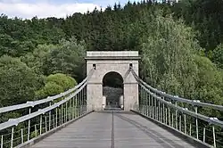
Stádlec is known for its rare Stádlec Suspension Bridge over the Lužnice river. It connects Stádlec with the village of Dobřejice (a part of Malšice). The bridge is protected as a national cultural monument.[3]
Notable people
- František Křižík (1847–1941), engineer and inventor; died here
References
- ↑ "Population of Municipalities – 1 January 2023". Czech Statistical Office. 2023-05-23.
- ↑ "Představení Stádlce" (in Czech). Obec Stádlec. Retrieved 2022-07-08.
- ↑ "Řetězový most" (in Czech). National Heritage Institute. Retrieved 2023-06-16.