South Carolina Highway 80 | ||||
|---|---|---|---|---|
| J. Verne Smith Parkway | ||||
 | ||||
| Route information | ||||
| Maintained by SCDOT | ||||
| Length | 5.620 mi[1][2] (9.045 km) | |||
| Existed | 2002–present | |||
| Major junctions | ||||
| West end | ||||
| ||||
| East end | ||||
| Location | ||||
| Country | United States | |||
| State | South Carolina | |||
| Counties | Greenville, Spartanburg | |||
| Highway system | ||||
| ||||
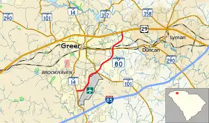
South Carolina Highway 80 (SC 80) is a 5.620-mile (9.045 km) primary state highway in the state of South Carolina. The highway serves as a bypass, connecting SC 14 to U.S. Route 29 (US 29) in Greer.
Route description
SC 80 is a four-lane expressway, which begins at SC 14, on the backside of the Greenville-Spartanburg International Airport. Going in a northeasterly direction, the first 0.8 miles (1.3 km) include a narrow median before splitting into a divided highway. Top speed limit along the highway is 55 miles per hour (89 km/h) with several at-grade intersections and one grade-separated intersection. The highway ends at US 29 (Wade Hampton Boulevard). The highway is shared with truck routes of SC 101 and SC 290.[3]
History
The second incarnation of SC 80 was established in July 2002 as a new primary route running from SC 101 to US 29. In April 2005 it was extended to SC 14.
The first SC 80 existed from 1937 to 1962 as a new primary route from SC 181 in Fair Play to SC 18 in Anderson. It was decommissioned after Lake Hartwell formed a gap in the highway with the westernmost part becoming part of SC 243 and the rest becoming Old Dobbins Bridge Road (S-4-22 and S-4-23).[4]
Major intersections
The entire route is in Greer.
| County | mi[5] | km | Destinations | Notes | |
|---|---|---|---|---|---|
| Greenville | 0.000 | 0.000 | Western end of SC 101 Truck concurrency; western terminus of SC 80; eastern terminus of Tandem Drive | ||
| Spartanburg | 2.120 | 3.412 | Eastern end of SC 101 Truck concurrency; southern terminus of SC 101 Truck | ||
| 4.154– 4.170 | 6.685– 6.711 | Western end of SC 290 Truck concurrency; eastern terminus of SC 290 Truck; interchange | |||
| 5.620 | 9.045 | Eastern end of SC 290 Truck concurrency; eastern terminus of SC 80; southern terminus of Gary Armstrong Road | |||
1.000 mi = 1.609 km; 1.000 km = 0.621 mi
| |||||
See also
References
- ↑ "Highway Logmile Report". South Carolina Department of Transportation. Retrieved December 24, 2020.
- ↑ "Highway Logmile Report". South Carolina Department of Transportation. Retrieved December 24, 2020.
- ↑ Google (February 11, 2013). "Overview map of SC 80" (Map). Google Maps. Google. Retrieved February 11, 2013.
- ↑ "SC 80". Mapmikey's South Carolina Highways Page. Retrieved October 31, 2020.
- ↑ "Highway Logmile Report". South Carolina Department of Transportation. Retrieved December 24, 2020.
External links
 Media related to South Carolina Highway 80 at Wikimedia Commons
