South Carolina Highway 557 | ||||
|---|---|---|---|---|
 | ||||
| Route information | ||||
| Maintained by SCDOT | ||||
| Length | 6.710 mi[1] (10.799 km) | |||
| Existed | 1942–present | |||
| Major junctions | ||||
| South end | ||||
| North end | ||||
| Location | ||||
| Country | United States | |||
| State | South Carolina | |||
| Counties | York | |||
| Highway system | ||||
| ||||

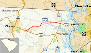
South Carolina Highway 557 (SC 557) is a 6.710-mile (10.799 km) primary state highway in the U.S. state of South Carolina. It serves as a connector route between Clover and Lake Wylie.
Route description
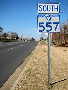
First sign for SC 557 south in Lake Wylie
SC 557 is a two-lane rural highway that traverses 6.7 miles (10.8 km) from SC 55 near Clover to SC 49/SC 274 in Lake Wylie. The highway provides travelers a more direct route to and from Charlotte. Though it runs physically west-to-east, it is signed as a north-south highway with its western end as its southern terminus and vice versa.[2]
History
The highway was established in 1942 as a renumbering of SC 59. The route has changed little since.
Major intersections
The entire route is in York County.
| Location | mi[1] | km | Destinations | Notes | |
|---|---|---|---|---|---|
| Clover | 0.000 | 0.000 | Southern terminus | ||
| Lake Wylie | 6.710 | 10.799 | Northern terminus | ||
| 1.000 mi = 1.609 km; 1.000 km = 0.621 mi | |||||
See also
References
- 1 2 "Highway Logmile Report". South Carolina Department of Transportation. Retrieved December 28, 2020.
- ↑ Google (January 8, 2012). "South Carolina Highway 557" (Map). Google Maps. Google. Retrieved January 8, 2012.
External links
Template:Attached KML/South Carolina Highway 557
KML is from Wikidata
Wikimedia Commons has media related to South Carolina Highway 557.
This article is issued from Wikipedia. The text is licensed under Creative Commons - Attribution - Sharealike. Additional terms may apply for the media files.