| Sebeș Sebes, Mühlbach, Frumoasa | |
|---|---|
 | |
 | |
| Location | |
| Country | Romania |
| Counties | Sibiu, Alba |
| Towns | Sebeș |
| Physical characteristics | |
| Source | Mount Cindrel |
| • location | Cindrel Mountains |
| • coordinates | 45°32′59″N 23°43′38″E / 45.54972°N 23.72722°E |
| Mouth | Mureș |
• location | Alba Iulia |
• coordinates | 46°02′25″N 23°33′32″E / 46.04028°N 23.55889°E |
• elevation | 214 m (702 ft) |
| Length | 96 km (60 mi) |
| Basin size | 1,304 km2 (503 sq mi) |
| Discharge | |
| • average | 9 m3/s (320 cu ft/s) |
| Basin features | |
| Progression | Mureș→ Tisza→ Danube→ Black Sea |
| Tributaries | |
| • left | Sălanele, Prigoana |
| • right | Ciban, Dobra, Secaș |
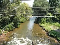
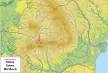
The Sebeș (Hungarian: Sebes, German: Mühlbach) is a left tributary of the river Mureș in Transylvania, Romania.[1][2] The upper reach of the river (upstream of Lake Oașa) is also known as Frumoasa.[3] The Romanian and Hungarian name Sebeș and Sebes originate from the Hungarian adjective sebes meaning "speedy", while the German name means Mill Creek. The source of the river is on the south slope of the Cindrel Mountains, in the southwestern part of Sibiu County. It flows through the reservoirs Oașa and Tău.[1] It discharges into the Mureș in Oarda, near Alba Iulia.[3] Its length is 96 km (60 mi) and its basin size is 1,304 km2 (503 sq mi).[2]
Towns and villages
The following towns and villages are situated along the river Sebeș, from source to mouth: Dobra, Șugag, Căpâlna, Laz, Săsciori, Sebeșel, Petrești, Sebeș, Lancrăm, Oarda.
Tributaries
The following rivers are tributaries to the river Sebeș (from source to mouth):[2]
References
- 1 2 "Planul național de management. Sinteza planurilor de management la nivel de bazine/spații hidrografice, anexa 7.1" (PDF, 5.1 MB). Administrația Națională Apele Române. 2010. pp. 393–395.
- 1 2 3 Atlasul cadastrului apelor din România. Partea 1 (in Romanian). Bucharest: Ministerul Mediului. 1992. pp. 171–174. OCLC 895459847. River code: IV.1.102
- 1 2 Sebes / Frumoasa (jud. Sibiu), e-calauza.ro