Seaview | |
|---|---|
 | |
| Country | New Zealand |
| City | Lower Hutt |
| Local authority | Hutt City Council |
| Electoral ward | Harbour |
| Community board | Petone Community Board[1] |
| Petone | Moera | Gracefield |
|
|
||
| Eastbourne | Sorrento Bay |
Seaview is an industrial suburb of the city of Lower Hutt, itself a suburban area of greater Wellington.[2] Situated on the eastern coast of the Hutt Valley, it curves between Te Awa Kairangi / the Hutt River and Petone (to the west), and the bays of Eastbourne to the south. Traditionally a very industrial suburb, an annex of the larger neighbouring Petone, Seaview has undergone rejuvenation as the local car-industry has died out. Known for boganesque motor-racing, sultry weather, its former car-industry and current revitalisation, the suburb has made a name for itself in Wellington in recent years.
History and culture
The area was prosperous for a period of time during precolonisation; the local Māori iwi, Te Āti Awa, had a village here called Owhiti. It was based on the riches of the Waiwhetū Stream, which was navigable well into the Hutt Valley. However, disaster struck when the 1855 Wairarapa earthquake occurred, changing the river into the low-lying stream it is today, and making the area a desolate strip of sandy swampland. The local shipyards were destroyed, and Pākehā settlers focused their efforts on Petone instead.
Seaview was undeveloped until Caltex decided to move operations into the area in 1929, controversially building a plant on the site of the former Wharenui of Owhiti. The Great Depression spurned local workers on, and Seaview began to grow into a trading estate that belied its small size. Ford opened an automobile plant here in 1936 in a distinctive and recently refurbished building, and so began a long production of Zodiacs, Zephyrs, Consuls, Prefects, Anglias and the Thames trucks and Fordson tractors.[3][4] This history of car manufacturing, mostly done by local women, cemented Seaview's dynamic car culture, one that once again belies the suburb's size. Dulux established a plant in 1939, followed by more companies making industrial goods such as bolts, rivets, paint and chemicals, both in Seaview and the adjacent suburb of Gracefield as space became scarce. With this, Seaview had developed a prosperity that would boom for nearly sixty years, albeit one prosthetic and pollutive.[5][6]
Seaview's culture has been shaped by the job losses and subsequent existentialism that came from closing of the Ford plant in 1988, as well as classic values of having a good time and rowdy fun. The boganesque culture here is highlighted by the local Port Road Drags. Many the classic cars built here, as well as Chevrolets and Pontiacs, often return to the marina for the annual Drags, a somewhat infamous (but not nearly as so in comparison to the local demolition derby, which today has a focus on family in an attempt to soften its image) drag race that has taken place on the Port Road each November since 1966. It is the longest running street drags in Australasia. Much of the Port Road is closed off especially, and classic cars fill Wellington on their way to Seaview on the day. Boy racers travel down from all over the country for it, especially ones in the Hutt Valley. In 2020, it was called off early when a spectator was almost killed. The marina is a considerably more placid affair during the rest of the year, when it is filled with many fishermen's boats.[7][8][9][10]
Seaview wharf
Seaview wharf is a marine fuel terminal at the north-east of Wellington Harbour. The fuel terminal is the main point of supply for liquid fuels for the lower North Island, and is also a backup point of supply for other parts of the North Island. The wharf was originally built around 1975, and is now owned by CentrePort Wellington. The landward end of the wharf is at Point Howard and it is approximately 600 metres (2,000 ft) long. Fuel pipelines along the wharf connect with bulk fuel storage facilities in Seaview. The fuel terminal handles approximately one million tonnes of fuel annually.[11]
The wharf was damaged in the 2016 Kaikōura earthquake, but was able to continue operating. In 2021 a $60m project was commenced to improve the seismic resilience of the wharf.[12]
Demographics
Seaview is included in the Gracefield statistical area.[13]
Wastewater treatment plant and outfall
Prior to 2001, wastewater from the entire Hutt Valley was screened and then pumped without any further treatment via a pipeline along the eastern coastline of Wellington Harbour to an ocean outfall near the harbour entrance at Pencarrow Head. By the 1990s, the discharge of untreated sewage into the ocean had become environmentally unacceptable.[14] Planning for a new sewage treatment plan began in the mid 1990s. In 1998, tenders were called for a design, build and operate contract for a treatment plant to be built in Seaview that would provide secondary treatment of all sewage from the Hutt Valley and Wainuiomata.[14] It was to be located close to the Waiwhetū Stream. A contract was let in 1999,[15] and the plant was commissioned in 2001.[16]
In March 2022, Wellington Water reported a leak in the pipeline to the outfall, in the Seaview area. Repairs required the shutdown of the pipeline, and the discharge of fully treated wastewater into Waiwhetū Stream while the repairs were carried out.[17] In September 2023, Wellington Water predicted that pipeline shutdowns for repairs will become increasingly frequent, possibly rising to 30 times per year, with a typical repair time of 1 week, leading to repeated discharges of treated wastewater into the Waiwhetū Stream. Options presented to the Hutt City and Upper Hutt councils included refurbishment of the existing pipeline, or the construction of a new pipeline in Wellington Harbour. The forecast costs of a new outfall pipeline were approximately $700 million, with a further $300 million required for upgrades to the Seaview treatment plant, including a replacement sludge drier.[18]
Gallery
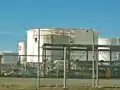 Oil Tanks in Seaview, November 2020
 Old industrial buildings adorned by Pōhutukawa.
 Industrial landscape.
.jpg.webp) 1975 Ford Cortina, manufactured at the Ford plant. Hundreds of thousands of Fords were built here from 1936 to 1988.
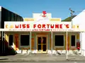
1975 Ford Cortina, manufactured at the Ford plant. Hundreds of thousands of Fords were built here from 1936 to 1988.- Miss Fortune's café, a more trendy and bright feature of Seaview.
References
- ↑ "Community Boards". Hutt City Council. Retrieved 28 May 2023.
- ↑ "History and Vision Seaview of Lower Hutt, on HuttCity".
- ↑ "Former Ford Seaview assembly plant to get upgrade when Placemakers move out". Stuff. 20 March 2016. Retrieved 29 November 2020.
- ↑ "History". www.seaviewbusiness.co.nz. Retrieved 29 November 2020.
- ↑ "History". www.seaviewbusiness.co.nz. Retrieved 29 November 2020.
- ↑ "Petone vision statement". iportal.huttcity.govt.nz. Lower Hutt Council. Retrieved 24 January 2021.
- ↑ "Boy racers in Wellington: 'We're not here to scare people'". RNZ. 6 August 2019. Retrieved 29 November 2020.
- ↑ "Port Road Drags, Port Rd,Seaview, Lower Hutt (2020)". www.findglocal.com. Retrieved 29 November 2020.
- ↑ "Port Road Drags". portroad.co.nz. Retrieved 29 November 2020.
- ↑ "History, speed and burnt rubber a drawcard for Port Road Drags". Stuff. 16 November 2017. Retrieved 29 November 2020.
- ↑ Juno, W.; Hall, L.; Delaney, A.; Terry, P. (2021). "Seaview Wharf: risk-based thinking underpins the future" (PDF). NZ Society for Earthquake Engineering.
- ↑ Tso, Matthew (27 June 2021). "$80m quake-resilience upgrade for lower North Island's fuel supply line in Lower Hutt". Stuff. Retrieved 27 May 2023.
- ↑ 2018 Census place summary: Gracefield
- 1 2 Schouten, Hank (16 March 1998). "Seven signal Hutt sewage interest". Evening Post. ProQuest 314533367.
- ↑ Schouten, Hank (24 November 1999). "Hutt sewage plant cheaper". Evening Post. ProQuest 314635961.
- ↑ "Report card for Seaview sewage plant". Evening Post. 14 November 2001. ProQuest 314817886.
- ↑ "Wastewater discharging from broken pipeline into Waiwhetu Stream". Scoop. 9 March 2022. Archived from the original on 12 March 2022. Retrieved 21 May 2022.
- ↑ Boyack, Nicholas (23 September 2023). "$1 billion shock for Hutt Valley ratepayers". www.thepost.co.nz. Retrieved 24 September 2023.
External links
- History of Seaview at Seaview Business Association