Sattari is a village in Malda district of the state of West Bengal, India. Sattari is known for producing mango (aam) supply, lace (gamchha), and carpet work. It is the headquarters of Binodpur Gram Panchayat (village council) on which it is represented by 6 of the 13 seats.
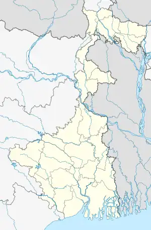
Geography
M: municipal town, CT: census town, R: rural/ urban centre, F: Facility, H: historical centre
Owing to space constraints in the small map, the actual locations in a larger map may vary slightly
Location
Sattari is located at 24°59′37″N 88°02′24″E / 24.9937°N 88.0400°E the English Bazar tehsil (transl. administrative unit) or community development block of Maldah district in West Bengal, India. It is situated 14.4 kilometres (8.9 mi) from sub-district headquarter Malda and 15.1 kilometres (9.4 mi) from the district headquarters of the English Bazar. It is at the border of English Bazar and Mothabari on the Pagla River, a tributary of the Ganges.
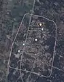
Area overview
The area shown in the adjoining map is the physiographic sub-region known as the diara. It “is a relatively well drained flat land formed by the fluvial deposition of newer alluvium.” The most note-worthy feature is the Farakka Barrage across the Ganges.[4]The area is a part of the Malda Sadar subdivision, which is an overwhelmingly rural region, but the area shown in the map has pockets of urbanization with 17 census towns, concentrated mostly in the Kaliachak I CD block.[5][6]The bank of the Ganges between Bhutni and Panchanandapur (both the places are marked on the map), is the area worst hit by left bank erosion, a major problem in the Malda area.[7]The ruins of Gauda, capital of several empires, is located in this area.[8]
Note: The map alongside presents some of the notable locations in the area. All places marked in the map are linked in the larger full screen map.
Weather
Climate
The accurate weather of Sattari is normally to other places in West Bengal, with a tropical climate, specifically a tropical wet and dry climate(Aw) under the Köppen climate classification, with seven months of dryness and peak of rains in July to October.The cooler season from December to February is followed by the summer season from March to June.RealFeel®: 34° Winds: 7 km/h SEGusts: 11 km/h Humidity: 88%Dew Point: 26° UVIndex: 0(Low)Cloud Cover: 99% Rain: 2 mmSnow: 0 CM Ice: 0mmVisibility: 6 km Ceiling: 9144 mWet Bulb: 27° [9]
Demographics
As of 2011 Indian Census, Sattari had a total population of 10,538, of which 5,458 were males and 5,080 were females, with a sex ratio of 930. Population within the age group of 0 to 6 years was 1,575. The total number of literates in Sattari was 4,977, which constituted 47.2% of the population with male literacy of 52.9% and female literacy of 41.1%. The effective literacy rate of 7+ population of Sattari was 55.5%, of which male literacy rate was 62.0% and female literacy rate was 48.5%. The Scheduled Castes population was 3,043. Sattari had 2318 households in 2011.[1]
Administration
Sattari village is administrated by Binodpur Gram Panchayat (transl. Bindopur village council) of the English Bazar community development block of Malda district. Sattari is the headquarters of the village council and is represented by six of the thirteen seats; four are Muslim and two are Hindu. Sattari falls under the jurisdiction of the English Bazar Police Station.Sattari's four peoples nabs by NIA from Kolkata for possession of fake currency.[10]
| Part name | Part no. | Type |
|---|---|---|
| Natunpara | Part-IX/9 | Most Rural |
| Jarlahipara, Bazarpara | Part-X/10 | Rural |
| Masjidpara | Part-XI/11 | Rural |
| Basantapur, Nimtala | Part-XII/12 | Rural |
| Nagarpara, Tiarpara, Helupara | Part-XIII/13 | Rural |
| Puratan Choudhurypara, Natun Choudhurypara, Khatiyatanga | Part-XIV/14 | Rural |
| Titipara, Dakshin Chandipur | Part-XV/15 | Rural |
| Kagmari Hatpara | Part-XVI/16 | Rural |
Festivals
Almost all of the major religious festivals are celebrated, like
- Durga puja
- Kali Puja
- Diwali
- Eid al-Fitr
- Eid al-Adha
- Muharram
- Milad un-Nabi
- Shab-e-Barat
- Ratha-Yatra
- Maha Shivratri
Fairs
Some of the mostly reputed cultural fairs of the town are .
- Eid Fair, at Sattari Eid Gah Field
- Muharram Fair, at Sattari Karbala Maidan
- Kali Puja Fair, at Kagmari Bridge
Places of interest
Education
Sattari High School is a Bengali-medium coeducational institution established in 1971. It has facilities for teaching from class V to class XII. It has a playground, a library with 2050 books, and 10 computers for teaching and learning purposes.[11]
Transport
Taxi cabs and buses are the best way to get around this city, with public and private bus service available within the town. There are options to rent cars and bicycles. Malda Town railway station is 15.5 kilometres (9.6 mi) away, and there are no local trains.
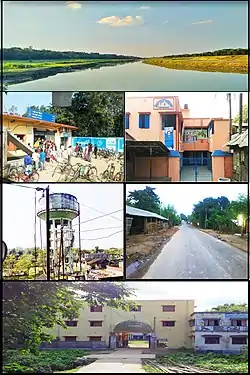
Gallery
 Sattari Satellite view on Google Map
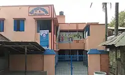 Gram Panchayat Building, Sattari
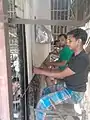 Sattari carpet work
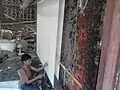 Sattari carpet work
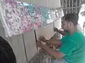 Sattari carpet work
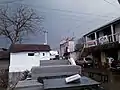 Shop and market parking place
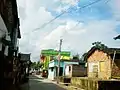 Sattari Village interior Natunpara
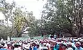 Sattari Eid Ul-fiter Jamad
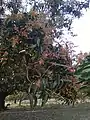 Sattari Mango Tree Garden
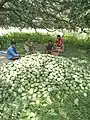 Sattari Mango Garden
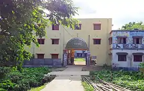 Sattari High School Building
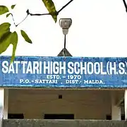
See also
References
- 1 2 "Census of India: Sattari". www.censusindia.gov.in. Retrieved 8 December 2019.
- 1 2 "Fact and Figures". www.wb.gov.in. Retrieved 2 April 2019.
- ↑ "52nd REPORT OF THE COMMISSIONER FOR LINGUISTIC MINORITIES IN INDIA" (PDF). nclm.nic.in. Ministry of Minority Affairs. p. 85. Archived from the original (PDF) on 25 May 2017. Retrieved 2 April 2019.
- ↑ "District Census Handbook Maldah, Series 20, Part XII A" (PDF). Census of India 2011, Pages 13-15: Physiography. Directorate of Census Operations, West Bengal. Retrieved 9 November 2018.
- ↑ "District Statistical Handbook 2014 Malda". Table 2.1 , 2.2, 2.4b. Department of Statistics and Programme Implementation, Government of West Bengal. Retrieved 9 November 2018.
- ↑ "C.D. Block Wise Primary Census Abstract Data(PCA)". West Bengal – District-wise CD Blocks. Registrar General and Census Commissioner, India. Retrieved 9 November 2018.
- ↑ Banerjee, Manisha. "A Report on the Impact of Farakka Barrage on the Human Fabric, November 1999" (PDF). The social impact of erosion, pp 13-14. South Asia Network On Dams, Rivers and People, New Delhi: 110 088 India. Archived from the original (PDF) on 8 August 2017. Retrieved 16 August 2021.
- ↑ "District Human Development Report, Malda". pages 3-4: Malda in Historical Perspective. Department of Planning, Statistics and Programme Monitoring, Government of West Bengal. Retrieved 6 November 2018.
- ↑ "Weather of Sattari Village". m.accuweather.com. Retrieved 11 November 2018.
- ↑ "NIA nabs four from Kolkata for possession of fake curency". www.newindianexpress.com. Retrieved 22 February 2019.
- ↑ "Sattari High School". Schools.org. Retrieved 17 August 2021.
Cities, towns and locations in Malda district, Malda division | ||||||
|---|---|---|---|---|---|---|
| Cities, municipal and census towns |
|  Divisions of West Bengal | ||||
| Locations other than cities and towns |
| |||||
| Neighbourhood | ||||||
| Related topics |
| |||||