| Sape Strait | |
|---|---|
| Selat Sape (Indonesian) | |
 Northeast passage to the Sape Strait at northern tip of Komodo Island. | |
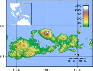 Sape Strait Sumbawa island and Sape Strait | |
| Coordinates | 8°39′00″S 119°18′00″E / 8.65000°S 119.30000°E |
| Type | strait |
| Basin countries | Indonesia |
| References | Selat Sape: Indonesia National Geospatial-Intelligence Agency, Bethesda, MD, USA |
The Sape Strait (Indonesian: Selat Sape) or Sapie Strait[1] is a strait connecting the Flores Sea to the Sumba Strait. It separates the islands of Sumbawa and Komodo. It joins the Indonesian provinces of West Nusa Tenggara and East Nusa Tenggara.
The Sape Strait is known for rough seas, shoals[2] and strong currents, as well as spectacular marine life. The waters of the strait are enjoying growing popularity among diving enthusiasts. [3]
Part of the Sape water area is included in the Komodo National Park, a UNESCO World Heritage Site.

Map of the Sape Strait with the designation of the administrative boundary between the provinces of Western Small Sunda Islands and the Eastern Lesser Sunda Islands
The volcanic islands in the Strait include:
- Sangeang, Banta Island, Matagate Island (administratively part of Sumbawa Regency)
- Komodo Island, Rinca Island (administratively part of East Flores Regency)
Notes
- ↑ Goodall, George (Editor)(1943) Philips' International Atlas London, George Philip and Son map 'East Indies' pp.91-92 for the pre Independence spelling
- ↑ See USS Boise (CL-47)
- ↑ Dive sites in Komodo and Rinca
This article is issued from Wikipedia. The text is licensed under Creative Commons - Attribution - Sharealike. Additional terms may apply for the media files.