Santa Rita | |
|---|---|
Municipality | |
 Santa Rita Location in Honduras | |
| Coordinates: 15°12′N 87°53′W / 15.200°N 87.883°W | |
| Country | Honduras |
| Department | Yoro |
| Area | |
| • Total | 129 km2 (50 sq mi) |
| Population (2023 projection)[1] | |
| • Total | 21,536 |
| • Density | 170/km2 (430/sq mi) |
| Time zone | UTC-6 (Central America) |
Santa Rita is a town and a municipality in the Honduran department of Yoro. The Humuya River passes through it.[2][3]
The town of Santa Rita has a population of 15,230 (2023 calculation).[4]
In 1684, it was a hamlet called Benque La Laguneta. It later became the village of Santa Rita El Negrito. The place was established as a town in 1959 with part of the municipality of El Negrito.
Demographics
At the time of the 2013 Honduras census, Santa Rita municipality had a population of 20,301. Of these, 89.73% were Mestizo, 9.20% White, 0.77% Black or Afro-Honduran, 0.17% Indigenous and 0.12% others.[5]
References
- ↑ Citypopulation.de Population of departments and municipalities in Honduras
- ↑ Efrain V. Molina. "Habilitan paso en el río Humuya de Santa Rita". Diario La Prensa. Retrieved 24 November 2015.
- ↑ Efrain Molina. "Multarán a los que contaminan el río Humuya". Diario La Prensa. Retrieved 24 November 2015.
- ↑ Citypopulation.de Population of cities in Honduras
- ↑ Instituto Nacional de Estadística (INE), bases de datos en línea
Capital: Yoro | ||
| Municipalities | 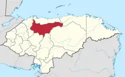 | |
This article is issued from Wikipedia. The text is licensed under Creative Commons - Attribution - Sharealike. Additional terms may apply for the media files.