Santa Catarina Pinula | |
|---|---|
municipality | |
 | |
 Flag | |
| Country | Guatemala |
| Department | Guatemala |
| Municipality | Santa Catarina Pinula |
| Government | |
| • Mayor (2012-2020) | Víctor Alvarizaes Monterroso[1] (PP) |
| Area | |
| • Total | 49.3 km2 (19.0 sq mi) |
| Elevation | 1,640 m (5,380 ft) |
| Population (2018 census)[2] | |
| • Total | 80,582 |
| • Density | 1,600/km2 (4,200/sq mi) |
| Time zone | GMT -6 |
| Climate | Cwb |
| Website | Municipalidad de Santa Catarina Pinula |
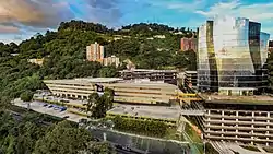
Santa Catarina Pinula is a town, with a population of 70,982 (2018 census)[3] and a municipality in the Guatemala Department of Guatemala. Its name, according to Guatemalan colonial historian Francisco Antonio de Fuentes y Guzmán in his book Recordación Florida comes from:
- Santa Catarina: the name of it saint patron Catherine of Alexandria
- Pinula: from pipil "Flour of water" ("Pinul": Flour of Pinole and "Ha": Water).[4] This may come from the Mexican natives who came alongside Alvarado's forces.[5]
History
The town was originally a native settlement called Pankaj, or Pinola, whose inhabitants presented a strong defense to the conquistadors from Pedro de Alvarado, until they had to finally surrender to the Spanish invaders at the fortified position of Jalpatagua, where they were withdrawn along with the Petapa natives.[6]
Spanish colony
After the Spanish conquest, a town was founded in place of the old native settlement. It soon became one of the most notable settlements in the area, eventually serving as a curato headquarters for the Order of Preachers, which in turn was under the jurisdiction of the Amatitlán convent.[4]
| Convento | Doctrinas | Convento | Doctrinas |
|---|---|---|---|
| Guatemala |
|
Amatitlán | |
| Verapaz | |||
| Sonsonate |
| ||
| San Salvador |
|
Sacapulas |
In 1690, when Fuentes y Guzmán wrote Recordación Florida the town was prosperous and its agriculture was booming, but it was not as well to do if its silver mines had been exploited.[4] Fuentes y Guzmán told the story that, when the church was being built, the workers found a thick silver lining, but they rushed to hide it from the Spaniards, so the latter could not use it.[4]
In 1754, due to a Royal Decree, all the doctrines and curatos still belonging to regular orders were transferred to the secular clergy authorities.[8]
El Cambray II tragedy: 2015
On the night of 1 October 2015 and following several days of heavy rains, a hill collapsed causing a mudslide that destroyed El Cambray II settlement, leaving behind hundreds of missing people, according to the first official reports. Besides, there were nine confirmed deaths, 34 injured and up to 65 displaced on more than 100 destroyed homes.[9] After the landslide, the area was in Code Red.[9]
Administrative organization

The region has a municipal capital (Santa Catarina Pinula), fifteen villages and seven settlements.
|
|
Climate
Santa Catarina Pinula has a subtropical highland climate (Köppen: Cwb).
| Climate data for Santa Catarina Pinula | |||||||||||||
|---|---|---|---|---|---|---|---|---|---|---|---|---|---|
| Month | Jan | Feb | Mar | Apr | May | Jun | Jul | Aug | Sep | Oct | Nov | Dec | Year |
| Mean daily maximum °C (°F) | 23.5 (74.3) |
24.7 (76.5) |
26.1 (79.0) |
26.7 (80.1) |
26.2 (79.2) |
24.4 (75.9) |
24.4 (75.9) |
24.8 (76.6) |
24.2 (75.6) |
23.6 (74.5) |
23.2 (73.8) |
23.2 (73.8) |
24.6 (76.3) |
| Daily mean °C (°F) | 17.7 (63.9) |
18.5 (65.3) |
19.6 (67.3) |
20.5 (68.9) |
20.6 (69.1) |
19.9 (67.8) |
19.8 (67.6) |
19.9 (67.8) |
19.6 (67.3) |
19.1 (66.4) |
18.3 (64.9) |
17.8 (64.0) |
19.3 (66.7) |
| Mean daily minimum °C (°F) | 12.0 (53.6) |
12.3 (54.1) |
13.2 (55.8) |
14.3 (57.7) |
15.1 (59.2) |
15.5 (59.9) |
15.3 (59.5) |
15.1 (59.2) |
15.1 (59.2) |
14.7 (58.5) |
13.4 (56.1) |
12.4 (54.3) |
14.0 (57.3) |
| Average precipitation mm (inches) | 3 (0.1) |
2 (0.1) |
6 (0.2) |
27 (1.1) |
155 (6.1) |
270 (10.6) |
234 (9.2) |
186 (7.3) |
249 (9.8) |
157 (6.2) |
30 (1.2) |
7 (0.3) |
1,326 (52.2) |
| Source: Climate-Data.org[11] | |||||||||||||
Sport
Guatemalan Olympic swimmer Kevin Avila Soto was born here.
Geographic location
Santa Catarina Pinula is completely surrounded by Guatemala Department municipalities:[10]
See also
Notes and references
References
- ↑ "Alcaldes de la zona metropolitana empiezan a definirse". Prensa Libre (in Spanish). Guatemala. 8 September 2015. Retrieved 8 September 2015.
- ↑ Citypopulation.de Population of departments and municipalities in Guatemala
- ↑ Citypopulation.de Population of cities & town in Guatemala
- 1 2 3 4 Fuentes y Guzmán 1883, p. 270.
- ↑ Fuentes y Guzmán 1883, pp. 7–9, 11, 52.
- ↑ Fuentes y Guzmán 1883, pp. 217, 270.
- ↑ Belaubre 2001, p. 39.
- ↑ Juarros 1818, p. 338.
- 1 2 3 4 "Conred: 600 desaparecidos, nueve muertos, 34 heridos y 65 refugiados por tragedia en el Cambray II". ElPeriódico (in Spanish). Guatemala. 2 October 2015. Archived from the original on October 2, 2015. Retrieved 2 October 2015.
- 1 2 3 4 "Municipios del departamento de Guatemala". SEGEPLAN (in Spanish). Guatemala. Archived from the original on 7 July 2015. Retrieved 22 July 2015.
- ↑ "Climate: Santa Catarina Pinula". Climate-Data.org. Retrieved 21 September 2015.
Bibliography
- Belaubre, Christopohe (2001). "Poder y redes sociales en Centroamérica: el caso de la Orden de los Dominicos (1757-1829)" (PDF). Mesoamérica. 41. Archived from the original (PDF) on 21 January 2015.
- Fuentes y Guzmán, Francisco Antonio de (1883) [1690]. Zaragoza, Justo; Navarro, Luis (eds.). Recordación Florida. Discurso historial y demostración natural, material, militar y política del Reyno de Guatemala (in Spanish). Vol. II. Madrid, España: Central.
- Juarros, Domingo (1818). Compendio de la historia de la Ciudad de Guatemala (in Spanish). Guatemala: Ignacio Beteta.
- van Oss, Adriaan C. (1986). Catholic Colonialism: A Parish History of Guatemala, 1524-1821. Cambridge, UK: Cambridge University Press. ISBN 9780521527125.
