Saint-Arsène | |
|---|---|
 | |
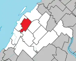 Location within Rivière-du-Loup RCM | |
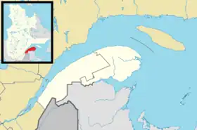 Saint-Arsène Location in eastern Quebec | |
| Coordinates: 47°55′N 69°26′W / 47.917°N 69.433°W[1] | |
| Country | |
| Province | |
| Region | Bas-Saint-Laurent |
| RCM | Rivière-du-Loup |
| Constituted | July 1, 1855 |
| Government | |
| • Mayor | André Roy |
| • Federal riding | Montmagny—L'Islet—Kamouraska—Rivière-du-Loup |
| • Prov. riding | Rivière-du-Loup-Témiscouata |
| Area | |
| • Total | 70.40 km2 (27.18 sq mi) |
| • Land | 70.62 km2 (27.27 sq mi) |
| There is an apparent contradiction between two authoritative sources | |
| Population | |
| • Total | 1,253 |
| • Density | 17.7/km2 (46/sq mi) |
| • Pop 2006-2011 | |
| • Dwellings | 481 |
| Postal code(s) | |
| Area code(s) | 418 and 581 |
| Highways | |
| Website | www |
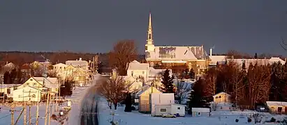
Saint-Arsène (French pronunciation: [sɛ̃.t‿aʁsɛn]) is a parish municipality in Quebec, Canada.
Demographics
In the 2021 Census of Population conducted by Statistics Canada, Saint-Arsène had a population of 1,245 living in 468 of its 479 total private dwellings, a change of 1.2% from its 2016 population of 1,230. With a land area of 70.81 km2 (27.34 sq mi), it had a population density of 17.6/km2 (45.5/sq mi) in 2021.[4]
See also
References
- ↑ "Banque de noms de lieux du Québec: Reference number 55668". toponymie.gouv.qc.ca (in French). Commission de toponymie du Québec.
- 1 2 "Répertoire des municipalités: Geographic code 12065". www.mamh.gouv.qc.ca (in French). Ministère des Affaires municipales et de l'Habitation.
- 1 2 "Saint-Arsène, Quebec (Code 2412065) Census Profile". 2011 census. Government of Canada - Statistics Canada.
- ↑ "Population and dwelling counts: Canada, provinces and territories, and census subdivisions (municipalities), Quebec". Statistics Canada. February 9, 2022. Retrieved August 29, 2022.
External links
 Media related to Saint-Arsène at Wikimedia Commons
Adjacent Municipal Subdivisions | ||||||||||||||||
|---|---|---|---|---|---|---|---|---|---|---|---|---|---|---|---|---|
| ||||||||||||||||
| Cities & Towns | |
|---|---|
| Municipalities | |
| Parishes | |
| |
This article is issued from Wikipedia. The text is licensed under Creative Commons - Attribution - Sharealike. Additional terms may apply for the media files.