 Saint Paul Street in Old Montreal | |
| Native name | Rue Saint-Paul (French) |
|---|---|
| Length | 2 km (1.2 mi) |
| Location | Montreal |
| West end | Montfort Street |
| East end | Berri Street |
| Construction | |
| Inauguration | 1673 |
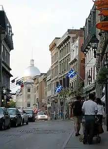

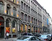
Rue Saint-Paul (Saint Paul Street) is a street in the Old Montreal historic area of Montreal, Quebec.
The street was laid out by François Dollier de Casson, along the route of a path that had bordered a former fort.[1] Saint Paul is Montreal's oldest street and for many years served as its main thoroughfare.[2] Paved in 1672, it was named after Paul de Chomedey de Maisonneuve, founder of Montreal, who built a home for himself on it in 1650.[3]
The street is home to such landmarks as the Bonsecours Market and Notre-Dame-de-Bon-Secours Chapel.[4] Much of Saint Paul is still paved with cobblestones. Plans to pedestrianize the street in 2008 were dropped by the City of Montreal after complaints from merchants.
References
- ↑ Goldman, Norman. "A Summer Walk into Montreal's Early Years under French Rule". Bootsn All Travel. Retrieved 2008-03-02.
- ↑ "Rue Saint Paul". Planetware. Retrieved 2008-03-02.
- ↑ "In the footsteps of Emilie". Sisters of Providence. Archived from the original on September 22, 2008. Retrieved 2008-03-02.
- ↑ "Saint Paul Street, Democracy in Montreal". City of Montreal. Retrieved 2008-03-02.
External links
45°30′19″N 73°33′14″W / 45.505339°N 73.553888°W