Rudan County
Persian: شهرستان رودان | |
|---|---|
County | |
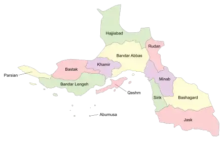 Location of Rudan County in Hormozgan province (top right, pink) | |
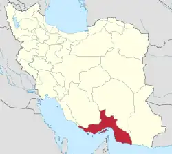 Location of Hormozgan province in Iran | |
| Coordinates: 27°32′N 57°15′E / 27.533°N 57.250°E[1] | |
| Country | |
| Province | Hormozgan |
| Capital | Rudan |
| Districts | Central, Bikah, Jaghin, Rudkhaneh |
| Population (2016) | |
| • Total | 124,522 |
| Time zone | UTC+3:30 (IRST) |
Rudan County (Persian: شهرستان رودان) is in Hormozgan province, Iran. Its capital the city of Rudan.[2]
At the 2006 census, the county's population was 104,222 in 21,923 households.[3] The following census in 2011 counted 118,547 people in 29,066 households.[4] At the 2016 census, the county's population was 124,522 in 34,561 households.[5]
Administrative divisions
The population history and structural changes of Rudan County's administrative divisions over three consecutive censuses are shown in the following table. The latest census shows four districts, 10 rural districts, and three cities.[5]
In September 2017, the village of Balashahr in Jaghin District was elevated to the status of a city.[6] In September 2019, Berentin Rural District was transferred from Bikah District to the Central District, and Eslamabad Rural District was established in Bikah District.[7]
| Administrative Divisions | 2006[3] | 2011[4] | 2016[5] |
|---|---|---|---|
| Central District | 52,816 | 59,660 | 63,616 |
| Abnama RD | 17,855 | 20,662 | 22,271 |
| Berentin RD | |||
| Faryab RD | 2,495 | 3,077 | 2,922 |
| Rahdar RD | 2,406 | 2,636 | 2,302 |
| Rudan (city) | 30,060 | 33,285 | 36,121 |
| Bikah District | 22,532 | 24,540 | 24,606 |
| Berentin RD | 8,328 | 9,032 | 8,684 |
| Bikah RD | 14,204 | 8,506 | 8,732 |
| Eslamabad RD1 | |||
| Bikah (city) | 7,002 | 7,190 | |
| Jaghin District | 11,254 | 15,318 | 14,468 |
| Jaghin-e Jonubi RD | 4,083 | 5,249 | 5,086 |
| Jaghin-e Shomali RD | 7,171 | 10,069 | 9,382 |
| Balashahr (city)2 | |||
| Rudkhaneh District | 17,620 | 19,029 | 21,606 |
| Mosaferabad RD | 5,111 | 5,069 | 6,727 |
| Rudkhaneh RD | 2,572 | 2,643 | 3,338 |
| Rudkhaneh Bar RD | 7,431 | 8,242 | 8,862 |
| Ziarat-e Ali (city) | 2,506 | 3,075 | 2,679 |
| Total | 104,222 | 118,547 | 124,522 |
| RD: Rural District 1Established after the 2016 census[7] 2Formerly the village of Jaghin, became a city after the 2016 census[6] | |||
References
- ↑ OpenStreetMap contributors (12 September 2023). "Rudan County" (Map). OpenStreetMap. Retrieved 12 September 2023.
- ↑ Gitashenasi Province Atlas of Iran
اطلس گیتاشناسی استانهای ایران Archived 2007-05-22 at the Wayback Machine - 1 2 "Census of the Islamic Republic of Iran, 1385 (2006)". AMAR (in Persian). The Statistical Center of Iran. p. 22. Archived from the original (Excel) on 20 September 2011. Retrieved 25 September 2022.
- 1 2 "Census of the Islamic Republic of Iran, 1390 (2011)" (Excel). Iran Data Portal (in Persian). The Statistical Center of Iran. p. 22. Retrieved 19 December 2022.
- 1 2 3 "Census of the Islamic Republic of Iran, 1395 (2016)". AMAR (in Persian). The Statistical Center of Iran. p. 22. Archived from the original (Excel) on 5 May 2022. Retrieved 19 December 2022.
- 1 2 Fazli, Abdolreza Rahmani (21 September 2017). "Notification of the approval of the Ministry of Interior regarding the transformation of Balashahr village, the center of Jaghin District of Rudan County, into a city". DOTIC (in Persian). Ministry of Interior. Archived from the original on 12 September 2023. Retrieved 12 September 2023.
- 1 2 Jahangiri, Ishaq (26 September 2019). "Letter of approval regarding country divisions in Rudan County, Hormozgan province". Qavanin (in Persian). Ministry of Interior, Council of Ministers. Archived from the original on 12 September 2023. Retrieved 12 September 2023.
Hormozgan Province, Iran | |||||||||||||||||||||||||
|---|---|---|---|---|---|---|---|---|---|---|---|---|---|---|---|---|---|---|---|---|---|---|---|---|---|
| Capital |  | ||||||||||||||||||||||||
| Counties and cities |
| ||||||||||||||||||||||||
| Sights |
| ||||||||||||||||||||||||
| populated places | |||||||||||||||||||||||||
| See also | |||||||||||||||||||||||||