Rozseč nad Kunštátem | |
|---|---|
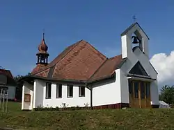 Church of Saint Anthony of Padua | |
 Flag  Coat of arms | |
 Rozseč nad Kunštátem Location in the Czech Republic | |
| Coordinates: 49°31′28″N 16°27′47″E / 49.52444°N 16.46306°E | |
| Country | |
| Region | South Moravian |
| District | Blansko |
| First mentioned | 1350 |
| Area | |
| • Total | 6.13 km2 (2.37 sq mi) |
| Elevation | 628 m (2,060 ft) |
| Population (2023-01-01)[1] | |
| • Total | 559 |
| • Density | 91/km2 (240/sq mi) |
| Time zone | UTC+1 (CET) |
| • Summer (DST) | UTC+2 (CEST) |
| Postal code | 679 73 |
| Website | www |
Rozseč nad Kunštátem is a municipality and village in Blansko District in the South Moravian Region of the Czech Republic. It has about 600 inhabitants.
Rozseč nad Kunštátem lies approximately 22 kilometres (14 mi) north-west of Blansko, 37 km (23 mi) north of Brno, and 160 km (99 mi) south-east of Prague.
References
Wikimedia Commons has media related to Rozseč nad Kunštátem.
This article is issued from Wikipedia. The text is licensed under Creative Commons - Attribution - Sharealike. Additional terms may apply for the media files.