 | |
|---|---|
| Ruta nacional PY08 | |
| Dr. Blas Garay | |
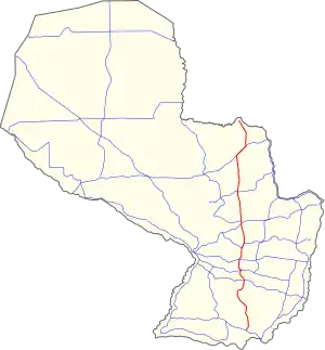 PY08 highlighted in red. | |
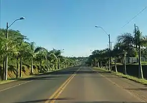 PY08 near the city of Caazapá. | |
| Route information | |
| Length | 320 km (200 mi) |
| Major junctions | |
| North end | San Estanislao |
| |
| South end | Coronel Bogado |
| Location | |
| Country | Paraguay |
| Highway system | |
National Route 8 (officially, Ruta Nacional Número 8 "Dr. Blas Garay", simply known as Ruta Ocho) is a highway in Paraguay, which runs from San Estanislao to Coronel Bogado. It mainly connects the north and the south regions of the Oriental Region of Paraguay. It crosses five departments and has a total length of 320 km.
Distances, cities and towns
The following table shows the distances traversed by National Route 8 in each different department, showing cities and towns that it passes by (or near).
| Km | City | Department | Junctions |
|---|---|---|---|
| 0 | San Estanislao | San Pedro | |
| 20 | Yataity del Norte | San Pedro | |
| 35 | Santa Rosa del Mbutuy | Caaguazú | |
| 44 | Simón Bolívar | Caaguazú | |
| 62 | Carayaó | Caaguazú | |
| 91 | Coronel Oviedo | Caaguazú | |
| 119 | Yataity del Guairá | Guairá | |
| 126 | Mbocayaty | Guairá | |
| 133 | Villarrica | Guairá | |
| 158 | Ñumí | Guairá | |
| 187 | Caazapá | Caazapá | |
| 248 | Yuty | Caazapá | |
| 263 | Leandro Oviedo | Itapúa | |
| 278 | San Pedro del Paraná | Itapúa | |
| 298 | General Artigas | Itapúa | |
| 320 | Coronel Bogado | Itapúa |

This article is issued from Wikipedia. The text is licensed under Creative Commons - Attribution - Sharealike. Additional terms may apply for the media files.