Rokytá | |
|---|---|
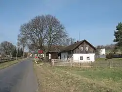 House by road in Horní Rokytá | |
 Flag  Coat of arms | |
 Rokytá Location in the Czech Republic | |
| Coordinates: 50°33′0″N 14°52′42″E / 50.55000°N 14.87833°E | |
| Country | |
| Region | Central Bohemian |
| District | Mladá Boleslav |
| First mentioned | 1356 |
| Area | |
| • Total | 10.60 km2 (4.09 sq mi) |
| Elevation | 293 m (961 ft) |
| Population (2023-01-01)[1] | |
| • Total | 359 |
| • Density | 34/km2 (88/sq mi) |
| Time zone | UTC+1 (CET) |
| • Summer (DST) | UTC+2 (CEST) |
| Postal code | 295 01 |
| Website | www |
Rokytá is a municipality in Mladá Boleslav District in the Central Bohemian Region of the Czech Republic. It has about 400 inhabitants.
Administrative parts
The municipality is made up of villages of Dolní Rokytá and Horní Rokytá.
References
Wikimedia Commons has media related to Rokytá.
This article is issued from Wikipedia. The text is licensed under Creative Commons - Attribution - Sharealike. Additional terms may apply for the media files.