| Roaring River[1] | |
|---|---|
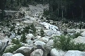 The Roaring River meets the alluvial fan created by the Lawn Lake flood of 1982 | |
| Physical characteristics | |
| Source | |
| • coordinates | 40°28′15″N 105°38′48″W / 40.47083°N 105.64667°W |
| • elevation | 11,519 ft (3,511 m) |
| Mouth | |
• location | Confluence with Fall River |
• coordinates | 40°24′34″N 105°38′13″W / 40.40944°N 105.63694°W |
• elevation | 8,563 ft (2,610 m) |
| Basin features | |
| Progression | Fall—Big Thompson— South Platte—Platte— Missouri—Mississippi |
The Roaring River is a 6.5-mile-long (10.5 km)[2] tributary of the Fall River in Larimer County, Colorado. The river's source is Crystal Lake in the Mummy Range of Rocky Mountain National Park The river flows through Lawn Lake before a confluence with the Fall River in Horseshoe Park. The collapse of the Lawn Lake Dam in 1982 scoured the river's channel and deposited an alluvial fan of debris in Horseshoe Park.[3]
See also
References
- ↑ "Roaring River". Geographic Names Information System. United States Geological Survey, United States Department of the Interior. Retrieved 2011-02-03.
- ↑ U.S. Geological Survey. National Hydrography Dataset high-resolution flowline data. The National Map, accessed March 25, 2011
- ↑ "The Lawn Lake Flood". Town of Estes Park. Archived from the original on December 9, 2011.
This article is issued from Wikipedia. The text is licensed under Creative Commons - Attribution - Sharealike. Additional terms may apply for the media files.