Richecourt | |
|---|---|
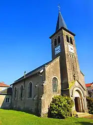 The church in Richecourt | |
 Coat of arms | |
Location of Richecourt | |
 Richecourt  Richecourt | |
| Coordinates: 48°52′50″N 5°45′43″E / 48.8806°N 5.7619°E | |
| Country | France |
| Region | Grand Est |
| Department | Meuse |
| Arrondissement | Commercy |
| Canton | Saint-Mihiel |
| Intercommunality | CC Côtes de Meuse Woëvre |
| Government | |
| • Mayor (2020–2026) | Francine Zins[1] |
| Area 1 | 6.23 km2 (2.41 sq mi) |
| Population | 56 |
| • Density | 9.0/km2 (23/sq mi) |
| Time zone | UTC+01:00 (CET) |
| • Summer (DST) | UTC+02:00 (CEST) |
| INSEE/Postal code | 55431 /55300 |
| Elevation | 223–243 m (732–797 ft) (avg. 239 m or 784 ft) |
| 1 French Land Register data, which excludes lakes, ponds, glaciers > 1 km2 (0.386 sq mi or 247 acres) and river estuaries. | |
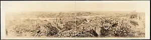
World War I damage at Richecourt
Richecourt (French pronunciation: [ʁiʃkuʁ]) is a commune in the Meuse department in Grand Est in north-eastern France.
Geography
The village lies on the left bank of the Rupt de Mad, which flows northeastward through the south-eastern part of the commune.
See also
References
- ↑ "Répertoire national des élus: les maires" (in French). data.gouv.fr, Plateforme ouverte des données publiques françaises. 13 September 2022.
- ↑ "Populations légales 2021". The National Institute of Statistics and Economic Studies. 28 December 2023.
Wikimedia Commons has media related to Richecourt (Meuse).
This article is issued from Wikipedia. The text is licensed under Creative Commons - Attribution - Sharealike. Additional terms may apply for the media files.