Radějovice | |
|---|---|
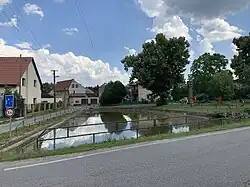 Centre of Radějovice | |
_-_Flag.png.webp) Flag _-_CoA.png.webp) Coat of arms | |
 Radějovice Location in the Czech Republic | |
| Coordinates: 49°56′50″N 14°33′53″E / 49.94722°N 14.56472°E | |
| Country | |
| Region | Central Bohemian |
| District | Prague-East |
| First mentioned | 1227 |
| Area | |
| • Total | 5.09 km2 (1.97 sq mi) |
| Elevation | 412 m (1,352 ft) |
| Population (2023-01-01)[1] | |
| • Total | 532 |
| • Density | 100/km2 (270/sq mi) |
| Time zone | UTC+1 (CET) |
| • Summer (DST) | UTC+2 (CEST) |
| Postal code | 251 68 |
| Website | www |
Radějovice is a municipality and village in Prague-East District in the Central Bohemian Region of the Czech Republic. It has about 500 inhabitants.
Administrative parts
The village of Olešky is an administrative part of Radějovice.
Geography
Radějovice is located about 10 km (6 mi) southeast of Prague. It lies in the Benešov Uplands.
History
The first written mention of Radějovice is from 1227. In 1228, the village was documented as the possession of the Benedictine St. George's Convent at Prague Castle. Then the village was divided into several parts, owned by different nobles. This state lasted for several centuries until the establishment of a sovereign municipality in 1848.[2]
Sights

The main landmark is the Church of the Nativity of the Virgin Mary, located in Olešky. It was built in the Romanesque style in the first half of the 13th century, later it was gothic and baroque rebuilt.[3]
References
- ↑ "Population of Municipalities – 1 January 2023". Czech Statistical Office. 2023-05-23.
- ↑ "Radějovice" (in Czech). Obec Radějovice. Retrieved 2023-06-06.
- ↑ "Kostel Narození Panny Marie" (in Czech). National Heritage Institute. Retrieved 2023-06-06.