Räbke | |
|---|---|
 Coat of arms | |
Location of Räbke within Helmstedt district 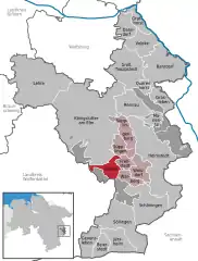 | |
 Räbke 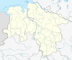 Räbke | |
| Coordinates: 52°12′N 10°53′E / 52.200°N 10.883°E | |
| Country | Germany |
| State | Lower Saxony |
| District | Helmstedt |
| Municipal assoc. | Nord-Elm |
| Government | |
| • Mayor | Rainer Angerstein |
| Area | |
| • Total | 11.35 km2 (4.38 sq mi) |
| Elevation | 134 m (440 ft) |
| Population (2021-12-31)[1] | |
| • Total | 740 |
| • Density | 65/km2 (170/sq mi) |
| Time zone | UTC+01:00 (CET) |
| • Summer (DST) | UTC+02:00 (CEST) |
| Postal codes | 38375 |
| Dialling codes | 05355 |
| Vehicle registration | HE |
| Website | www.raebke.de |
Räbke is a municipality in the district of Helmstedt, in Lower Saxony, Germany. It is part of the collective municipality (Samtgemeinde) of Nord-Elm. The village is situated north of the wooded Elm hill range at the Schunter river.
The settlement was first mentioned as Ridepe in a 1205 deed. Since the 16th century Räbke was known for its paper mills meeting the needs of the University of Helmstedt.
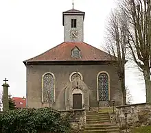
The Lutheran church
References
Towns and municipalities in Helmstedt (district) | ||
|---|---|---|
Coat of arms | ||
This article is issued from Wikipedia. The text is licensed under Creative Commons - Attribution - Sharealike. Additional terms may apply for the media files.