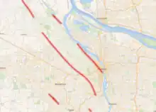
Portland Hills Fault using data from USGS and OpenStreetMap. Made using QGIS
The Portland Hills fault zone is the largest shallow fault that cuts beneath Portland, Oregon.[1] It stretches from Oregon City to Scappoose, and has a zone of deformation that extends at least 1,300 feet (400 m).[2]
References
- ↑ Joe Rojas-Burke (February 23, 2011). "Comparing Portland's quake risk to that of devastated Christchurch, New Zealand". The Oregonian.
- ↑ Liberty, Lee M; Hemphill-Haley, Mark A; Madin, Ian P (2003). "The Portland Hills Fault: uncovering a hidden fault in Portland, Oregon using high-resolution geophysical methods". Tectonophysics. 368 (1–4): 89–103. Bibcode:2003Tectp.368...89L. doi:10.1016/S0040-1951(03)00152-5.
This article is issued from Wikipedia. The text is licensed under Creative Commons - Attribution - Sharealike. Additional terms may apply for the media files.