| Portal | WikiProject Rivers | Talk page |
Introduction
A river is a natural flowing watercourse, usually a freshwater stream, flowing on the earth's land surface or inside caves towards another waterbody at a lower elevation, such as an ocean, sea, bay, lake, wetland, or another river. In some cases, a river flows into the ground or becomes dry at the end of its course without reaching another body of water. Small rivers can be referred to by names such as creek, brook, and rivulet. There are no official definitions for the generic term river as applied to geographic features, although in some countries or communities, a stream is defined by its size. Many names for small rivers are specific to geographic location; examples are "run" in some parts of the United States, "burn" in Scotland and Northeast England, and "beck" in Northern England. Sometimes a river is defined as being larger than a creek, but not always; the language is vague.
Rivers are an important part of the water cycle. Water from a drainage basin generally collects into a river through surface runoff from precipitation, meltwater released from natural ice and snowpacks, and other underground sources such as groundwater recharge and springs. Rivers are often considered major features within a landscape; however, they actually only cover around 0.1% of the land on Earth. Rivers are also an important natural terraformer, as the erosive action of running water carves out rills, gullies, and valleys in the surface as well as transferring silt and dissolved minerals downstream, forming river deltas and islands where the flow slows down. As a waterbody, rivers also serve crucial ecological functions by providing and feeding freshwater habitats for aquatic and semiaquatic fauna and flora, especially for migratory fish species, as well as enabling terrestrial ecosystems to thrive in the riparian zones.
Rivers are significant to humankind since many human settlements and civilizations are built around sizeable rivers and streams. Most of the major cities of the world are situated on the banks of rivers, as they are (or were) depended upon as a vital source of drinking water, for food supply via fishing and agricultural irrigation, for shipping, as natural borders and/or defensive terrains, as a source of hydropower to drive machinery or generate electricity, for bathing, and as a means of disposing of waste. In the pre-industrial era, larger rivers were a major obstacle to the movement of people, goods, and armies across regions. Towns often developed at the few locations suitable for fording, building bridges, or supporting ports; many major cities, such as London, are located at the narrowest and most reliable sites at which a river could be crossed via bridges or ferries. (Full article...)
Selected article -

The U.S. state of Texas has a series of estuaries along its coast on the Gulf of Mexico, most of them bounded by the Texas barrier islands. Estuaries are coastal bodies of water in which freshwater from rivers mixes with saltwater from the sea. Twenty-one drainage basins terminate along the Texas coastline, forming a chain of seven major and five minor estuaries: listed from southwest to northeast, these are the Rio Grande Estuary, Laguna Madre, the Nueces Estuary (Corpus Christi Bay), the Mission–Aransas Estuary (Aransas Bay), the Guadalupe Estuary (San Antonio Bay), the Colorado–Lavaca Estuary (Matagorda Bay), East Matagorda Bay, the San Bernard River and Cedar Lakes Estuary, the Brazos River Estuary, Christmas Bay, the Trinity–San Jacinto Estuary (Galveston Bay), and the Sabine–Neches Estuary (Sabine Lake). Each estuary is named for its one or two chief contributing rivers, excepting Laguna Madre, East Matagorda Bay, and Christmas Bay, which have no major river sources. The estuaries are also sometimes referred to by the names of their respective primary or central water bodies, though each also includes smaller secondary bays, inlets, or other marginal water bodies.
These water bodies include some of the largest and most ecologically productive coastal estuaries in the United States and contribute significantly to the ecological and economic resources of Texas. They are included in a number of national protected areas such as National Wildlife Refuges, a National Seashore, and a National Estuarine Research Reserve, as well as various state parks and other regional protected areas. The two most economically important (the Nueces and Trinity–San Jacinto Estuaries) have been designated by the United States Environmental Protection Agency as estuaries of national significance under the National Estuary Program. The Gulf Intracoastal Waterway runs through each of the major estuaries, linking Texas ports with others along the Gulf Coast of the United States. (Full article...)Selected Quote
Selected picture
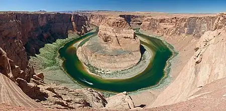
Horseshoe Bend is a horseshoe-shaped meander of the Colorado River in the Glen Canyon National Recreation Area, located 5 miles (8 km) downstream from the Glen Canyon Dam and Lake Powell, near the town of Page, Arizona. It is accessible via hiking trail or an access road.
General images -
 Pondweed is an autochthonous energy source. (from River ecosystem)
 Co-occurrence network of a bacterial community in a stream (from River ecosystem)
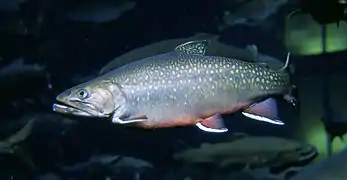 The brook trout is native to small streams, creeks, lakes, and spring ponds. (from River ecosystem)
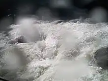 Whitewater at Yosemite (from Whitewater)
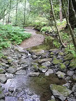 This stream operating together with its environment can be thought of as forming a river ecosystem. (from River ecosystem)
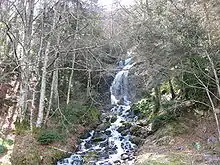 Cascade in the Pyrénées (from River ecosystem)
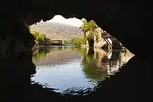
 Devil's Throat Cave subterranean river from above (from Subterranean river)
 A subterranean river in the Cross Cave system of Slovenia. (Scale shown by people in photograph.) (from Subterranean river)
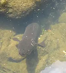 New Zealand longfin eels can weigh over 50 kilograms. (from River ecosystem)
 Flowing rivers can act as dispersal vectors for plant matter and invertebrates. (from River ecosystem)
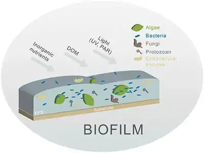 Different biofilm components in streams. Principal components are algae and bacteria. (from River ecosystem)
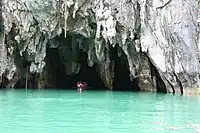 The Puerto Princesa cave can be entered by boat. (from Subterranean river)
 The Effra is one of the subterranean rivers of London. It empties into the Thames by Vauxhall Bridge, from which this photograph was taken. (from Subterranean river)
 Example of a river food web. Bacteria can be seen in the red box at the bottom. Bacteria (and other decomposers, like worms) decompose and recycle nutrients back to the habitat, which is shown by the light blue arrows. Without bacteria, the rest of the food web would starve, because there would not be enough nutrients for the animals higher up in the food web. The dark orange arrows show how some animals consume others in the food web. For example, lobsters may be eaten by humans. The dark blue arrows represent one complete food chain, beginning with the consumption of algae by the water flea, Daphnia, which is consumed by a small fish, which is consumed by a larger fish, which is at the end consumed by the great blue heron. (from River ecosystem)
.jpg.webp) Rafting is a watersport where buoyancy aids, helmets and wetsuits are mandatory and often imposed by law, due to the constant risk of falling off the boat and into the rapids (from Whitewater)
Rafting is a watersport where buoyancy aids, helmets and wetsuits are mandatory and often imposed by law, due to the constant risk of falling off the boat and into the rapids (from Whitewater)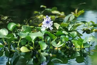 Common water hyacinth in flower (from River ecosystem)
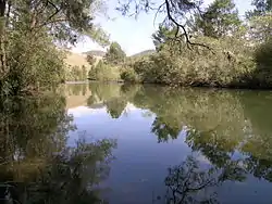 A pensive Cooplacurripa River, NSW (from River ecosystem)
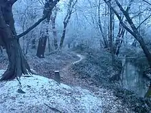 A forest stream in the winter near Erzhausen, Germany (from River ecosystem)
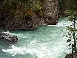 Rapids in Mount Robson Provincial Park (from River ecosystem)
 Leaf litter is an allochthonous energy source. (from River ecosystem)
 Periphyton (from River ecosystem)
.jpg.webp) In Dante's Inferno, Charon ferries souls across the subterranean river Acheron. (from Subterranean river)
In Dante's Inferno, Charon ferries souls across the subterranean river Acheron. (from Subterranean river)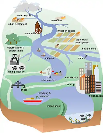 Anthropogenic influences on river systems. Examples are mainly from settings with a modest technological influence, especially in the period of about 10,000 to 4000 cal yr BP. (from River ecosystem)
 The cave of source of the Buna can be entered by boat and dived through a cave system serving as an effluence of the Zalomka. (from Subterranean river)
Did you know?
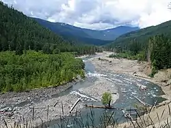
- ... that the Kettle Creek (pictured) watershed contains eight percent of the Class A Wild Trout Streams in Pennsylvania?
- ... that water from the Little Applegate River was used in the mine in Sterlingville, the largest hydraulic mine in Oregon and possibly the entire western United States?
- ... that there are at least 35 sources of acid mine drainage in the Mahanoy Creek watershed?
Related portals
Selected Panorama
Topics
| Large-scale features | |
|---|---|
| Alluvial rivers | |
| Bedrock river | |
| Bedforms | |
| Regional processes | |
| Mechanics | |
| |
Subcategories
Quality content
| This is a list of recognized content, updated weekly by JL-Bot (talk · contribs) (typically on Saturdays). There is no need to edit the list yourself. If an article is missing from the list, make sure it is tagged (e.g. {{WikiProject Rivers}}) or categorized correctly and wait for the next update. See WP:RECOG for configuration options. |
Featured articles
 Aliso Creek (Orange County)
- Balch Creek
- Big Butte Creek
- Bull Run River (Oregon)
- Chetco River
- Colorado River
- Columbia River
- Columbia Slough
- Fanno Creek
- Johnson Creek (Willamette River tributary)
- Jordan River (Utah)
- Little Butte Creek
- Plunketts Creek (Loyalsock Creek tributary)
- River Parrett
- Rogue River (Oregon)
- St. Johns River
- Tryon Creek
- Waterfalls in Ricketts Glen State Park
- White Deer Hole Creek
- Willamette River
Featured lists
- List of longest rivers of the United States (by main stem)
- List of longest streams of Idaho
- List of longest streams of Oregon
- List of tributaries of Bowman Creek
- List of tributaries of Catawissa Creek
- List of tributaries of Larrys Creek
- List of tributaries of Mahanoy Creek
- List of tributaries of Shamokin Creek
Good articles
 1886 St. Croix River log jam
- Abrahams Creek
- Adams River (British Columbia)
- River Avon, Bristol
- Big Wapwallopen Creek
- Black Creek (Susquehanna River tributary)
- Briar Creek (Susquehanna River tributary)
- Brunswick Falls
- Buffalo Creek (West Branch Susquehanna River tributary)
- Canajoharie Creek
- Catawissa Creek
- Celilo Falls
- Cem (river)
- Cibolo Creek
- Covering of the Senne
- Darby Creek (Pennsylvania)
- Eddy Creek (Lackawanna River tributary)
- Esopus Creek
- Estuaries of Texas
- Everglades
- Fishing Creek (North Branch Susquehanna River tributary)
- Flushing River
- Fonteyn Kill
- Fossil Creek
- River Frome, Bristol
- Gowanus Canal
- Great Zab
- Hammersley Fork
- Harveys Creek
- Hudson River
- Hull Creek (Lackawanna River tributary)
- River Hull
- Hunlock Creek
- River Irwell
- Islais Creek
- Ithan Creek
- Jiloca (river)
- Kaweah River
- Kettle Creek (Pennsylvania)
- Keyser Creek
- Kings River (California)
- Kissena Creek
- Klamath River
- Kootenay River
- Laguna Canyon
- Leggetts Creek
- Little Applegate River
- Little Catawissa Creek
- Little Fishing Creek
- Little Wapwallopen Creek
- Mahanoy Creek
- Mahoning Creek (Susquehanna River tributary)
- Meadow Brook (Lackawanna River tributary)
- Merced River
- Messers Run
- Minetta Creek
- Minnehaha Park (Minneapolis)
- Missouri River
- Moston Brook
- Mud Creek (Chillisquaque Creek tributary)
- Muncy Creek
- Nanticoke Creek
- Neepaulakating Creek
- Nescopeck Creek
- Ombla
- Petitcodiac River
- Potlatch River
- River Arun
- River Brue
- River Tone
- River Torrens
- River Weaver
- Roaring Brook (Lackawanna River tributary)
- Roaring Creek (Pennsylvania)
- River Rother, East Sussex
- River Rother, West Sussex
- San Juan Creek
- Santa Ana River
- Sava
- Saw Mill River
- Scotch Run (Catawissa Creek tributary)
- Severn bore
- Shickshinny Creek
- Shimna River
- Shinano River
- Snake River
- Solomon Creek
- Spring Brook (Lackawanna River tributary)
- Stafford Meadow Brook
- Stanislaus River
- Stikine River
- Stony Brook (Charles River tributary, Boston)
- Sulphur Creek (California)
- Tangascootack Creek
- Toby Creek
- Trinity River (California)
- River Trym
- Twomile Run
- Wainui Falls
- River Welland
- West Branch Fishing Creek
- West Creek (Pennsylvania)
- West Kill
- River Witham
- Yellala Falls
- Zarqa River
Things to do

- Join WikiProject Rivers
- Help select future pictures and articles.
- Add items to Did You Know?
- Add the portal link to the top of the See Also section of all relevant pages. This can be done by adding
{{Portal|Rivers}}immediately under the section header.
Associated Wikimedia
The following Wikimedia Foundation sister projects provide more on this subject:
-
 Commons
Free media repository -
 Wikibooks
Free textbooks and manuals -
 Wikidata
Free knowledge base -
 Wikinews
Free-content news -
 Wikiquote
Collection of quotations -
 Wikisource
Free-content library -
 Wikiversity
Free learning tools -
 Wikivoyage
Free travel guide -
 Wiktionary
Dictionary and thesaurus
More portals
-
 List of all portals
 -

-

-

-
-

-

-

-

-

-
 Random portal
 -
 WikiProject Portals