The Oxfordshire Portal

Oxfordshire (/ˈɒksfədʃər, -ʃɪər/ OKS-fahd-shər, -sheer; abbreviated Oxon) is a ceremonial county in South East England. The county is bordered by Northamptonshire and Warwickshire to the north, Buckinghamshire to the east, Berkshire to the south, and Wiltshire and Gloucestershire to the west. The city of Oxford is the largest settlement and county town.
The county is largely rural, with an area of 2,605 km2 (1,006 sq mi) and a population of 691,667. After Oxford (162,100), the largest settlements are Banbury (54,355) and Abingdon-on-Thames (37,931). For local government purposes Oxfordshire is a non-metropolitan county with five districts. The part of the county south of the River Thames, largely corresponding to the Vale of White Horse district, was historically part of Berkshire.
The lowlands in the centre of the county are crossed by the River Thames and its tributaries, the valleys of which are separated by low hills. The south contains parts of the Berkshire Downs and Chiltern Hills, and the north-west includes part of the Cotswolds; all three regions are Areas of Outstanding Natural Beauty. The county's highest point is White Horse Hill (261-metre (856 ft)), part of the Berkshire Downs. (Full article...)
Selected article
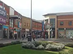
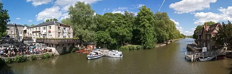
Didcot (/ˈdɪdkɒt, -kət/ DID-kot, -kət) is a railway town and civil parish in the ceremonial county of Oxfordshire and the historic county of Berkshire. Didcot is 15 miles (24 km) south of Oxford, 10 miles (16 km) east of Wantage and 15 miles (24 km) north west of Reading. The town is noted for its railway heritage, Didcot station opening as a junction station on the Great Western Main Line in 1844. Today the town is known for the railway museum and power stations, and is the gateway town to the Science Vale: three large science and technology centres in the surrounding villages of Milton (Milton Park), Culham (Culham Science Centre) and Harwell (Harwell Science and Innovation Campus which includes the Rutherford Appleton Laboratory). (Full article...)
Selected biography

Martin Raymond Keown (/ˈkiːoʊn/; born 24 July 1966) is an English football pundit and former professional footballer who played as a defender from 1984 to 2005, notably in the Premier League for Arsenal, where he made over 400 appearances for the club and won ten honours.
He also played for Brighton & Hove Albion, Aston Villa, Everton, Leicester City and Reading. Keown made his England debut in 1992 against France and went on to win 43 caps for the national side over the next ten years, gradually forming a respected defensive partnership with Arsenal teammate Tony Adams at both club and international level. Keown represented England at four major international football finals including the 1998 and 2002 World Cups, as well as Euro 1992 and Euro 2000.
He is now a part-time scout and coach for Arsenal, as well as a pundit for the BBC and BT Sport. He came out of retirement in 2012 and briefly played for Combined Counties League Premier Division side Wembley in their FA Cup fixtures. (Full article...)
Topics
Selected images
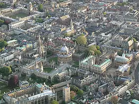 Aerial view of Oxford city centre (from Portal:Oxfordshire/Selected pictures)
- The Radcliffe Camera in Oxford, as viewed from the tower of the Church of St Mary the Virgin. (from Portal:Oxfordshire/Selected pictures)
 Oxford skyline from the University Church of St Mary the Virgin (from Portal:Oxfordshire/Selected pictures)
 Oxford skyline from the University Church of St Mary the Virgin (from Portal:Oxfordshire/Selected pictures)
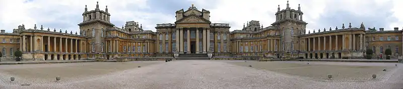 Panoramic view of Blenheim Palace (from Portal:Oxfordshire/Selected pictures)
Subcategories
Things to do
Find references for: A420 road | Abingdon, Oxfordshire | Abingdon School | Anthony Kitchin | Banbury | Banbury mutiny | Bicester | Bicester Community College | Blowing Stone | Boris Johnson | Brakspear | Brenda Rawnsley | Chiltern Main Line | Clanfield F.C. | Colin Greenwood | Debagging | Deddington | Degrees of the University of Oxford | Edward, the Black Prince | Edward the Confessor | European route E5
Expand: A4260 road | Alvescot | Appleton, Oxfordshire | Appleton-with-Eaton | Ardington | Ardington Wick | Arms of the University of Oxford | Ascott Earl | Ascott d'Oyley | Ashbury, Oxfordshire | Aston Rowant | Aston Upthorpe | Baldon Row | Balscote
Create: Banbury Cross Retail Park | Banbury Golf Club
WikiProjects
- Wikipedia:WikiProject University of Oxford
- Wikipedia:WikiProject England
- Wikipedia:WikiProject UK Waterways
- Wikipedia:WikiProject UK geography
Related portals
Associated Wikimedia
The following Wikimedia Foundation sister projects provide more on this subject:
-
 Commons
Free media repository -
 Wikibooks
Free textbooks and manuals -
 Wikidata
Free knowledge base -
 Wikinews
Free-content news -
 Wikiquote
Collection of quotations -
 Wikisource
Free-content library -
 Wikiversity
Free learning tools -
 Wikivoyage
Free travel guide -
 Wiktionary
Dictionary and thesaurus
-
 List of all portals
 -

-

-

-

-

-

-

-

-

-
 Random portal
 -
 WikiProject Portals