| Piz Mitgel | |
|---|---|
 View from Riom-Parsonz (western side) | |
| Highest point | |
| Elevation | 3,159 m (10,364 ft)[1] |
| Prominence | 447 m (1,467 ft)[2] |
| Parent peak | Corn da Tinizong |
| Isolation | 1.93 km (1.20 mi) |
| Listing | Alpine mountains above 3000 m |
| Coordinates | 46°36′51.3″N 9°38′47.7″E / 46.614250°N 9.646583°E |
| Geography | |
 Piz Mitgel Location in Switzerland | |
| Location | Graubünden, Switzerland |
| Parent range | Albula Range |
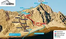
Piz Mitgel is a mountain in the Albula Range of the Swiss Alps, overlooking Savognin, in the canton of Graubünden. Similarly to its higher neighbor, Corn da Tinizong, it has an almost vertical south face. A via ferrata (Senda Ferrada) leads to the summit.
Routes to the summit
References
- ↑ Swisstopo map
- ↑ Google Earth
External links
 Media related to Piz Mitgel at Wikimedia Commons
- Piz Mitgel on Hikr
- Piz Mitgel on Summitpost
This article is issued from Wikipedia. The text is licensed under Creative Commons - Attribution - Sharealike. Additional terms may apply for the media files.