Penokee, Kansas | |
|---|---|
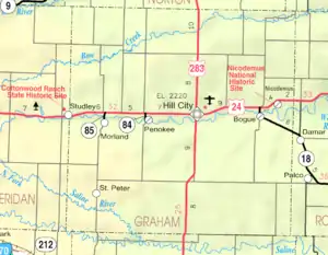 KDOT map of Graham County (legend) | |
 Penokee  Penokee | |
| Coordinates: 39°21′4″N 99°58′20″W / 39.35111°N 99.97222°W[1] | |
| Country | United States |
| State | Kansas |
| County | Graham |
| Founded | 1880s |
| Platted | 1888 |
| Elevation | 2,225 ft (678 m) |
| Time zone | UTC-6 (CST) |
| • Summer (DST) | UTC-5 (CDT) |
| ZIP code | 67659[2] |
| Area code | 785 |
| FIPS code | 20-55375 [1] |
| GNIS ID | 472354 [1] |
Penokee is an unincorporated community in Graham County, Kansas, United States,[1] in the Solomon Valley.
History
The community was originally named Reford and platted in 1888 when the railroad was extended to that point.[3] Because the town became mistaken for Rexford, Kansas, the residents renamed their town after the Penokee Mountains near Lake Superior.
Education
The community is served by Graham County USD 281 public school district.
References
- 1 2 3 4 5 "Penokee, Kansas", Geographic Names Information System, United States Geological Survey, United States Department of the Interior
- ↑ "Penokee ZIP Code". zipdatamaps.com. 2022. Retrieved November 11, 2022.
- ↑ "Origin of Town Names" (PDF). Solomon Valley Highway 24 Heritage Alliance. p. 5. Retrieved April 9, 2018.
Further reading
External links
Municipalities and communities of Graham County, Kansas, United States | ||
|---|---|---|
| Cities | 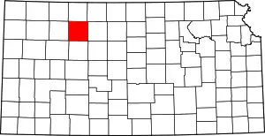 Map of Kansas highlighting Graham County | |
| Unincorporated communities | ||
| Ghost towns | ||
| Townships | ||
| Footnotes | †This community is designated a Census-Designated Place (CDP) by the United States Census Bureau. | |
This article is issued from Wikipedia. The text is licensed under Creative Commons - Attribution - Sharealike. Additional terms may apply for the media files.