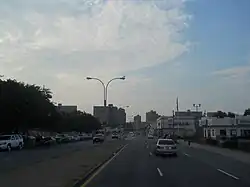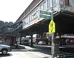

Pennsylvania Avenue is a major north–south street in Brooklyn, New York. It generally runs north to south, from the Jackie Robinson Parkway in Broadway Junction to the Belt Parkway in Starrett City.
Pennsylvania Avenue is also known as Granville Payne Avenue, named after a jazz musician and community activist.[1]
Transportation
The New York City Subway's IRT New Lots Line (2, 3, 4, and 5 trains) has a station at the intersection of Pennsylvania Avenue and Livonia Avenue. The IND Fulton Street Line (A and C trains) has a stop at the intersection of Pennsylvania and Liberty Avenues. The B20, B82, and B83 buses also serve a portion of the avenue.
Route
From the Linden Boulevard intersection to the Belt Parkway junction, Pennsylvania Avenue has three lanes in each direction, with a concrete median and a center lane for left turns at some intersections. The segment between Linden Boulevard and the Jackie Robinson Parkway has three lanes in each direction, but no median.
Exit 14 on the Belt Parkway is the southern terminus of Pennsylvania Avenue.[2] In 2019, the southern end of Pennsylvania Avenue was extended as the entrance to Shirley Chisholm State Park, built atop a decommissioned landfill facing Jamaica Bay.
Mall
In 2000, construction took place nearby Pennsylvania Avenue, across the Hendrix Creek in East New York to build a $192 million shopping complex, situated on the Belt Parkway. The shopping complex, known as the Gateway Center, was built on the Pennsylvania Avenue and Fountain Avenue Landfills, a 230-acre (0.93 km2) Brooklyn landfill complex. Anchor tenants of the 640,000-square-foot (59,000 m2) mall include Target, Home Depot, BJ's Wholesale Club, Marshalls and Bed Bath & Beyond. Restaurants, including Red Lobster and Olive Garden, are also part of the Gateway Center. Construction of Gateway Estates, a low income housing subdivision nearby, took place after the shopping mall opened in 2002. Due to the mall's location near roads with high traffic volume, including Pennsylvania Avenue, Erskine Street, Flatlands Avenue, and the Belt Parkway, local developers said it will attract shoppers from areas outside of Brooklyn, including Queens and Long Island. This development has been a significant project for economic resurrection and has created many jobs for people in the neighborhood of East New York.[3]
References
- ↑ "Some selected Brooklyn Street & Place Name Origins..." Brooklyn.com. Archived from the original on November 3, 2008. Retrieved July 12, 2011.
- ↑ "1943 Profile of the Spring Creek Basin, Brooklyn area from the 1943 New York City Market Analysis" (PDF). 1940snewyork.com. Center for Urban Research at the CUNY Graduate Center, The New York Times, New York Daily Mirror, Hearst Corporation. Retrieved November 18, 2015.
- ↑ Nichole M. Christian (November 15, 2000). "East New York Senses Promise In a New Mall". The New York Times. Retrieved July 12, 2011.