Pasangkayu Regency | |
|---|---|
 Coat of arms | |
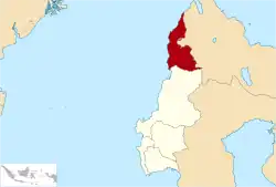 Location within West Sulawesi | |
| Coordinates: 1°19′05″S 119°22′30″E / 1.3181°S 119.3751°E | |
| Country | Indonesia |
| Province | West Sulawesi |
| Capital | Pasangkayu |
| Government | |
| • Regent | Agus Ambo Djiwa |
| • Vice Regent | Muhammad Saal |
| Area | |
| • Total | 1,175.20 sq mi (3,043.75 km2) |
| Population (mid 2022 estimate) | |
| • Total | 198,608 |
| • Density | 170/sq mi (65/km2) |
| [1] | |
| Time zone | UTC+8 (ICST) |
| Postcode | 91571 |
| Area code | (+62) 457 |
| Website | pasangkayukab.go.id |
Pasangkayu Regency (Indonesian: Kabupaten Pasangkayu) is one of the six regencies which comprise West Sulawesi Province, Indonesia, on the island of Sulawesi. It covers an area of 3,043.75 km2 and had a population of 134,303 at the 2010 Census[2] and 188,861 at the 2020 Census.[3] The official estimate as at mid 2022 was 198,608 (comprising 102,945 males and 95,663 females).[1] The town of Pasangkayu is the capital and chief town of the regency.
History
The regency was initially named North Mamuju Regency from its creation on 25 February 2003 (from the former northern districts of Mamuju Regency), until it was renamed as Pasangkayu Regency in March 2018.[4]
Administrative districts
The regency is divided into twelve districts (kecamatan), tabulated below from south to north with their areas and their populations at the 2010 Census[2] and the 2020 Census,[3] together with the official estimates as at mid 2022.[1] The table also includes the locations of the district administrative centres, the number of administrative villages in each district (totaling 59 rural desa and 4 urban kelurahan), and its postal code.
| Kode Wilayah | Name of District (kecamatan) | Area in km2 | Pop'n Census 2010 | Pop'n Census 2020 | Pop'n Estimate mid 2022 | Admin centre | No. of villages | Post code |
|---|---|---|---|---|---|---|---|---|
| 76.01.04 | Sarudu | 99.06 | 12,168 | 15,902 | 16,722 | Saruda | 5 | 91576 |
| 76.01.05 | Dapurang | 921.95 | 11,530 | 17,652 | 18,566 | Dapurang | 5 | 91581 |
| 76.01.06 | Duripoku | 215.45 | 4,875 | 6,486 | 6,868 | Tammarunang | 4 | 91573 |
| 76.01.03 | Baras | 277.87 | 15,356 | 22,674 | 23,755 | Baras | 6 (a) | 91572 |
| 76.01.07 | Bulu Taba | 428.62 | 9,396 | 12,011 | 12,648 | Lilimori | 7 | 91578 |
| 76.01.12 | Lariang | 83.34 | 5,993 | 7,787 | 8,250 | Parabu | 7 | 91577 |
| 76.01.08 | Tikke Raya | 266.59 | 13,805 | 18,206 | 19,141 | Jengeng Raya | 5 | 91579 |
| 76.01.09 | Pedongga | 94.00 | 6,563 | 13,478 | 14,218 | Malei | 4 | 91570 |
| 76.01.02 | Pasangkayu | 312.04 | 22,886 | 35,088 | 36,950 | Pasangkayu | 6 (b) | 91571 |
| 76.01.01 | Bambalamotu | 242.96 | 16,292 | 20,589 | 21,587 | Randomayang | 6 (c) | 91575 |
| 76.01.10 | Bambaira | 64.84 | 8,622 | 10,450 | 10,917 | Bambaira | 4 | 91574 |
| 76.01.11 | Sarjo | 37.03 | 6,883 | 8,538 | 8,966 | Sarjo | 4 | 91591 |
| Totals | 3,043.75 | 134,303 | 188,861 | 198,608 | Pasangkayu | 63 |
Notes: (a) including one kelurahan - the town of Baras.(b) including two kelurahan - the towns of Pasangkayu and Martajaya. (c) including one kelurahan - the town of Bambalamotu.
Climate
Pasangkayu has a tropical rainforest climate (Af) with heavy rainfall year-round.
| Climate data for Pasangkayu | |||||||||||||
|---|---|---|---|---|---|---|---|---|---|---|---|---|---|
| Month | Jan | Feb | Mar | Apr | May | Jun | Jul | Aug | Sep | Oct | Nov | Dec | Year |
| Mean daily maximum °C (°F) | 30.3 (86.5) |
30.5 (86.9) |
30.7 (87.3) |
30.7 (87.3) |
31.1 (88.0) |
30.3 (86.5) |
29.5 (85.1) |
30.7 (87.3) |
30.9 (87.6) |
32.0 (89.6) |
31.1 (88.0) |
30.8 (87.4) |
30.7 (87.3) |
| Daily mean °C (°F) | 26.7 (80.1) |
26.8 (80.2) |
27.0 (80.6) |
26.9 (80.4) |
27.5 (81.5) |
26.8 (80.2) |
25.8 (78.4) |
26.8 (80.2) |
26.8 (80.2) |
27.7 (81.9) |
27.1 (80.8) |
27.1 (80.8) |
26.9 (80.4) |
| Mean daily minimum °C (°F) | 23.1 (73.6) |
23.2 (73.8) |
23.3 (73.9) |
23.2 (73.8) |
23.9 (75.0) |
23.3 (73.9) |
22.1 (71.8) |
22.9 (73.2) |
22.7 (72.9) |
23.5 (74.3) |
23.2 (73.8) |
23.4 (74.1) |
23.1 (73.7) |
| Average rainfall mm (inches) | 251 (9.9) |
195 (7.7) |
165 (6.5) |
178 (7.0) |
237 (9.3) |
191 (7.5) |
195 (7.7) |
189 (7.4) |
216 (8.5) |
175 (6.9) |
208 (8.2) |
189 (7.4) |
2,389 (94) |
| Source: Climate-Data.org[5] | |||||||||||||
References
- 1 2 3 Badan Pusat Statistik, Jakarta, 2023, Kabupaten Pasangkayu Dalam Angka 2023 (Katalog-BPS 1102001.7601)
- 1 2 Biro Pusat Statistik, Jakarta, 2011.
- 1 2 Badan Pusat Statistik, Jakarta, 2021.
- ↑ Banne, Joni (6 March 2018). "Mamuju Utara Resmi Berganti Nama Jadi Kabupaten Pasangkayu". Okezone (in Indonesian). Retrieved 27 October 2018.
- ↑ "Climate: Pasangkayu". Climate-Data.org. Retrieved 19 November 2020.
Regencies and cities of West Sulawesi | ||
|---|---|---|
Capital: Mamuju | ||
| Regencies | ||
1°19′05″S 119°22′30″E / 1.3181°S 119.3751°E