Pargny-sous-Mureau | |
|---|---|
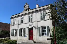
 The town hall in Pargny-sous-Mureau | |
 Coat of arms | |
Location of Pargny-sous-Mureau | |
 Pargny-sous-Mureau  Pargny-sous-Mureau | |
| Coordinates: 48°22′05″N 5°36′20″E / 48.3681°N 5.6056°E | |
| Country | France |
| Region | Grand Est |
| Department | Vosges |
| Arrondissement | Neufchâteau |
| Canton | Neufchâteau |
| Intercommunality | CC l'Ouest Vosgien |
| Government | |
| • Mayor (2020–2026) | Hervé Bidal[1] |
| Area 1 | 17.97 km2 (6.94 sq mi) |
| Population | 179 |
| • Density | 10.0/km2 (26/sq mi) |
| Time zone | UTC+01:00 (CET) |
| • Summer (DST) | UTC+02:00 (CEST) |
| INSEE/Postal code | 88344 /88350 |
| Elevation | 288–443 m (945–1,453 ft) (avg. 300 m or 980 ft) |
| 1 French Land Register data, which excludes lakes, ponds, glaciers > 1 km2 (0.386 sq mi or 247 acres) and river estuaries. | |
Pargny-sous-Mureau (French pronunciation: [paʁɲi su myʁo] ⓘ) is a commune in the Vosges department in Grand Est in northeastern France.
Geography
The commune occupies the valley of the little River Saônelle, being positioned between Liffol-le-Grand et Coussey, near the western edge of the département.
The abbey
The Premonstratensian Abbey was demolished in 1790, though a few pieces of walls and a porch survive, albeit in an increasingly bad condition.
A stream crosses the grounds of the former abbey, its water still channeled for a section, within a man-made tunnel.
See also
References
- ↑ "Répertoire national des élus: les maires". data.gouv.fr, Plateforme ouverte des données publiques françaises (in French). 9 August 2021.
- ↑ "Populations légales 2021". The National Institute of Statistics and Economic Studies. 28 December 2023.
Wikimedia Commons has media related to Pargny-sous-Mureau.
This article is issued from Wikipedia. The text is licensed under Creative Commons - Attribution - Sharealike. Additional terms may apply for the media files.