North Minahasa Regency
Kabupaten Minahasa Utara | |
|---|---|
 Seal | |
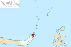 Location in North Sulawesi | |
 North Minahasa Regency Location in Indonesia | |
| Coordinates: 1°24′9″N 124°57′36″E / 1.40250°N 124.96000°E | |
| Country | Indonesia |
| Province | North Sulawesi |
| Established | 20 November 2003 |
| Capital | Airmadidi |
| Government | |
| • Regent | Joune Ganda |
| • Vice Regent | Kevin William Lotulung |
| Area | |
| • Total | 1,059.24 km2 (408.97 sq mi) |
| Population (mid 2022 estimate)[1] | |
| • Total | 229,368 |
| • Density | 220/km2 (560/sq mi) |
| Time zone | UTC+8 (WITA) |
| Website | minutkab.go.id |
North Minahasa Regency is a regency in North Sulawesi, Indonesia. Its capital is Airmadidi. It was originally part of the Minahasa Regency until it was split off and established as a separate regency on 20 November 2003.[2] It covers an area of 1,059.24 km2, and had a population of 188,904 at the 2010 Census;[3] this had risen to 224,993 at the 2020 Census,[4] and the official estimate as at mid 2022 was 229,368.[1] The Regency includes the offshore islands of Bangka (Pulau Bangka) and Talisei (Pulau Talise) to the north of Sulawesi, and Mantenang (Pulau Mantehage) and Naeng Besar (Pulau Nain Besar) to the northwest.
Administration
The regency is divided into ten districts (kecamatan), tabulated below with their areas and their populations from the 2010 Census[3] and the 2020 Census,[4] together with the official estimates as at mid 2022.[1] The table also includes the locations of the administrative centres and the number of administrative villages in each district (totaling 125 rural desa and 6 urban kelurahan - the latter all in Airmadidi District), and its postal codes.
| Kode Wilayah | Name of District (kecamatan) | Area in km2 | Pop'n Census 2010 | Pop'n Census 2020 | Pop'n Estimate mid 2022 | Admin centre | No. of villages | Post codes |
|---|---|---|---|---|---|---|---|---|
| 71.06.01 | Kema (a) | 78.76 | 15,009 | 17,774 | 18,095 | Kema Satu | 10 | 95379 |
| 71.06.02 | Kauditan | 108.20 | 23,620 | 28,643 | 29,297 | Kauditan Satu | 12 | 95372 |
| 71.06.03 | Airmadidi | 86.66 | 26,558 | 30,981 | 31,446 | Airmadidi Atas | 9 (b) | 95371 |
| 71.06.08 | Kalawat | 39.03 | 26,675 | 32,784 | 33,623 | Kolongan | 12 | 95378 |
| 71.06.05 | Dimembe | 166.43 | 22,774 | 27,553 | 28,169 | Dimembe | 11 | 95373 |
| 71.06.09 | Talawaan | 82.51 | 17,678 | 22,360 | 23,063 | Talawaan | 12 | 95370 |
| 71.06.04 | Wori (c) | 90.70 | 17,980 | 20,749 | 21,015 | Wori | 20 | 95376 |
| 71.06.06 | Likupang Barat (d) (West Likupang) | 104.29 | 16,988 | 18,015 | 17,943 | Serey | 20 | 95377 |
| 71.06.10 | Likupang Selatan (South Likupang) | 11.82 | 5,103 | 5,794 | 5,849 | Kokoleh Satu | 7 | 95374 |
| 71.06.07 | Likupang Timur (e) (East Likupang) | 290.84 | 16,519 | 20,340 | 20,868 | Likupang Satu | 18 | 95375 |
| Totals | 1,059.24 | 188,904 | 224,993 | 229,368 | Airmadidi | 131 |
Notes: (a) including 10 small offshore islands. (b) comprises 6 kelurahan (Airmadidi Atas, Airmadidi Bawah, Rap-Rap, Sarongsong Dua, Sarongsong Satu and Sukur) and 3 desa.
(c) including offshore islands of Mantehage, Nain Besar, Nain Kecil, Bulu, Makelehi and Paniki to the west.
(d) including offshore islands of Talisei, Kelapa Dua and 10 smaller to the north. (e) including offshore islands of Bangka and 18 smaller to the north.
References
1°24′09″N 124°57′36″E / 1.40250°N 124.96000°E