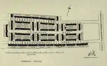
Plan of the Norbury Estate from the Report of the Housing for the Working Classes Committee, London County Council, 1912–1913
The Norbury Estate originated as a London County Council cottage estate constructed between 1901 and 1920 at Norbury in what is now the north of the London Borough of Croydon. It was declared a conservation area in 2008.
The site was a former brickfield, and the clay recovered was fired to make bricks for this estate and Totterdown Fields.
The estate was influenced by Ebenezer Howard's Garden city movement and the Arts and Crafts movement, with high quality external detailing and an open setting with privet hedges, front gardens and wide grass verges.[1]
Design
| Estate name | Area | No of dwellings | Population 1938 | Population density |
|---|---|---|---|---|
| Pre-1914 | ||||
| Norbury | 11 | 218 | 867 | 19.8 per acre (49/ha) |
| Old Oak | 32 | 736 | 3519 | 23 per acre (57/ha) |
| Totterdown Fields | 39 | 1262 | — | 32.4 per acre (80/ha) |
| Tower Gardens White Hart Lane | 98 | 783 | 5936 | 8 per acre (20/ha) |
| 1919–1923 | ||||
| Becontree | 2770 | 25769[lower-alpha 1] | 115652 | 9.3 per acre (23/ha) |
| Bellingham | 252 | 2673 | 12004 | 10.6 per acre (26/ha) |
| Castelnau | 51 | 644 | 2851 | 12.6 per acre (31/ha) |
| Dover House Estate Roehampton Estate | 147 | 1212 | 5383 | 8.2 per acre (20/ha) |
| 1924–1933 | ||||
| Downham | 600 | 7096 | 30032 | 11.8 per acre (29/ha) |
| Mottingham | 202 | 2337 | 9009 | 11.6 per acre (29/ha) |
| St Helier | 825 | 9068 | 39877 | 11 per acre (27/ha) |
| Watling | 386 | 4034 | 19110 | 10.5 per acre (26/ha) |
| Wormholt | 68 | 783 | 4078 | 11.5 per acre (28/ha) |
| 1934–1939 | ||||
| Chingford[lower-alpha 2] | 217 | 1540 | — | 7.1 per acre (18/ha) |
| Hanwell (Ealing) | 140 | 1587 | 6732 | 11.3 per acre (28/ha) |
| Headstone Lane | 142 | n.a | 5000 | |
| Kenmore Park | 58 | 654 | 2078 | 11.3 per acre (28/ha) |
| Thornhill (Royal Borough of Greenwich) | 21 | 380 | 1598 | 18.1 per acre (45/ha) |
| Whitefoot Lane (Downham) | 49 | n.a | n.a. | |
|
Source:
| ||||
Location
The estate is in the London Borough of Croydon, just west of the A23 and south of Norbury Station. It is bounded by Palmers Road, Darcy Road, Northborough Road and Tylecroft Road.[2]
See also
References
- Notes
- ↑ Appraisal 2013.
- ↑ Appraisal 2013, pp. 2, 3.
- Bibliography
- "Norbury Estate Conservation Area Appraisal and Management Plan" (PDF). London Borough of Croydon. 2013. Archived from the original (PDF) on 27 October 2017. Retrieved 13 August 2021.
External links
This article is issued from Wikipedia. The text is licensed under Creative Commons - Attribution - Sharealike. Additional terms may apply for the media files.