| Nissequogue River | |
|---|---|
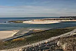
 Mouth on Long Island Sound | |
  | |
| Location | |
| Country | United States |
| State | New York |
| Region | Suffolk |
| District | Smithtown |
| Physical characteristics | |
| Source | Caleb Smith Park (at northern end of New Mill Pond) |
| • coordinates | 40°50′34″N 73°13′40″W / 40.8428°N 73.2279°W |
| • elevation | 29 ft (8.8 m) |
| Mouth | Nissequogue River State Park at Long Island Sound |
• coordinates | 40°54′15″N 73°13′48″W / 40.90426°N 73.23011°W |
• elevation | 0 ft (0 m) |
| Length | 8.3 mi (13.4 km), SN |
| Discharge | |
| • average | 42.2 cu ft/s (1.19 m3/s) |
The Nissequogue River is an 8.3-mile (13.4 km) long river flowing from Smithtown, New York into the Long Island Sound. Its average discharge of 42.2 cubic feet per second (1.19 m3/s)[1] is the most of any of the freshwater rivers on Long Island. The river, like all other freshwater rivers on the island, is totally derived from groundwater (not from lakes). Its name is derived from one of the Algonquian-speaking Nissequaq tribe in the area.[2]
The river rises south of NY-454 just east of the Hauppauge County Offices and flows into Blydenburgh Park Pond where other tributaries that come from East Hauppauge and Commack meet and are dammed at Blydenburgh Pond. The river continues in a northeasterly direction, picking up additional tributaries from the north in Caleb Smith Park in Smithtown (where special regulation trout fishing is available). It is dammed once more before becoming an estuary at NY-25 where it then flows to Kings Park, New York, entering Long Island Sound at Nissequogue River State Park. Since much of the river is an estuary canoeists travel in both directions based on the tides.
Fish found in the river include Striped Bass, Bluefish, Summer Flounder, Winter Flounder, Porgies, Eels, Brown, Rainbow and Brook Trout, Yellow Perch, Largemouth Bass, Alewives, Herring, Shad, etc.
List of crossings of the Nissequogue River
| Crossings | Carries | Location | Coordinates |
|---|---|---|---|
| Unnamed road bridge | Landing Avenue | Smithtown | |
| Unnamed road bridge | ' | ||
| Old Main Street Bridge | Pedestrian Bridge | ||
| Unnamed railroad bridge | Long Island Rail Road Port Jefferson Branch Trestle | ||
| Unnamed road bridge | Mill Dam Road (Private) | Blydenberg County Park | |
| Unnamed road bridge | New Mill Road (Long Island Greenbelt Trail) | ||
| Confluence with Northeast Branch at Mill Dam Pond | |||
| Unnamed Road Bridge | Blydenberg County Park Driveway | ||
| Unnamed road bridge | Hauppauge | ||
| Unnamed road Bridge | Raoul Wallenberg Drive (County Access Road) |
||
Northeast Branch
| Crossings | Carries | Location | Coordinates |
|---|---|---|---|
| Unnamed road bridge | Brooksite Drive | Smithtown | |
| Unnamed road bridge | ' | ||
| Unnamed road bridge | Village of The Branch | ||
| Unnamed road bridge | Terrace Lane | ||
| Unnamed road bridge | Branch Drive | ||
| Unnamed road bridge | Hauppauge | ||
| Unnamed road bridge | Bow Drive (Closed to motor vehicles) |
||
| Unnamed road Bridge | |||
References
- ↑ "Canoe Trip of the Nissequogue River - eserc.stonybrook.edu". Archived from the original on 2011-07-18. Retrieved 2007-11-24.
- ↑ Suffolk County Pre-History to 1683 - rootsweb.com