Nicholson Road | |
|---|---|
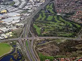 | |
| Intersection of Roe Highway at Nicholson Road | |
| General information | |
| Type | Road |
| Length | 24 km (15 mi) |
| Opened | 1960s |
| Route number(s) | |
| Major junctions | |
| North end | |
| |
| South end | |
| Location(s) | |
| Major suburbs | Lynwood, Thornlie, Canning Vale |
Nicholson Road is a major north–south road in the southeastern suburbs of Perth, Western Australia, connecting Albany Highway in Cannington with the large residential areas of Thornlie and Canning Vale, before leaving the Perth urban area and terminating in Oakford.
Nicholson Road is allocated State Route 31.[1]
History
Until the construction of Kwinana Freeway to Thomas Road in 1993, Nicholson Road was one of southern Perth's most important routes.
Nicholson Road formerly crossed the Kwinana freight railway at a level crossing. Construction of a six-lane road bridge over the rail line to replace the crossing began in May 2017 and was completed in March 2018.[2]
Major intersections
All intersections below are at-grade except for the intersections with Roe Highway and Armadale Road, which are grade-separated interchanges in favour of those two roads over Nicholson Road.
| LGA | Location | km | mi | Destinations | Notes |
|---|---|---|---|---|---|
| Gosnells | Beckenham | 0.0 | 0.0 | Traffic light intersection with bus priority slip lanes | |
| Canning River | 0.5 | 0.31 | Nicholson Road Bridge | ||
| Canning–Gosnells boundary | Ferndale–Langford boundary | 0.8 | 0.50 | Traffic light intersection | |
| Langford–Lynwood–Parkwood tripoint | 1.0 | 0.62 | Metcalfe Road – Parkwood | Unsignalised intersection | |
| Langford–Parkwood–Lynwood tripoint | 2.9 | 1.8 | Roundabout | ||
| Lynwood–Langford–Thornlie–Canning Vale quadripoint | 3.5 | 2.2 | Signalised diamond interchange favouring Roe Highway | ||
| Thornlie–Canning Vale boundary | 4.0 | 2.5 | Wilfred Road east / Bannister Road west | Signalised intersection | |
| 4.6 | 2.9 | Yale Road east / Garden Street south – Kenwick, Huntingdale | Roundabout. Nicholson Road traffic need to use the third exit if going southbound. Slip roads are available for Nicholson Road northbound and turning from Nicholson-south onto Yale Road | ||
| Canning Vale | 5.2 | 3.2 | Panama Street | Unsignalised intersection, access to future Nicholson Road railway station | |
| 6.2 | 3.9 | Amherst Road | Signalised intersection | ||
| 8.3 | 5.2 | Signalised intersection | |||
| Canning–Gosnells–Armadale–Cockburn quadripoint | Canning Vale–Harrisdale–Piara Waters–Treeby quadripoint | 11.3 | 7.0 | Warton Road – Jandakot, Huntingdale, Southern River | Roundabout |
| Armadale | Harrisdale–Piara Waters boundary | 12.4 | 7.7 | Wright Road – Forrestdale, Southern River | Roundabout |
| 12.8 | 8.0 | Easthope Link east / Broadway Boulevard west | Roundabout | ||
| 13.1 | 8.1 | Yellowwood Avenue | Signalised intersection | ||
| 12.8 | 8.0 | Exchange Avenue east / Mason Road west – Treeby, Jandakot | Roundabout | ||
| Forrestdale–Piara Waters boundary | 14.2 | 8.8 | Riva Entrance east / Piara Drive west | Roundabout | |
| 15.0 | 9.3 | Greywacke Entrance west | Roundabout | ||
| 15.4 | 9.6 | Roundabout interchange favouring Armadale Road. Overpass known as the Hugo Throssell VC Bridge | |||
| Armadale–Serpentine–Jarrahdale boundary | Forrestdale–Oakford boundary | 19.0 | 11.8 | Rowley Road – Banjup, Hilbert, Darling Downs, Hammond Park | Unsignalised, staggered T-intersections favouring Nicholson Road |
| Serpentine–Jarrahdale | Oakford | 21.7 | 13.5 | Unsignalised, staggered T-intersections favouring Thomas Road. State Route 31 southern terminus. Note the road southbound reduces in quality to a one lane seal. | |
| 23.8 | 14.8 | Abernethy Road – Byford | Nicholson Road ends at a sharp eastbound curve to become Abernethy Road | ||
| |||||
See also
References
- ↑ Distance book (12 ed.). Main Roads Western Australia. 2012. pp. 4–5. ISBN 0 7309 7657 2. Archived from the original on 24 October 2012. Retrieved 28 December 2013.
- ↑ "Nicholson Road Bridge Over Rail Project". RECO. Retrieved 26 July 2022.
External links
![]() Media related to Nicholson Road at Wikimedia Commons
Media related to Nicholson Road at Wikimedia Commons
| National Highways | |||
|---|---|---|---|
| National Routes | |||
| State Routes | |||
| Tourist Drives | |||