Neunkirchen | |
|---|---|
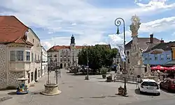 main square of Neunkirchen | |
 Flag  Coat of arms | |
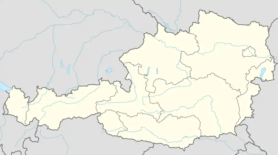 Neunkirchen Location within Austria | |
| Coordinates: 47°44′N 16°5′E / 47.733°N 16.083°E | |
| Country | Austria |
| State | Lower Austria |
| District | Neunkirchen |
| Government | |
| • Mayor | Herbert Osterbauer (ÖVP) |
| Area | |
| • Total | 20.3 km2 (7.8 sq mi) |
| Elevation | 371 m (1,217 ft) |
| Population (2018-01-01)[2] | |
| • Total | 12,879 |
| • Density | 630/km2 (1,600/sq mi) |
| Time zone | UTC+1 (CET) |
| • Summer (DST) | UTC+2 (CEST) |
| Postal code | 2620 |
| Area code | 02635 |
| Website | www.neunkirchen.gv.at |
Neunkirchen (German: [ˈnɔʏnˌkɪʁçn̩] ⓘ) is the capital of the district of Neunkirchen in the Austrian state of Lower Austria. As of 2020 it has a population of 12,721.
Geography
Neunkirchen is situated in the Steinfeld region of the Vienna Basin, part of Industrieviertel in the southwestern area of Lower Austria. Schwarza river is flowing through it.
Geographic breakdown
The municipality consists of three localities, which are also cadastral communities of the same names (area as of 1 January 2001,[3] population as of 1 January 2022[4]):
- Mollram (8.23 km²; pop. 702)
- Neunkirchen (5.96 km²; pop. 11.152) Quarters: Innere Stadt, Tal, Steinplatte, Mühlfeld, Au, Steinfeld, Lerchenfeld, Blätterstraßensiedlung
- Peisching (6.12 km²; pop. 691)
Neighbouring municipalities
NE: Sankt Egyden am Steinfeld; E: Breitenau; SE: Natschbach-Loipersbach; S: Wartmannstetten; W: Ternitz; NW: Würflach
History
Neunkirchen is one of the oldest settlements in the Vienna Basin. It has been permanently settled since the La Tène culture. There was a Roman settlement from about 30 to 400 AD near the inner city, but its name is unknown. Neunkirchen was first mentioned in 1094 as "Niuwenchirgun". The town was given city status in 1920.
Population
| Year | Pop. | ±% |
|---|---|---|
| 1869 | 6,540 | — |
| 1880 | 7,677 | +17.4% |
| 1890 | 9,658 | +25.8% |
| 1900 | 11,797 | +22.1% |
| 1910 | 12,920 | +9.5% |
| 1923 | 12,920 | +0.0% |
| 1934 | 12,563 | −2.8% |
| 1939 | 11,894 | −5.3% |
| 1951 | 11,615 | −2.3% |
| 1961 | 10,924 | −5.9% |
| 1971 | 10,875 | −0.4% |
| 1981 | 11,005 | +1.2% |
| 1991 | 10,784 | −2.0% |
| 2001 | 11,028 | +2.3% |
| 2011 | 12,323 | +11.7% |
Personalities
- Anton Burger, Austrian-German commandant of Theresienstadt concentration camp, Nazi SS war criminal, born in Neunkirchen.
- Christian Fuchs, Austrian footballer, born in Neunkirchen.
- Markus Höttinger, Austrian racing driver, born in Neunkirchen.
- Hubert Mara, Austrian computer scientist, born in Neunkirchen.
- Julius Steinfeld, Agudat Yisrael politician, coorganizer of the Kindertransport.
- Alfons Maria Stickler, Austrian prelate, born in Neunkirchen.
References
- ↑ "Dauersiedlungsraum der Gemeinden Politischen Bezirke und Bundesländer - Gebietsstand 1.1.2018". Statistics Austria. Retrieved 10 March 2019.
- ↑ "Einwohnerzahl 1.1.2018 nach Gemeinden mit Status, Gebietsstand 1.1.2018". Statistics Austria. Retrieved 9 March 2019.
- ↑ "Ortsverzeichnis 2001 Niederösterreich" [Directory of Localities in Lower Austria 2001] (PDF) (in Austrian German). Vienna, Austria: Statistik Austria. p. 259. Retrieved 23 February 2023.
- ↑ "Bevölkerung am 1.1.2022 nach Ortschaften (Gebietsstand 1.1.2022)" [Population as of 1 January 2022 (Area as of 1 January 2022] (ODS) (in Austrian German). Vienna: Statistik Austria. Retrieved 2023-02-23.