Nduga Regency
Kabupaten Nduga | |
|---|---|
 Seal | |
| Motto: Nindi Misiget Pem Jambu Wanuok O | |
 Location in Highland Papua | |
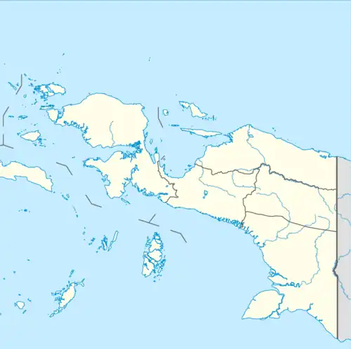 Nduga Regency Location in Indonesian Papua 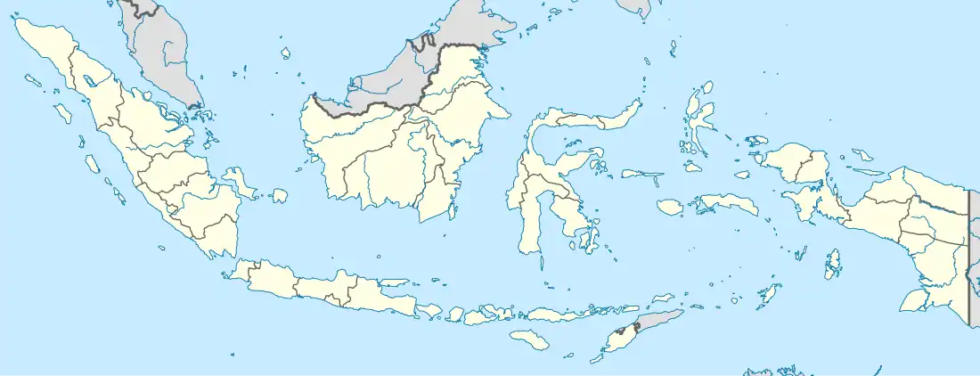 Nduga Regency Location in Indonesia | |
| Coordinates: 4°27′03″S 138°06′03″E / 4.4509°S 138.1009°E | |
| Country | |
| Province | Highland Papua |
| Capital | Kenyam |
| Government | |
| • Regent | Yairus Gwijangge |
| • Vice Regent | Wentius Nimiangge |
| Area | |
| • Total | 12,941 km2 (4,997 sq mi) |
| Population (mid 2022 estimate)[1] | |
| • Total | 109,630 |
| • Density | 8.5/km2 (22/sq mi) |
| Time zone | UTC+9 (Indonesia Eastern Time) |
| Area code | (+62) 967 |
| Website | www |
Nduga Regency is one of the regencies (kabupaten) in the Indonesian province of Highland Papua. Nduga Regency was created on 4 January 2008 by separation from Jayawijaya Regency in accordance with Law No. 6/2008. It covers an area of 12,941 km2, and had a population of 79,053 at the 2010 Census[2] and 106,533 at the 2020 Census;[3] the official estimate as at mid 2022 was 109,630 - comprising 59,587 males and 50,043 females.[1] The administrative centre is at the town of Kenyam.
Administrative Districts
In 2010 the Nduga Regency comprised eight districts (distrik), listed below with their areas and populations at the 2010 Census.[2]
| Name of District (distrik) | Area in km2 | Pop'n 2010 Census |
|---|---|---|
| Wosak | 1,893 | 8,571 |
| Kenyam | 1,773 | 8,148 |
| Geselma | 2,903 | 8,098 |
| Mapenduma | 2,202 | 6,342 |
| Mugi | 684 | 9,266 |
| Yigi | 782 | 16,493 |
| Mbuwa | 937 | 11,234 |
| Gearek | 1,768 | 10,901 |
Since 2010, the number of districts has been raised to thirty-two by the splitting of existing districts. The revised 32 districts are tabulated below with their areas and their populations at the 2020 Census,[3] together with the official estimates as at mid 2022.[1] The table also includes the locations of the district administrative centres, the number of administrative villages (kampung) in each district, and its post code.
| Kode Wilayah | Name of District (distrik) | Area in km2 | Pop'n 2020 Census | Pop'n mid 2022 estimate | Admin centre | No. of villages | Post code |
|---|---|---|---|---|---|---|---|
| 95.08.04 | Wosak | 196 | 3,329 | 3,227 | Pilini | 5 | 99929 |
| 95.08.28 | Moba | 274 | 2,642 | 2,561 | Moba | 8 | 99926 |
| 95.08.27 | Pija | 153 | 1,520 | 1,473 | Pija | 5 | 99928 |
| 95.08.25 | Kora | 651 | 1,786 | 1,731 | Kora | 5 | 99923 |
| 95.08.01 | Kenyam | 223 | 5,946 | 6,394 | Kenyam | 9 | 99922 |
| 95.08.23 | Mbua Tengah (Central Mbua) | 323 | 3,556 | 3,824 | Paris | 9 | 99925 |
| 95.08.31 | Krepkuri | 1,518 | 2,714 | 2,918 | Krepkuri | 6 | 99924 |
| 95.08.24 | Embetpem | 334 | 2,858 | 3,073 | Embetpem | 5 | 99920 |
| 95.08.05 | Geselma | 220 | 4,220 | 4,521 | Geselma | 3 | 99903 |
| 95.08.14 | Kilmid | 377 | 2,617 | 2,804 | Kilmid | 4 | 99907 |
| 95.08.13 | Yenggelo | 432 | 2,111 | 2,262 | Yenggelo | 4 | 99918 |
| 95.08.15 | Alama | 3,797 | 1,816 | 1,945 | Alama | 4 | 99901 |
| 95.08.12 | Meborok | 394 | 3,933 | 4,213 | Merorok | 14 | 99912 |
| 95.08.02 | Mapenduma | 55 | 3,154 | 3,428 | Mapenduma | 10 | 99909 |
| 95.08.09 | Koroptak | 168 | 2,552 | 2,774 | Kroptak | 6 | 99908 |
| 95.08.11 | Paro | 868 | 2,751 | 2,991 | Paro | 5 | 99916 |
| 95.08.10 | Kegayem | 86 | 3,941 | 4,283 | Kegayem | 13 | 99906 |
| 95.08.06 | Mugi | 92 | 4,384 | 4,536 | Mugi | 18 | 99913 |
| 95.08.16 | Yal | 48 | 5,378 | 5,565 | Yal | 20 | 99942 |
| 95.08.17 | Mam | 106 | 4,291 | 4,440 | Mam | 14 | 99941 |
| 95.08.03 | Yigi | 87 | 4,568 | 4,361 | Yigi | 12 | 99919 |
| 95.08.18 | Dal | 88 | 3,538 | 3,377 | Dal | 6 | 99902 |
| 95.08.19 | Nirkuri | 189 | 3,645 | 3,479 | Nirkuri | 10 | 99915 |
| 95.08.20 | Inikgal | 51 | 3,848 | 3,673 | Biripem | 8 | 99904 |
| 95.08.07 | Mbuwa | 470 | 4,630 | 4,816 | Mbuwa | 6 | 99910 |
| 95.08.21 | Iniye | 301 | 4,611 | 4,796 | Iniye | 6 | 99905 |
| 95.08.29 | Wutpaga | 236 | 2,230 | 2,320 | Wutpaga | 6 | 99917 |
| 95.08.30 | Nenggeangin | 109 | 2,216 | 2,305 | Nenggeangin | 5 | 99914 |
| 95.08.22 | Mbulmu Yalma | 190 | 3,818 | 3,971 | Uburu | 7 | 99911 |
| 95.08.08 | Gearek | 200 | 4,259 | 4,066 | Gearek | 7 | 99921 |
| 95.08.32 | Pasir Putih | 437 | 1,720 | 1,642 | Pasir Putih | 4 | 99927 |
| 95.08.26 | Wusi | 268 | 1,950 | 1,861 | Wusi | 4 | 99930 |
| Totals | 12,941 | 106,533 | 109,630 | Kenyam | 248 |
References
External links
Regencies and cities of Highland Papua | ||
|---|---|---|
Capital: Wamena | ||
| Regencies |  | |