
Location of Yellowstone County in Montana
This is a list of the National Register of Historic Places listings in Yellowstone County, Montana. It is intended to be a complete list of the properties and districts on the National Register of Historic Places in Yellowstone County, Montana, United States. The locations of National Register properties and districts for which the latitude and longitude coordinates are included below, may be seen in a map.[1]
There are 45 properties and districts listed on the National Register in the county, including 2 National Historic Landmarks.
This National Park Service list is complete through NPS recent listings posted January 12, 2024.[2]
Listings county-wide
| [3] | Name on the Register | Image | Date listed[4] | Location | City or town | Description |
|---|---|---|---|---|---|---|
| 1 | Acme Building | 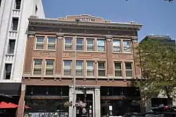 Acme Building |
November 9, 2005 (#05001279) |
109-111 N. Broadway 45°46′59″N 108°30′14″W / 45.7831°N 108.5039°W |
Billings | |
| 2 | Antelope Stage Station | January 19, 1983 (#83001078) |
East of Broadview 46°02′38″N 108°43′53″W / 46.0439°N 108.7314°W |
Broadview | ||
| 3 | Armour Cold Storage | 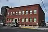 Armour Cold Storage |
July 7, 2004 (#04000670) |
1 S. Broadway 45°46′50″N 108°30′12″W / 45.7806°N 108.5033°W |
Billings | |
| 4 | Babcock Theater | 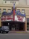 Babcock Theater |
April 9, 2013 (#13000153) |
114-124 N. 28th & 2808-2812 2nd Aves. 45°46′58″N 108°30′26″W / 45.7827°N 108.5072°W |
Billings | |
| 5 | James F. Battin Federal Building (Courthouse & Federal Office Building) |  James F. Battin Federal Building (Courthouse & Federal Office Building) |
January 13, 2023 (#100008535) |
316 North 26th St. 45°47′07″N 108°30′20″W / 45.7853°N 108.5055°W |
Billings | |
| 6 | Billings Chamber of Commerce Building | 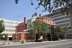 Billings Chamber of Commerce Building |
January 20, 1972 (#72000739) |
303 N. 27th St. 45°47′05″N 108°30′19″W / 45.7847°N 108.5053°W |
Billings | |
| 7 | Billings Communal Mausoleum | June 28, 2021 (#100006704) |
1704 Central Ave. 45°46′04″N 108°33′40″W / 45.7679°N 108.5612°W |
Billings | ||
| 8 | Billings Historic District | _-_Yellowstone_County%252C_Montana_2.png.webp) Billings Historic District |
March 13, 1979 (#79001427) |
Roughly bounded by N. 23rd and N. 25th Sts. and 1st and Montana Aves.; also 2600 (2528), 2604-2606, 2608, 2610-2614, and 2624 Montana Ave. 45°47′02″N 108°29′59″W / 45.7839°N 108.4997°W |
Billings | Billings Townsite Historic District (aka Billings Historic District?) was created in 1979, expanded on April 20, 2006[5][6][7] |
| 9 | Billings Old Town Historic District | 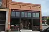 Billings Old Town Historic District |
September 16, 2010 (#10000753) |
Generally bounded by Montana Ave. on the north; S. 26th on the east; 1st Ave., S on the south; and S. 30th St. on the west 45°46′50″N 108°30′15″W / 45.7806°N 108.5042°W |
Billings | May not be an NRHP new listing, listing code "DR" which means "DATE RECEIVED/PENDING NOMINATION". Try reference:[8][9] |
| 10 | Billings West Side School | 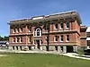 Billings West Side School |
March 20, 2002 (#02000214) |
415 Broadwater Ave. 45°46′40″N 108°31′32″W / 45.7778°N 108.5256°W |
Billings | |
| 11 | Black Otter Trail | 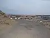 Black Otter Trail |
January 5, 2007 (#06001224) |
Black Otter Trail 45°48′02″N 108°29′49″W / 45.8006°N 108.4969°W |
Billings | |
| 12 | Boothill Cemetery | 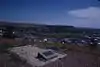 Boothill Cemetery |
April 17, 1979 (#79001428) |
North of Billings 45°48′09″N 108°28′48″W / 45.8025°N 108.48°W |
Billings | |
| 13 | Dude Rancher Lodge | 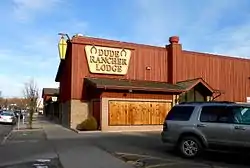 Dude Rancher Lodge |
July 22, 2010 (#10000489) |
415 N. 29th St. 45°47′05″N 108°30′35″W / 45.7847°N 108.5097°W |
Billings | |
| 14 | Electric Building | _-_Yellowstone_County%252C_Montana.png.webp) Electric Building |
March 1, 2002 (#02000105) |
113-115 Broadway 45°47′04″N 108°30′22″W / 45.7844°N 108.5061°W |
Billings | |
| 15 | Abraham and Carrie Erb House | 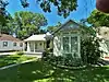 Abraham and Carrie Erb House |
June 9, 2005 (#05000564) |
110 4th Ave. 45°40′12″N 108°46′32″W / 45.67°N 108.7756°W |
Laurel | |
| 16 | Fire House No. 2 | 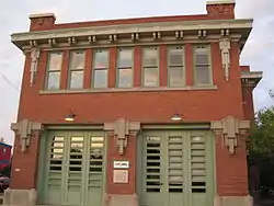 Fire House No. 2 |
February 29, 1980 (#80002436) |
201 E. 30th St. 45°46′39″N 108°30′12″W / 45.7775°N 108.5033°W |
Billings | |
| 17 | Fratt-Link House | 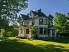 Fratt-Link House |
November 9, 2020 (#100005777) |
142 Clark Ave. 45°46′48″N 108°31′12″W / 45.7801°N 108.5201°W |
Billings | |
| 18 | Kate Fratt Memorial Parochial School | 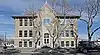 Kate Fratt Memorial Parochial School |
July 28, 2020 (#100005389) |
205 North 32nd St. 45°46′52″N 108°30′43″W / 45.7811°N 108.5119°W |
Billings | |
| 19 | Garfield School | 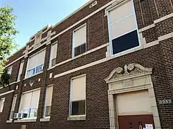 Garfield School |
October 3, 2012 (#12000830) |
3212 1st Ave., S 45°46′35″N 108°30′30″W / 45.7765°N 108.5082°W |
Billings | |
| 20 | Arnold Graf House | 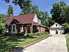 Arnold Graf House |
April 20, 2015 (#15000160) |
633 Highland Park Dr. 45°47′49″N 108°31′57″W / 45.797°N 108.5326°W |
Billings | |
| 21 | Hoskins Basin Archeological District | November 20, 1974 (#74001100) |
Address restricted[10] |
Billings | ||
| 22 | Huntley Bridge |  Huntley Bridge |
March 26, 2012 (#12000175) |
Mile 12, MT 312, over the Yellowstone River 45°54′14″N 108°19′04″W / 45.9040°N 108.3177°W |
Huntley | |
| 23 | Huntley Project Office | 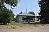 Huntley Project Office |
June 5, 2017 (#100001033) |
2291 2nd St., W. 45°57′00″N 108°08′42″W / 45.9501°N 108.1449°W |
Ballantine | |
| 24 | L and L Building | 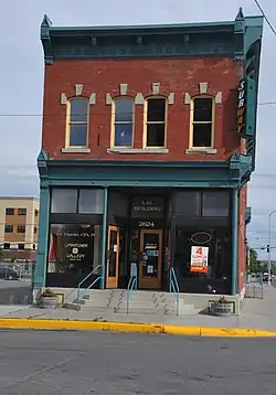 L and L Building |
October 1, 1979 (#08001227) |
2624 Minnesota Ave. 45°46′53″N 108°30′07″W / 45.7815°N 108.5019°W |
Billings | |
| 25 | Laurel Downtown Historic District | 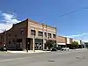 Laurel Downtown Historic District |
September 16, 2010 (#10000768) |
Roughly bounded by the Burlington Northern Santa Fe Railway Company tracks to the south, Third St., S. to the north, Wyoming Ave. 45°40′11″N 108°46′12″W / 45.6697°N 108.77°W |
Laurel | |
| 26 | Masonic Temple | _-_Yellowstone_County%252C_Montana.png.webp) Masonic Temple |
April 17, 1986 (#86000847) |
2806 3rd Ave., N. 45°47′01″N 108°30′25″W / 45.7836°N 108.5069°W |
Billings | |
| 27 | McKinley Elementary School | March 16, 2021 (#100006311) |
820 North 31st St. 45°47′12″N 108°30′57″W / 45.7866°N 108.5159°W |
Billings | ||
| 28 | McMullen Hall | 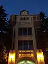 McMullen Hall |
September 8, 2015 (#15000574) |
1500 University Dr. 45°47′48″N 108°31′19″W / 45.7966°N 108.5220°W |
Billings | |
| 29 | Montana National Bank | March 14, 2022 (#100007494) |
201 North Broadway 45°46′59″N 108°30′24″W / 45.7831°N 108.5067°W |
Billings | ||
| 30 | Preston B. Moss House | 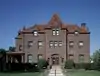 Preston B. Moss House |
April 30, 1982 (#82003181) |
914 Division St.[11] 45°46′46″N 108°30′55″W / 45.7794°N 108.5153°W |
Billings | |
| 31 | Mossman Overpass | 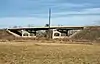 Mossman Overpass |
March 26, 2012 (#12000174) |
Mile 57 on an Interstate 90 frontage road 45°40′57″N 108°42′50″W / 45.6826°N 108.7139°W |
Laurel | Over railroad tracks. |
| 32 | Austin North House | 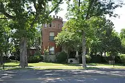 Austin North House |
November 23, 1977 (#77000822) |
622 N. 29th St. 45°47′11″N 108°30′41″W / 45.7864°N 108.5114°W |
Billings | |
| 33 | North Elevation Historic District |  North Elevation Historic District |
November 29, 2016 (#16000807) |
Bounded by 12th Ave. N, alley between N 31st & 30th Sts., 9th Ave. N & 32ns St. N 45°47′23″N 108°31′08″W / 45.7897°N 108.5190°W |
Billings | |
| 34 | Northern Hotel | 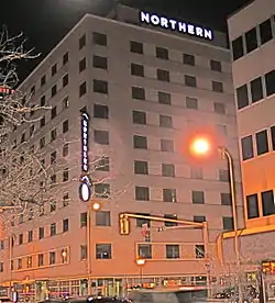 Northern Hotel |
June 12, 2013 (#13000369) |
19 N. Broadway 45°46′55″N 108°30′20″W / 45.7820°N 108.5055°W |
Billings | |
| 35 | I.D. O'Donnell House | 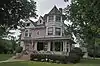 I.D. O'Donnell House |
November 23, 1977 (#77000823) |
105 Clark Ave. 45°46′49″N 108°31′02″W / 45.7803°N 108.5172°W |
Billings | |
| 36 | Oliver Building | 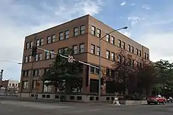 Oliver Building |
October 1, 1979 (#08001228) |
2702 Montana Ave. 45°46′54″N 108°30′14″W / 45.7818°N 108.5038°W |
Billings | |
| 37 | Parmly Billings Memorial Library | 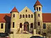 Parmly Billings Memorial Library |
October 26, 1972 (#72000740) |
2822 Montana Ave. 45°46′50″N 108°30′21″W / 45.7806°N 108.5057°W |
Billings | |
| 38 | Pictograph Cave | 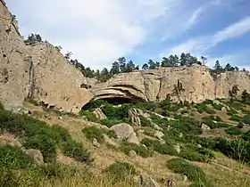 Pictograph Cave |
October 15, 1966 (#66000439) |
7 miles (11 km) southeast of Billings in Indian Caves Park 45°44′12″N 108°25′56″W / 45.7367°N 108.4322°W |
Billings | |
| 39 | Pioneer Park | April 13, 2021 (#100006391) |
Roughly bounded by Parkhill Dr., 3rd St. West, and Virginia Ln. 45°47′16″N 108°31′30″W / 45.7879°N 108.5251°W |
Billings | ||
| 40 | Pompey's Pillar | .jpg.webp) Pompey's Pillar |
October 15, 1966 (#66000440) |
West of Pompey 45°59′44″N 108°00′17″W / 45.9956°N 108.0047°W |
Pompey's Pillar | |
| 41 | Prescott Commons | _-_Yellowstone_County%252C_Montana.png.webp) Prescott Commons |
April 30, 1982 (#82003182) |
Rimrock Rd. 45°47′52″N 108°33′08″W / 45.7978°N 108.5522°W |
Billings | |
| 42 | Harold and Marion Ruth House | June 21, 2007 (#07000578) |
111 Emerald Dr. 45°48′21″N 108°28′56″W / 45.8058°N 108.4822°W |
Billings | ||
| 43 | U.S. Post Office and Courthouse-Billings |  U.S. Post Office and Courthouse-Billings |
March 14, 1986 (#86000678) |
2602 1st Ave., N. 45°46′58″N 108°30′10″W / 45.7828°N 108.5028°W |
Billings | |
| 44 | Christian Yegen House | 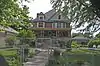 Christian Yegen House |
October 1, 1979 (#79003779) |
208 S. 35th St. 45°46′26″N 108°30′36″W / 45.7739°N 108.51°W |
Billings | |
| 45 | Peter Yegen House | 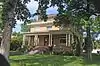 Peter Yegen House |
April 16, 1980 (#80002437) |
209 S. 35th St. 45°46′27″N 108°30′35″W / 45.7742°N 108.5097°W |
Billings |
See also
Wikimedia Commons has media related to National Register of Historic Places in Yellowstone County, Montana.
References
- ↑ The latitude and longitude information provided in this table was derived originally from the National Register Information System, which has been found to be fairly accurate for about 99% of listings. Some locations in this table may have been corrected to current GPS standards.
- ↑ National Park Service, United States Department of the Interior, "National Register of Historic Places: Weekly List Actions", retrieved January 12, 2024.
- ↑ Numbers represent an alphabetical ordering by significant words. Various colorings, defined here, differentiate National Historic Landmarks and historic districts from other NRHP buildings, structures, sites or objects.
- ↑ The eight-digit number below each date is the number assigned to each location in the National Register Information System database, which can be viewed by clicking the number.
- ↑ Samuel M. Thomas; John M. DeVitt (December 1, 1977). "National Register of Historic Places Inventory/Nomination: Historic Resources of Billings, Montana - Partial Inventory - Billings Townsite Historical District". National Park Service. Retrieved November 15, 2022. With accompanying 13 photos from 1978
- ↑ Ann Kooistra-Manning (March 6, 2006). "National Register of Historic Places Registration: Billings Townsite Historic District (Boundary Increase I)". National Park Service. Retrieved November 15, 2022. PDF includes two historic photos but not photos from 2006 taken to support the boundary increase.
- ↑ Billings Townsite Historic District, at Historic Montana
- ↑ "National Register of Historic Places document... Billings Old Town Historic District". National Park Service. THIS NPS TRY DOES NOT WORK, TRY NARA WHEN UP instead
- ↑ Billings Old Town Historic District, at Historic Montana
- ↑ Federal and state laws and practices restrict general public access to information regarding the specific location of this resource. In some cases, this is to protect archeological sites from vandalism, while in other cases it is restricted at the request of the owner. See: Knoerl, John; Miller, Diane; Shrimpton, Rebecca H. (1990), Guidelines for Restricting Information about Historic and Prehistoric Resources, National Register Bulletin, National Park Service, U.S. Department of the Interior, OCLC 20706997.
- ↑ Location derived from the house's website; the NRIS lists it as "Address Restricted"
| Lists by county |
|  |
|---|---|---|
| Other lists |
| |
Municipalities and communities of Yellowstone County, Montana, United States | ||
|---|---|---|
| Cities | Yellowstone County map | |
| Town | ||
| CDPs | ||
| Other communities | ||
| Indian reservation | ||
| Ghost towns | ||
| Footnotes | ‡This populated place also has portions in an adjacent county or counties | |
This article is issued from Wikipedia. The text is licensed under Creative Commons - Attribution - Sharealike. Additional terms may apply for the media files.