
Location of Tangipahoa Parish in Louisiana
This is a list of the National Register of Historic Places listings in Tangipahoa Parish, Louisiana.
This is intended to be a complete list of the properties and districts on the National Register of Historic Places in Tangipahoa Parish, Louisiana, United States. The locations of National Register properties and districts for which the latitude and longitude coordinates are included below, may be seen in a map.[1]
There are 32 properties and districts listed on the National Register in the parish. Another 5 properties were once listed but have been removed.
This National Park Service list is complete through NPS recent listings posted January 12, 2024.[2]
Current listings
| [3] | Name on the Register[4] | Image | Date listed[5] | Location | City or town | Description |
|---|---|---|---|---|---|---|
| 1 | Arcola Presbyterian Church | 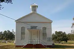 Arcola Presbyterian Church |
October 22, 1982 (#82000462) |
Church St. 30°46′34″N 90°31′04″W / 30.7761°N 90.5178°W |
Arcola | |
| 2 | Blythewood | 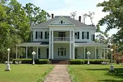 Blythewood |
June 25, 1982 (#82002795) |
205 Elm St. 30°43′51″N 90°29′55″W / 30.7308°N 90.4986°W |
Amite City | |
| 3 | Camp Moore |  Camp Moore |
August 21, 1979 (#79001092) |
Off Louisiana Highway 440 30°53′06″N 90°30′18″W / 30.885°N 90.505°W |
Tangipahoa vicinity | |
| 4 | Carter House | August 11, 1982 (#82002796) |
South of Hammond on Happywoods Rd. 30°28′31″N 90°29′33″W / 30.4753°N 90.4925°W |
Hammond vicinity | ||
| 5 | Cate House | 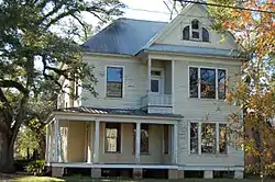 Cate House |
May 20, 1998 (#98000571) |
111 N. Magnolia St. 30°30′14″N 90°27′50″W / 30.5039°N 90.4639°W |
Hammond | |
| 6 | Downtown Amite Historic District | March 19, 1998 (#98000252) |
Roughly along Central Ave., Oak St., and Mulberry St. 30°43′35″N 90°30′32″W / 30.7264°N 90.5089°W |
Amite City | ||
| 7 | Episcopal Church of the Incarnation |  Episcopal Church of the Incarnation |
October 8, 1980 (#80001759) |
111 E. Olive St. 30°43′48″N 90°30′24″W / 30.73°N 90.5067°W |
Amite City | |
| 8 | Epney | June 21, 1984 (#84001362) |
Off Louisiana Highway 445 30°42′36″N 90°19′16″W / 30.71°N 90.3211°W |
Amite City vicinity | ||
| 9 | First Christian Church | August 2, 2017 (#100001433) |
305 E. Charles St. 30°30′22″N 90°27′31″W / 30.5060°N 90.4586°W |
Hammond | ||
| 10 | Grace Memorial Episcopal Church |  Grace Memorial Episcopal Church |
February 23, 1973 (#73000877) |
100 W. Church St. 30°30′57″N 90°27′45″W / 30.5158°N 90.4625°W |
Hammond | |
| 11 | Greater St. James AME Church | August 2, 2017 (#100001434) |
311 E. Michigan St. 30°30′35″N 90°27′33″W / 30.5098°N 90.4592°W |
Hammond | ||
| 12 | Green Shutters | 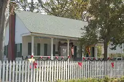 Green Shutters |
August 11, 1982 (#82002797) |
Franklin St. 30°52′25″N 90°30′33″W / 30.8736°N 90.5092°W |
Tangipahoa | |
| 13 | Greenlawn | 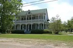 Greenlawn |
May 31, 1980 (#80001760) |
200 E. Chestnut St. 30°43′28″N 90°30′23″W / 30.7244°N 90.5064°W |
Amite City | |
| 14 | Hammond High School | 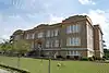 Hammond High School |
October 18, 1996 (#96001167) |
500 E. Thomas 30°30′16″N 90°27′20″W / 30.5044°N 90.4556°W |
Hammond | The building is no longer used by Hammond High School |
| 15 | Hammond Historic District | Hammond Historic District |
February 12, 1980 (#80001761) |
Roughly bounded by Magnolia, Robert, Cherry, and Morris Sts.; also Cypress St.; also portions of 19 blks. roughly centered on East Thomas St. and NW Railroad Ave. 30°30′18″N 90°27′41″W / 30.505°N 90.4614°W |
Hammond | See Hammond Historic District website; boundary changes were approved September 14, 2002 and September 29, 2022. |
| 16 | Husser School-Husser Community Center | December 28, 2020 (#100005986) |
56280 LA 445 30°40′19″N 90°19′51″W / 30.6719°N 90.3307°W |
Husser | ||
| 17 | Independence Historic District | October 5, 1982 (#82000463) |
Roughly bounded by Louisiana Highway 40, 5th St., Anzalone, and E. and W. Railroad Aves. 30°38′07″N 90°30′03″W / 30.6353°N 90.5008°W |
Independence | ||
| 18 | Charles Adolph Kent Sr. House |  Charles Adolph Kent Sr. House |
October 10, 1985 (#85003098) |
701 Ave., E. 30°56′21″N 90°30′59″W / 30.9392°N 90.5164°W |
Kentwood | |
| 19 | Miller Memorial Library | August 2, 2017 (#100001435) |
108 S. Pine St. 30°30′09″N 90°27′53″W / 30.5026°N 90.4647°W |
Hammond | ||
| 20 | McGehee Hall, Southeastern Louisiana University |  McGehee Hall, Southeastern Louisiana University |
January 18, 1985 (#85000094) |
Southeastern Louisiana University 30°30′41″N 90°28′02″W / 30.5114°N 90.4672°W |
Hammond | Oldest building on Southeastern Louisiana University's main campus |
| 21 | McGehee House | 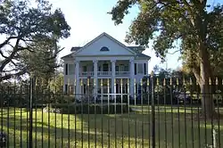 McGehee House |
November 2, 1982 (#82000465) |
1106 S. Holly St. 30°29′42″N 90°27′19″W / 30.495°N 90.4553°W |
Hammond | |
| 22 | Mount's Villa | January 31, 1985 (#85000163) |
Off Louisiana Highway 22 30°26′05″N 90°29′14″W / 30.434722°N 90.487222°W |
Ponchatoula vicinity | ||
| 23 | G. W. Nesom House | 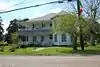 G. W. Nesom House |
August 29, 1997 (#97000965) |
50023 Louisiana Highway 51, N. 30°34′36″N 90°29′03″W / 30.576667°N 90.484167°W |
Tickfaw | |
| 24 | Nichols House | May 31, 1980 (#80001762) |
2 miles west of Ponchatoula on Louisiana Highway 22 30°26′25″N 90°28′24″W / 30.440278°N 90.473333°W |
Ponchatoula vicinity | ||
| 25 | Oaks Hotel | December 9, 1979 (#79001090) |
SW. Railroad Ave. 30°30′51″N 90°27′43″W / 30.514167°N 90.461944°W |
Hammond | ||
| 26 | Ponchatoula Commercial Historic District | 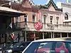 Ponchatoula Commercial Historic District |
October 5, 1982 (#82000466) |
Roughly bounded by 5th, 7th, Hickory, and Oak Sts. Boundary increase and decrease (listed July 25, 2012, refnum 12000426): 111, 180, 165, 138 N. 6th, 170, 175, 163-165, 138, 125 W. Hickory, 155 NW. Railroad Ave., 201, 245, 265, 275 W. Pine 30°26′19″N 90°26′32″W / 30.438611°N 90.442222°W |
Ponchatoula | |
| 27 | Randal House | 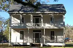 Randal House |
February 19, 2008 (#08000029) |
301 E. Michigan Ave. 30°30′41″N 90°27′36″W / 30.511389°N 90.46°W |
Hammond | |
| 28 | Reed Farmstead Log Dependencies | January 21, 1993 (#92001821) |
Louisiana Highway 445 30°40′56″N 90°19′38″W / 30.682222°N 90.327222°W |
Husser | ||
| 29 | Stevenson House | 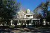 Stevenson House |
November 17, 1982 (#82000467) |
113 S. Pine 30°30′10″N 90°27′50″W / 30.502778°N 90.463889°W |
Hammond | |
| 30 | Tangipahoa School | 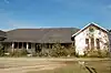 Tangipahoa School |
August 1, 2003 (#03000705) |
Junction of Jackson and Tarpley Sts. 30°52′37″N 90°30′47″W / 30.876944°N 90.513056°W |
Tangipahoa | |
| 31 | Wascom House | February 19, 2008 (#08000030) |
303 E. Michigan Ave. 30°30′41″N 90°27′35″W / 30.511389°N 90.459722°W |
Hammond | ||
| 32 | Zemurray Gardens Lodge Complex | October 3, 1983 (#83003637) |
Louisiana Highway 40 30°37′29″N 90°19′53″W / 30.624722°N 90.331389°W |
Loranger vicinity |
Former listings
| [3] | Name on the Register | Image | Date listed | Date removed | Location | City or town | Description |
|---|---|---|---|---|---|---|---|
| 1 | Dykes Log Cabin | September 12, 2002 (#02001036) | April 15, 2009 | 17250 State Line Rd. 30°59′55″N 90°26′29″W / 30.998611°N 90.441389°W |
Kentwood vicinity | Delisted after being moved to an unknown location out of state. | |
| 2 | June House | March 31, 1983 (#83000546) | May 2, 2016 | 408 E. Coleman Ave. 30°30′01″N 90°27′20″W / 30.500278°N 90.455556°W |
Hammond | ||
| 3 | Loranger Methodist Church | October 5, 1982 (#82000464) | March 31, 2015 | Allman Ave. and Magnolia Boulevard 30°38′22″N 90°24′01″W / 30.639444°N 90.400278°W |
Loranger | ||
| 4 | Pass Manchac Light |  Pass Manchac Light |
July 9, 1986 (#86001554) | January 31, 2019 | Western end of Lake Pontchartrain 30°17′48″N 90°17′52″W / 30.296667°N 90.297778°W |
Ponchatoula vicinity | 1857 masonry structure gradually encroached upon by lake waters & finally destroyed by Hurricane Isaac (2012).[6] |
| 5 | Tangipahoa Parish Training School Dormitory | July 27, 1979 (#79001091) | January 31, 2019 | Off Louisiana Highway 38 30°55′52″N 90°30′47″W / 30.931111°N 90.513056°W |
Kentwood |
See also
Wikimedia Commons has media related to National Register of Historic Places in Tangipahoa Parish, Louisiana.
References
- ↑ The latitude and longitude information provided in this table was derived originally from the National Register Information System, which has been found to be fairly accurate for about 99% of listings. Some locations in this table may have been corrected to current GPS standards.
- ↑ National Park Service, United States Department of the Interior, "National Register of Historic Places: Weekly List Actions", retrieved January 12, 2024.
- 1 2 Numbers represent an alphabetical ordering by significant words. Various colorings, defined here, differentiate National Historic Landmarks and historic districts from other NRHP buildings, structures, sites or objects.
- ↑ "National Register Information System". National Register of Historic Places. National Park Service. March 13, 2009.
- ↑ The eight-digit number below each date is the number assigned to each location in the National Register Information System database, which can be viewed by clicking the number.
- ↑ "Historic lighthouse destroyed by Isaac". The Town Talk (Alexandria). September 24, 2012. p. A3. Retrieved July 5, 2022 – via Newspapers.com.
| Topics | |
|---|---|
| Lists by state |
|
| Lists by insular areas | |
| Lists by associated state | |
| Other areas | |
| Related | |
Municipalities and communities of Tangipahoa Parish, Louisiana, United States | ||
|---|---|---|
| Cities | | |
| Towns | ||
| Villages | ||
| CDP | ||
| Other Unincorporated communities | ||
This article is issued from Wikipedia. The text is licensed under Creative Commons - Attribution - Sharealike. Additional terms may apply for the media files.