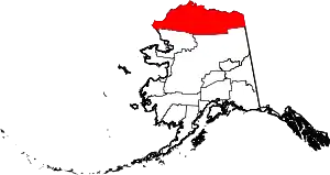
Location of the North Slope Borough in Alaska
This is a list of the National Register of Historic Places listings in North Slope Borough, Alaska.
This is intended to be a complete list of the properties and districts on the National Register of Historic Places in North Slope Borough, Alaska, United States. The locations of National Register properties and districts for which the latitude and longitude coordinates are included below, may be seen in a Google map.[1]
There are 18 properties and districts listed on the National Register in the borough, including 4 National Historic Landmarks.
This National Park Service list is complete through NPS recent listings posted January 12, 2024.[2]
Current listings
| [3] | Name on the Register[4] | Image | Date listed[5] | Location | City or town | Description |
|---|---|---|---|---|---|---|
| 1 | Aluakpak | March 18, 1980 (#80004555) |
About 15 miles (24 km) south of Wainwright 70°25′12″N 159°51′09″W / 70.42007°N 159.85245°W |
Wainwright | ||
| 2 | Anaktuuk | March 18, 1980 (#80004556) |
Address restricted[6] |
Wainwright | ||
| 3 | Atanik | March 18, 1980 (#80004557) |
On the shoreline of the Chukchi Sea, 20 miles (32 km) northeast of Wainwright[7] 70°50′35″N 159°21′36″W / 70.843056°N 159.360000°W |
Wainwright | ||
| 4 | Avalitkuk | March 18, 1980 (#80004558) |
Address restricted[6] |
Wainwright | ||
| 5 | Birnirk site | Birnirk site |
October 15, 1966 (#66000953) |
Address restricted[6] |
Barrow | |
| 6 | Gallagher Flint Station Archeological Site |  Gallagher Flint Station Archeological Site |
June 16, 1978 (#78003208) |
Address restricted[6] |
Sagwon | |
| 7 | Ipiutak Archeological District | May 25, 1979 (#79000411) |
Address restricted[6] |
Point Hope | ||
| 8 | Ipiutak site | 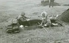 Ipiutak site |
October 15, 1966 (#66000157) |
Address restricted[6] |
Point Hope | |
| 9 | Ivishaat | March 18, 1980 (#80004559) |
Address restricted[6] |
Wainwright | ||
| 10 | Kanitch | March 18, 1980 (#80004560) |
Address restricted[6] |
Wainwright | ||
| 11 | Leffingwell Camp Site |  Leffingwell Camp Site |
June 21, 1971 (#71001093) |
About 58 miles (93 km) west of Kaktovik 70°11′07″N 146°03′10″W / 70.1852°N 146.05287°W |
Flaxman Island | |
| 12 | Napanik | March 18, 1980 (#80004561) |
Address restricted[6] |
Wainwright | ||
| 13 | Negilik Site | April 15, 1980 (#80004562) |
Address restricted[6] |
Wainwright | ||
| 14 | Point Barrow Refuge Station | 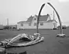 Point Barrow Refuge Station |
December 2, 1980 (#80004563) |
Along Brower Street, Browersville 71°17′54″N 156°46′23″W / 71.29839°N 156.77305°W |
Barrow | |
| 15 | Prudhoe Bay Oil Field Discovery Well Site | March 23, 2000 (#00000264) |
About 1.5 miles (2.4 km) northwest of Putuligayuk River mouth, along western shore of Prudhoe Bay 70°19′27″N 148°32′28″W / 70.32408°N 148.54116°W |
Prudhoe Bay | ||
| 16 | Rogers-Post Site | 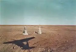 Rogers-Post Site |
April 22, 1980 (#80004564) |
Near Walakpa River mouth, about 11 miles (18 km) southwest of Barrow 71°09′15″N 157°03′50″W / 71.15412°N 157.064°W |
Barrow | |
| 17 | Utkeagvik Church Manse | 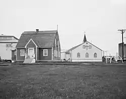 Utkeagvik Church Manse |
October 6, 1983 (#83003447) |
1268 Church Street 71°17′34″N 156°47′00″W / 71.29278°N 156.78326°W |
Barrow | |
| 18 | Uyagaagruk | March 18, 1980 (#80004565) |
Address restricted[6] |
Wainwright |
See also
Wikimedia Commons has media related to National Register of Historic Places in North Slope Borough, Alaska.
References
- ↑ The latitude and longitude information provided in this table was derived originally from the National Register Information System, which has been found to be fairly accurate for about 99% of listings. Some locations in this table may have been corrected to current GPS standards.
- ↑ National Park Service, United States Department of the Interior, "National Register of Historic Places: Weekly List Actions", retrieved January 12, 2024.
- ↑ Numbers represent an alphabetical ordering by significant words. Various colorings, defined here, differentiate National Historic Landmarks and historic districts from other NRHP buildings, structures, sites or objects.
- ↑ "National Register Information System". National Register of Historic Places. National Park Service. April 24, 2008.
- ↑ The eight-digit number below each date is the number assigned to each location in the National Register Information System database, which can be viewed by clicking the number.
- 1 2 3 4 5 6 7 8 9 10 11 Federal and state laws and practices restrict general public access to information regarding the specific location of this resource. In some cases, this is to protect archeological sites from vandalism, while in other cases it is restricted at the request of the owner. See: Knoerl, John; Miller, Diane; Shrimpton, Rebecca H. (1990), Guidelines for Restricting Information about Historic and Prehistoric Resources, National Register Bulletin, National Park Service, U.S. Department of the Interior, OCLC 20706997.
- ↑ Location derived from its GNIS feature record; the NRIS lists the site as "Address Restricted"
| Topics | |
|---|---|
| Lists by state |
|
| Lists by insular areas | |
| Lists by associated state | |
| Other areas | |
| Related | |
Boroughs | .svg.png.webp) | ||
Census areas | |||
There are no sites listed on the National Register of Historic Places in Kusilvak Census Area. | |||
Municipalities and communities of North Slope Borough, Alaska, United States | ||
|---|---|---|
| Cities | North Slope Borough map | |
| CDPs | ||
| Unincorporated communities | ||
| Ghost towns | ||
This article is issued from Wikipedia. The text is licensed under Creative Commons - Attribution - Sharealike. Additional terms may apply for the media files.