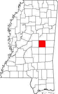
Location of Neshoba County in Mississippi
This is a list of the National Register of Historic Places listings in Neshoba County, Mississippi.
This is intended to be a complete list of the properties and districts on the National Register of Historic Places in Neshoba County, Mississippi, United States. Latitude and longitude coordinates are provided for many National Register properties and districts; these locations may be seen together in a map.[1]
There are 7 properties and districts listed on the National Register in the county.
This National Park Service list is complete through NPS recent listings posted December 22, 2023.[2]
Current listings
| [3] | Name on the Register | Image | Date listed[4] | Location | City or town | Description |
|---|---|---|---|---|---|---|
| 1 | Downtown Philadelphia Historic District | 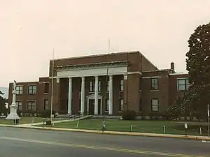 Downtown Philadelphia Historic District |
April 14, 2005 (#05000280) |
Roughly bounded by Myrtle, Peachtree, Walnut, and Pecan 32°46′17″N 89°06′36″W / 32.771389°N 89.11°W |
Philadelphia | |
| 2 | Mt. Zion Methodist Church | Mt. Zion Methodist Church |
July 13, 2018 (#100001029) |
11191 Cty. Rd. 747 32°46′54″N 88°59′30″W / 32.781531°N 88.991642°W |
Philadelphia | |
| 3 | Nanih Waiya Cave Mound | 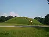 Nanih Waiya Cave Mound |
May 7, 1973 (#73001023) |
Address restricted[5] |
Philadelphia | |
| 4 | Neshoba County Fair Historic District | 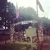 Neshoba County Fair Historic District |
April 22, 1980 (#80002294) |
Northwest of Neshoba on Mississippi Highway 21 32°42′49″N 89°12′47″W / 32.713611°N 89.213056°W |
Neshoba | Entrance into the Neshoba County Fairgrounds |
| 5 | Philadelphia Historic District | .jpg.webp) Philadelphia Historic District |
March 4, 1983 (#83000964) |
Holland and Poplar Aves. and Jefferson, Watkins, and Welsh Sts. 32°46′07″N 89°06′24″W / 32.768611°N 89.1067°W |
Philadelphia | |
| 6 | Old US Post Office (Philadelphia) | .jpg.webp) Old US Post Office (Philadelphia) |
June 30, 1995 (#95000788) |
523 Main Street 32°46′14″N 89°06′32″W / 32.7706°N 89.1089°W |
Philadelphia | Constructed 1935-36, serves as Philadelphia Police Station |
| 7 | Booker T. Washington High School | Booker T. Washington High School |
September 2, 2021 (#100006878) |
234 Carver Ave. 32°46′45″N 89°07′04″W / 32.7792°N 89.1178°W |
Philadelphia |
See also
Wikimedia Commons has media related to National Register of Historic Places in Neshoba County, Mississippi.
References
- ↑ The latitude and longitude information provided in this table was derived originally from the National Register Information System, which has been found to be fairly accurate for about 99% of listings. Some locations in this table may have been corrected to current GPS standards.
- ↑ National Park Service, United States Department of the Interior, "National Register of Historic Places: Weekly List Actions", retrieved December 22, 2023.
- ↑ Numbers represent an alphabetical ordering by significant words. Various colorings, defined here, differentiate National Historic Landmarks and historic districts from other NRHP buildings, structures, sites or objects.
- ↑ The eight-digit number below each date is the number assigned to each location in the National Register Information System database, which can be viewed by clicking the number.
- ↑ Federal and state laws and practices restrict general public access to information regarding the specific location of this resource. In some cases, this is to protect archeological sites from vandalism, while in other cases it is restricted at the request of the owner. See: Knoerl, John; Miller, Diane; Shrimpton, Rebecca H. (1990), Guidelines for Restricting Information about Historic and Prehistoric Resources, National Register Bulletin, National Park Service, U.S. Department of the Interior, OCLC 20706997.
Municipalities and communities of Neshoba County, Mississippi, United States | ||
|---|---|---|
| Cities | Map of Mississippi highlighting Neshoba County | |
| Town | ||
| CDPs | ||
| Other communities | ||
| Indian reservation | ||
| Footnotes | ‡This populated place also has portions in an adjacent county or counties | |
| Topics | |
|---|---|
| Lists by state |
|
| Lists by insular areas | |
| Lists by associated state | |
| Other areas | |
| Related | |
This article is issued from Wikipedia. The text is licensed under Creative Commons - Attribution - Sharealike. Additional terms may apply for the media files.