This is a list of the National Register of Historic Places listings in Lincoln County, New Mexico.
This is intended to be a complete list of the properties and districts on the National Register of Historic Places in Lincoln County, New Mexico, United States. Latitude and longitude coordinates are provided for many National Register properties and districts; these locations may be seen together in a map.[1]
There are 34 properties and districts listed on the National Register in the county, including 1 National Historic Landmark. All of the places within the county on the National Register are also listed on the State Register of Cultural Properties with the single exception of the Lincoln Historic District although the landmark includes one contributing property recorded on the state register. NRHP properties within the county include two of the state's eight officially designated state historic sites.
This National Park Service list is complete through NPS recent listings posted December 22, 2023.[2]
| Bernalillo – Catron – Chaves – Cibola – Colfax – Curry – De Baca – Doña Ana – Eddy – Grant – Guadalupe – Harding – Hidalgo – Lea – Lincoln – Los Alamos – Luna – McKinley – Mora – Otero – Quay – Rio Arriba – Roosevelt – San Juan – San Miguel – Sandoval – Santa Fe – Sierra – Socorro – Taos – Torrance – Union – Valencia |
Current listings
| [3] | Name on the Register[4] | Image | Date listed[5] | Location | City or town | Description |
|---|---|---|---|---|---|---|
| 1 | Aguayo Family Homestead | December 28, 1995 (#95001478) |
Tortolita Canyon, west of Nogal 33°32′06″N 105°45′09″W / 33.535°N 105.7525°W |
Nogal | ||
| 2 | Archeological Site LA 12151 | September 13, 1988 (#88001507) |
Address Restricted |
Lincoln | ||
| 3 | Archeological Site LA 12153 | February 18, 1990 (#88001508) |
Address Restricted |
Lincoln | ||
| 4 | Archeological Site LA 12155 | February 18, 1990 (#88001509) |
Address Restricted |
Lincoln | ||
| 5 | Archeological Site LA 61201 | September 13, 1988 (#88001510) |
Address Restricted |
Lincoln | ||
| 6 | Archeological Site LA 61202 | February 18, 1990 (#88001511) |
Address Restricted |
Lincoln | ||
| 7 | Archeological Site LA 61204 | September 13, 1988 (#88001512) |
Address Restricted |
Lincoln | ||
| 8 | Archeological Site LA 61206 | September 13, 1988 (#88001513) |
Address Restricted |
Lincoln | ||
| 9 | Archeological Site LA 61208 | September 13, 1988 (#88001514) |
Address Restricted |
Lincoln | ||
| 10 | Archeological Site LA 61210 | September 13, 1988 (#88001516) |
Address Restricted |
Lincoln | ||
| 11 | Archeological Site LA 61211 | September 13, 1988 (#88001515) |
Address Restricted |
Lincoln | ||
| 12 | Archeological Site No. AR-03-08-01-051 | August 28, 1990 (#90001251) |
Address Restricted |
White Oaks | ||
| 13 | Archeological Site No. AR-03-08-01-052 | August 28, 1990 (#90001252) |
Address Restricted |
White Oaks | ||
| 14 | Carrizozo Commercial Historic District | August 22, 2016 (#16000550) |
Roughly bounded by Brick & D Aves., 11th & 13th Sts. 33°38′36″N 105°52′32″W / 33.643406°N 105.875608°W |
Carrizozo | ||
| 15 | Carrizozo Woman's Club | 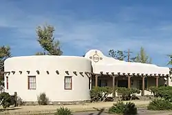 Carrizozo Woman's Club |
October 6, 2003 (#03000995) |
908 11th St. 33°38′33″N 105°52′43″W / 33.6425°N 105.878611°W |
Carrizozo | |
| 16 | El Paso And Southwestern Railway Water Supply System | November 21, 1979 (#79001540) |
South of Nogal 33°29′30″N 105°40′44″W / 33.491667°N 105.678889°W |
Nogal | ||
| 17 | Feather Cave | November 20, 1974 (#74001198) |
Address Restricted |
Lincoln | ||
| 18 | Fort Stanton | 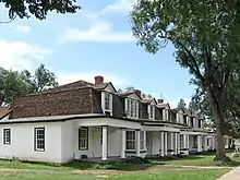 Fort Stanton |
April 13, 1973 (#73001142) |
7 miles southeast of Capitan near U.S. Route 380 33°29′40″N 105°31′35″W / 33.494444°N 105.526389°W |
Capitan | State Historic Site |
| 19 | Funston Site (AR-03-08-01-046) | August 28, 1990 (#90001250) |
Address Restricted |
White Oaks | ||
| 20 | Hopeful Lode | August 22, 1995 (#95001014) |
Along Forest Rd. 108, 6 miles north of the junction of Forest Rds. 107 and 108, north of Bonito Lake 33°29′19″N 105°46′55″W / 33.488611°N 105.781944°W |
Nogal | ||
| 21 | Peter and Henriette Wyeth Hurd House | 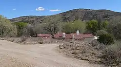 Peter and Henriette Wyeth Hurd House |
December 10, 2014 (#14001015) |
129 La Mancha Ln. 33°24′13″N 105°19′47″W / 33.403675°N 105.329725°W |
San Patricio | |
| 22 | Jicarilla Schoolhouse | 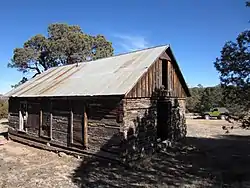 Jicarilla Schoolhouse |
April 14, 1983 (#83001623) |
State Road 349 in the Lincoln National Forest 33°51′40″N 105°39′16″W / 33.861111°N 105.654444°W |
Jicarilla | |
| 23 | Luis A. and Susan B. Jimenez House and Studios | December 10, 2014 (#14001016) |
Address Restricted |
Hondo | ||
| 24 | Lincoln Historic District | .jpg.webp) Lincoln Historic District |
October 15, 1966 (#66000477) |
U.S. Route 380 33°29′41″N 105°22′56″W / 33.494722°N 105.382222°W |
Lincoln | State Historic Site |
| 25 | Mesa Ranger Station Site | October 22, 1990 (#90001533) |
Address Restricted |
Nogal | ||
| 26 | Monjeau Lookout | 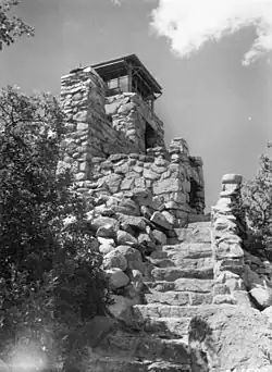 Monjeau Lookout |
January 27, 1988 (#87002483) |
Lincoln National Forest 33°25′51″N 105°43′53″W / 33.430833°N 105.731389°W |
Villa Madonna | |
| 27 | New Mexico Military Institute Summer Camp, Main Building | May 2, 1983 (#83001622) |
Carrizo Canyon 33°18′22″N 105°40′08″W / 33.306111°N 105.668889°W |
Ruidoso | ||
| 28 | Nogal Mesa Kiva Site | October 22, 1990 (#90001532) |
Address Restricted |
Nogal | ||
| 29 | Nogal Mesa Site | October 22, 1990 (#90001531) |
Address Restricted |
Nogal | ||
| 30 | Old Dowlin Mill | 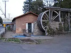 Old Dowlin Mill |
September 25, 2013 (#13000768) |
641 Sudderth Dr. 33°19′25″N 105°38′51″W / 33.323644°N 105.647578°W |
Ruidoso | |
| 31 | Paden's Drug Store | 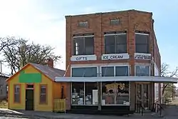 Paden's Drug Store |
March 23, 2005 (#05000204) |
1200-1208 E Ave. 33°38′35″N 105°52′42″W / 33.643056°N 105.878333°W |
Carrizozo | Now Roy's Ice Cream Parlour |
| 32 | Ruidoso Lookout Tower | January 27, 1988 (#87002485) |
Lincoln National Forest 33°19′54″N 105°39′43″W / 33.331667°N 105.661944°W |
Ruidoso | ||
| 33 | White Oaks Historic District |  White Oaks Historic District |
September 4, 1970 (#70000403) |
12 miles northeast of Carrizozo on State Road 349 33°45′03″N 105°45′22″W / 33.750833°N 105.756111°W |
White Oaks | |
| 34 | Wizard's Roost | August 2, 1982 (#82004841) |
Address Restricted |
Capitan |
See also
References
- ↑ The latitude and longitude information provided in this table was derived originally from the National Register Information System, which has been found to be fairly accurate for about 99% of listings. Some locations in this table may have been corrected to current GPS standards.
- ↑ National Park Service, United States Department of the Interior, "National Register of Historic Places: Weekly List Actions", retrieved December 22, 2023.
- ↑ Numbers represent an alphabetical ordering by significant words. Various colorings, defined here, differentiate National Historic Landmarks and historic districts from other NRHP buildings, structures, sites or objects.
- ↑ "National Register Information System". National Register of Historic Places. National Park Service. April 24, 2008.
- ↑ The eight-digit number below each date is the number assigned to each location in the National Register Information System database, which can be viewed by clicking the number.
| Topics | |
|---|---|
| Lists by state |
|
| Lists by insular areas | |
| Lists by associated state | |
| Other areas | |
| Related | |
Municipalities and communities of Lincoln County, New Mexico, United States | ||
|---|---|---|
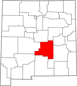
| City | Map of New Mexico highlighting Lincoln County | |
| Town | ||
| Villages | ||
| CDP | ||
| Other unincorporated communities | ||
| Ghost towns | ||