
Location of Hughes County in South Dakota
This is a list of the National Register of Historic Places listings in Hughes County, South Dakota.
This is intended to be a complete list of the properties and districts on the National Register of Historic Places in Hughes County, South Dakota, United States. The locations of National Register properties and districts for which the latitude and longitude coordinates are included below, may be seen in a map.[1]
There are 43 properties and districts listed on the National Register in the county, including 1 National Historic Landmark.
This National Park Service list is complete through NPS recent listings posted January 12, 2024.[2]
Current listings
| [3] | Name on the Register[4] | Image | Date listed[5] | Location | City or town | Description |
|---|---|---|---|---|---|---|
| 1 | Archeological Site 39HU66 | February 23, 1984 (#84003297) |
Address restricted[6] |
Canning | part of the Petroforms of South Dakota Thematic Resource (TR) | |
| 2 | Archeological Site 39HU189 | February 23, 1984 (#84003307) |
Address restricted[6] |
Macs Corner | part of the Petroforms of South Dakota TR | |
| 3 | Archeological Site 39HU201 | February 23, 1984 (#84003308) |
Address restricted[6] |
Pierre | part of the Petroforms of South Dakota TR | |
| 4 | Arzberger site | 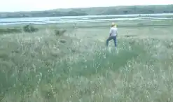 Arzberger site |
October 15, 1966 (#66000715) |
Atop the bluff above the McClure Site[7]: 3 44°20′54″N 100°11′48″W / 44.348333°N 100.196667°W |
Pierre | |
| 5 | Dr. William and Elizabeth Blackburn House | 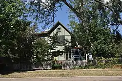 Dr. William and Elizabeth Blackburn House |
May 9, 1997 (#97000426) |
219 S. Tyler Ave. 44°21′44″N 100°19′37″W / 44.362222°N 100.326944°W |
Pierre | |
| 6 | Brink-Wegner House | 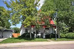 Brink-Wegner House |
April 26, 1978 (#78002557) |
110 E. 4th St. 44°22′44″N 100°20′56″W / 44.378924°N 100.348994°W |
Pierre | |
| 7 | Cedar Islands Archeological District | August 14, 1986 (#86002739) |
Address restricted[6] |
Pierre | part of the Big Bend Area Multiple Resource Area (MRA) | |
| 8 | Central Block | 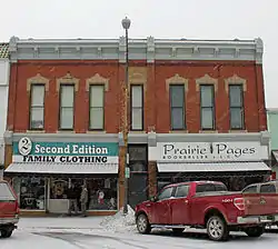 Central Block |
January 19, 1989 (#88003201) |
321-325 S. Pierre St. 44°21′56″N 100°21′19″W / 44.365556°N 100.355278°W |
Pierre | |
| 9 | Chicago and North Western Railroad Bridge | 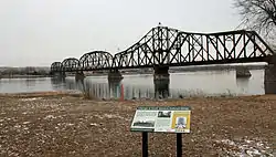 Chicago and North Western Railroad Bridge |
November 19, 1998 (#98001412) |
North of U.S. Routes 14/83 over the Missouri River 44°22′25″N 100°22′12″W / 44.373611°N 100.37°W |
Pierre | part of the Historic Railroads of South Dakota Multiple Property Submission (MPS) |
| 10 | Crawford-Pettyjohn House | 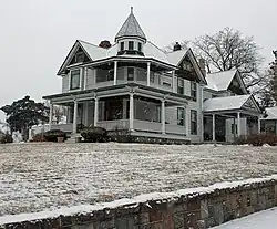 Crawford-Pettyjohn House |
September 22, 1977 (#77001245) |
129 S. Washington St. 44°21′49″N 100°20′09″W / 44.363611°N 100.335833°W |
Pierre | |
| 11 | Farr House | 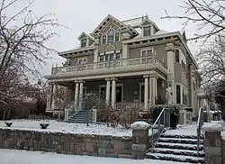 Farr House |
December 4, 1980 (#80003723) |
106 E. Wynoka St. 44°22′17″N 100°20′56″W / 44.371389°N 100.348889°W |
Pierre | |
| 12 | Fort George Creek Archeological District | August 14, 1986 (#86002741) |
Address restricted[6] |
Pierre | part of the Big Bend Area MRA | |
| 13 | Celina and Albert Goddard House | 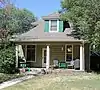 Celina and Albert Goddard House |
February 16, 2018 (#100002102) |
111 S Van Buren 44°21′50″N 100°19′53″W / 44.364010°N 100.331385°W |
Pierre | |
| 14 | I. W. Goodner House | 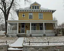 I. W. Goodner House |
March 23, 1995 (#95000278) |
216 E. Prospect Ave. 44°22′44″N 100°20′59″W / 44.378889°N 100.349722°W |
Pierre | |
| 15 | Mentor Graham House | 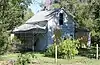 Mentor Graham House |
December 13, 1976 (#76001736) |
U.S. Route 14 44°30′45″N 99°59′22″W / 44.5125°N 99.989444°W |
Blunt | |
| 16 | Peter Hansen House | 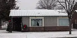 Peter Hansen House |
February 10, 1999 (#98001410) |
1123 E. Capitol St. 44°22′23″N 100°20′09″W / 44.373056°N 100.335833°W |
Pierre | part of the Lustron Houses in South Dakota MPS |
| 17 | Harrold School | October 24, 2003 (#03001073) |
206 S. Nixon Ave. 44°31′29″N 99°44′01″W / 44.524722°N 99.733611°W |
Harrold | part of the Schools in South Dakota MPS | |
| 18 | Hilger Block | 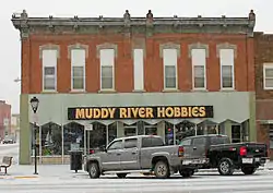 Hilger Block |
May 31, 2006 (#06000456) |
361 S. Pierre 44°22′05″N 100°21′19″W / 44.368056°N 100.355278°W |
Pierre | |
| 19 | John E. and Ruth Hipple House | 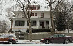 John E. and Ruth Hipple House |
June 6, 2001 (#01000641) |
219 N. Highland 44°22′09″N 100°20′51″W / 44.369167°N 100.3475°W |
Pierre | |
| 20 | Horner-Hyde House | 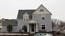 Horner-Hyde House |
December 20, 1988 (#88002836) |
100 W. Capitol Ave. 44°22′10″N 100°21′05″W / 44.369444°N 100.351389°W |
Pierre | |
| 21 | Hughes County Courthouse |  Hughes County Courthouse |
February 10, 1993 (#92001859) |
Capitol Ave. between Grand and Euclid Aves. 44°22′09″N 100°21′02″W / 44.369167°N 100.350556°W |
Pierre | part of the County Courthouses of South Dakota MPS |
| 22 | Hyde Buildings | 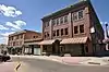 Hyde Buildings |
February 1, 1983 (#83003009) |
101½, 105, 108½, and 109 S. Pierre St., and 105½ Capitol Ave. 44°22′07″N 100°21′05″W / 44.368611°N 100.351389°W |
Pierre | |
| 23 | Karcher Block | 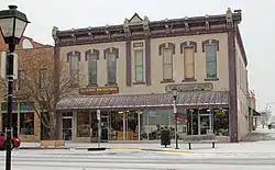 Karcher Block |
August 17, 1993 (#93000783) |
366 S. Pierre St. 44°21′57″N 100°21′16″W / 44.365833°N 100.354444°W |
Pierre | |
| 24 | Karcher-Sahr House | 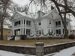 Karcher-Sahr House |
September 22, 1977 (#77001246) |
222 E. Prospect St. 44°22′09″N 100°20′45″W / 44.369167°N 100.345833°W |
Pierre | |
| 25 | McClure Site (39HU7) |  McClure Site (39HU7) |
August 14, 1986 (#86002732) |
Southern side of Highway 34 in the SE¼ NE¼ NW¼ of Section 15, T110N R78W[7]: 4 44°20′09″N 100°12′00″W / 44.335833°N 100.20000°W |
Pierre | part of the Big Bend Area MRA |
| 26 | Henry M. McDonald House | 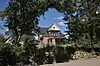 Henry M. McDonald House |
October 19, 1989 (#89001718) |
1906 E. Erskine 44°21′48″N 100°19′30″W / 44.363333°N 100.325°W |
Pierre | |
| 27 | George McMillen House | 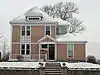 George McMillen House |
August 18, 1983 (#83003010) |
111 E. Broadway 44°22′15″N 100°20′58″W / 44.370833°N 100.349444°W |
Pierre | |
| 28 | Judge C. D. Meade House | 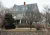 Judge C. D. Meade House |
October 7, 1977 (#77001247) |
106 W. Prospect St. 44°22′13″N 100°21′02″W / 44.370278°N 100.350556°W |
Pierre | |
| 29 | Medicine Creek Archeological District | August 14, 1986 (#86002740) |
Address restricted[6] |
Lower Brule | Extends into Lyman County; part of the Big Bend Area MRA | |
| 30 | Methodist Episcopal Church |  Methodist Episcopal Church |
May 9, 1997 (#97000428) |
117 Central Ave., N. 44°22′16″N 100°21′12″W / 44.371111°N 100.353333°W |
Pierre | |
| 31 | Oahe Addition Historic District | 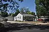 Oahe Addition Historic District |
June 2, 2000 (#00000599) |
Roughly bounded by N. Poplar, LaBarge Ct., and 3rd and 4th Sts. 44°22′43″N 100°21′26″W / 44.378611°N 100.357222°W |
Pierre | |
| 32 | Oahe Chapel | 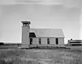 Oahe Chapel |
June 6, 1980 (#80003725) |
Northwest of Pierre 44°27′29″N 100°23′08″W / 44.458056°N 100.385556°W |
Pierre | |
| 33 | Old Fort Sully Site (39HU52) |  Old Fort Sully Site (39HU52) |
August 14, 1986 (#86002731) |
Farm Island Recreation Area[8] 44°20′43″N 100°16′28″W / 44.345320°N 100.274321°W |
Pierre | part of the Big Bend Area MRA |
| 34 | Pierre American Legion Cabin |  Pierre American Legion Cabin |
June 27, 2019 (#100004127) |
520 S. Pierre St. 44°21′50″N 100°21′25″W / 44.3640°N 100.3569°W |
Pierre | |
| 34 | Pierre Hill Residential Historic District | 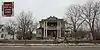 Pierre Hill Residential Historic District |
February 23, 1998 (#98000075) |
Roughly bounded by Huron Ave., Elizabeth St., Euclid Ave., and Broadway 44°22′20″N 100°20′52″W / 44.372222°N 100.347778°W |
Pierre | |
| 35 | Pierre Masonic Lodge | 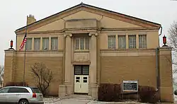 Pierre Masonic Lodge |
June 10, 2009 (#09000447) |
210 W. Capitol Ave. 44°22′11″N 100°21′12″W / 44.369798°N 100.353286°W |
Pierre | |
| 36 | Pringle House | 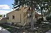 Pringle House |
August 7, 2012 (#12000485) |
102 N. Jefferson 44°22′04″N 100°20′13″W / 44.36772°N 100.337065°W |
Pierre | |
| 37 | Rowe House | 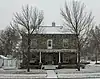 Rowe House |
February 9, 2001 (#01000095) |
1118 E. Capitol 44°21′52″N 100°20′08″W / 44.364444°N 100.335556°W |
Pierre | |
| 38 | St. Charles Hotel | 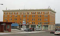 St. Charles Hotel |
May 7, 1980 (#80003724) |
207 E. Capitol Ave. 44°22′06″N 100°21′01″W / 44.368333°N 100.350278°W |
Pierre | |
| 39 | Kenneth R. Scurr House | 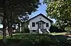 Kenneth R. Scurr House |
August 5, 1993 (#93000780) |
121 S. Washington Ave. 44°21′54″N 100°19′36″W / 44.365°N 100.326667°W |
Pierre | |
| 40 | Soldiers & Sailors World War Memorial | Soldiers & Sailors World War Memorial |
January 27, 1983 (#83003011) |
Capitol Ave. 44°21′58″N 100°20′49″W / 44.366111°N 100.346944°W |
Pierre | |
| 41 | South Dakota State Capitol |  South Dakota State Capitol |
September 1, 1976 (#76001737) |
Bounded by Broadway, Washington, and Capitol Aves. 44°22′43″N 100°21′17″W / 44.378611°N 100.354722°W |
Pierre | |
| 42 | Stephens-Lucas House | 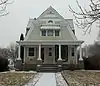 Stephens-Lucas House |
May 26, 1977 (#77001248) |
123 N. Nicollette 44°22′07″N 100°20′43″W / 44.368611°N 100.345278°W |
Pierre |
Former listings
| [3] | Name on the Register | Image | Date listed | Date removed | Location | City or town | Description |
|---|---|---|---|---|---|---|---|
| 1 | Brandhuber Ice Company Barn | October 22, 1980 (#80003722) | April 11, 1997 | 419 S. Fort St. |
Pierre | Destroyed by fire on April 5, 1995.[9] |
See also
Wikimedia Commons has media related to National Register of Historic Places in Hughes County, South Dakota.
References
- ↑ The latitude and longitude information provided in this table was derived originally from the National Register Information System, which has been found to be fairly accurate for about 99% of listings. Some locations in this table may have been corrected to current GPS standards.
- ↑ National Park Service, United States Department of the Interior, "National Register of Historic Places: Weekly List Actions", retrieved January 12, 2024.
- 1 2 Numbers represent an alphabetical ordering by significant words. Various colorings, defined here, differentiate National Historic Landmarks and historic districts from other NRHP buildings, structures, sites or objects.
- ↑ "National Register Information System". National Register of Historic Places. National Park Service. April 24, 2008.
- ↑ The eight-digit number below each date is the number assigned to each location in the National Register Information System database, which can be viewed by clicking the number.
- 1 2 3 4 5 6 Federal and state laws and practices restrict general public access to information regarding the specific location of this resource. In some cases, this is to protect archeological sites from vandalism, while in other cases it is restricted at the request of the owner. See: Knoerl, John; Miller, Diane; Shrimpton, Rebecca H. (1990), Guidelines for Restricting Information about Historic and Prehistoric Resources, National Register Bulletin, National Park Service, U.S. Department of the Interior, OCLC 20706997.
- 1 2 "The McClure Site and Excavated Features the [sic] Site". Plains Anthropologist 27.98 (1982): 3-14.
- ↑ "Dakota Forts". State of South Dakota. Retrieved 2017-05-19.
- ↑ "Historic barn destroyed by fire". Argus Leader. April 6, 1995. p. 4D. Retrieved August 27, 2022 – via Newspapers.com.

Municipalities and communities of Hughes County, South Dakota, United States | ||
|---|---|---|
| Cities | Hughes County map | |
| Town | ||
| Township | ||
| Indian reservation | ||
| CDP | ||
| Other communities | ||
| Footnotes | ‡This populated place also has portions in an adjacent county or counties | |
This article is issued from Wikipedia. The text is licensed under Creative Commons - Attribution - Sharealike. Additional terms may apply for the media files.