This is intended to be a complete list of properties and districts listed on the National Register of Historic Places that are located in the Houston Heights neighborhood of Houston. The "Houston Heights" neighborhood borders are, approximately, Interstate 10 on the South, I-610 on the North, Interstate 45 on the East and Durham on the West.
The locations of National Register properties and districts (at least for all showing latitude and longitude coordinates below) may be seen in a map by clicking on "Map of all coordinates."[1]
| downtown Houston - Houston Heights - inner Harris County - outer Harris County |
This National Park Service list is complete through NPS recent listings posted January 12, 2024.[2]
Current listings
| [3] | Name on the Register | Image | Date listed[4] | Location | City or town | Description |
|---|---|---|---|---|---|---|
| 1 | All Saints Roman Catholic Church | 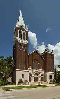 All Saints Roman Catholic Church |
June 22, 1983 (#83004425) |
201 E. 10th St. 29°47′21″N 95°23′46″W / 29.78912°N 95.39612°W |
Houston | |
| 2 | Allbach House | 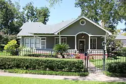 Allbach House |
June 22, 1983 (#83004426) |
2023 Arlington St. 29°48′18″N 95°23′41″W / 29.80489°N 95.39480°W |
Houston | |
| 3 | John W. Anderson House | 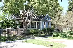 John W. Anderson House |
January 15, 1988 (#87002241) |
711 Columbia 29°47′02″N 95°23′36″W / 29.78390°N 95.39322°W |
Houston | |
| 4 | Banta House | 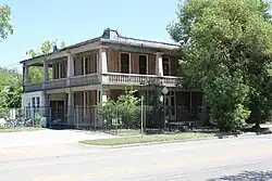 Banta House |
June 22, 1983 (#83004427) |
119 E. 20th St. 29°48′12″N 95°23′50″W / 29.803333°N 95.397222°W |
Houston | |
| 5 | Otto H. Baring House | .jpg.webp) Otto H. Baring House |
January 15, 1988 (#87002242) |
1030 Rutland 29°47′23″N 95°24′02″W / 29.789722°N 95.400556°W |
Houston | |
| 6 | Barker House | 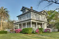 Barker House |
May 14, 1984 (#84001754) |
121 E. 16th St. 29°47′58″N 95°23′49″W / 29.799444°N 95.396944°W |
Houston | |
| 7 | Borgstrom House | .jpg.webp) Borgstrom House |
May 14, 1984 (#84001755) |
1401 Cortlandt St. 29°47′46″N 95°23′44″W / 29.796111°N 95.395556°W |
Houston | |
| 8 | Burge House | .jpg.webp) Burge House |
June 22, 1983 (#83004430) |
1801 Heights Blvd. 29°48′06″N 95°23′54″W / 29.801667°N 95.398333°W |
Houston | |
| 9 | George L. Burlingame House | .jpg.webp) George L. Burlingame House |
January 15, 1988 (#87002243) |
1238 Harvard 29°47′37″N 95°23′45″W / 29.793611°N 95.395833°W |
Houston | |
| 10 | Burnett House | 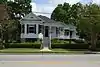 Burnett House |
August 20, 2004 (#83004671) |
219 W. Eleventh St. 29°47′27″N 95°23′59″W / 29.790969°N 95.399851°W |
Houston | |
| 11 | David A. Carden House | 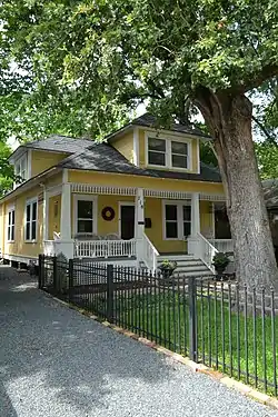 David A. Carden House |
July 17, 1990 (#90001048) |
718 W. 17th Ave. 29°48′02″N 95°24′39″W / 29.800476°N 95.410844°W |
Houston | |
| 12 | Moses A. Clanton House | 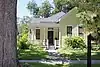 Moses A. Clanton House |
July 17, 1990 (#90001040) |
1025 Arlington 29°47′23″N 95°23′39″W / 29.789722°N 95.394167°W |
Houston | |
| 13 | J. H. Clare House | January 15, 1988 (#87002244) |
939 Arlington 29°47′18″N 95°23′40″W / 29.788462°N 95.394395°W |
Houston | ||
| 14 | Austin Copeland House I | January 15, 1988 (#87002248) |
921 Arlington 29°47′15″N 95°23′39″W / 29.7875°N 95.394167°W |
Houston | ||
| 15 | Austin Copeland House II | January 15, 1988 (#87002245) |
925 Arlington 29°47′16″N 95°23′39″W / 29.787778°N 95.394167°W |
Houston | ||
| 16 | Charles E. Coombs House |  Charles E. Coombs House |
July 17, 1990 (#90001041) |
1037 Columbia 29°47′25″N 95°23′36″W / 29.790164°N 95.393334°W |
Houston | |
| 17 | Dr. B. F. Coop House |  Dr. B. F. Coop House |
May 14, 1984 (#84001757) |
1536 Heights Blvd. 29°47′56″N 95°23′51″W / 29.798889°N 95.3975°W |
Houston | |
| 18 | Countryman House | June 22, 1983 (#83004431) |
402 E. 9th St. 29°47′13″N 95°23′38″W / 29.786832°N 95.393914°W |
Houston | ||
| 19 | Cummings House |  Cummings House |
June 22, 1983 (#83004432) |
1418 Heights Blvd. 29°47′47″N 95°23′51″W / 29.796389°N 95.3975°W |
Houston | |
| 20 | Dexter House | May 14, 1984 (#84001761) |
224 W. 17th St. 29°48′02″N 95°23′59″W / 29.800556°N 95.399722°W |
Houston | Demolished. | |
| 21 | Lula J. Doughty House | .jpg.webp) Lula J. Doughty House |
July 17, 1990 (#90001046) |
1233 Yale St. 29°47′35″N 95°23′57″W / 29.793056°N 95.399167°W |
Houston | |
| 22 | Jay L. Durham House | .jpg.webp) Jay L. Durham House |
January 15, 1988 (#87002246) |
921 Heights Blvd. 29°47′17″N 95°23′11″W / 29.788056°N 95.386389°W |
Houston | |
| 23 | Eaton House | .jpg.webp) Eaton House |
June 22, 1983 (#83004433) |
510 Harvard St. 29°46′47″N 95°23′45″W / 29.779722°N 95.395833°W |
Houston | |
| 24 | Elkins House | June 22, 1983 (#83004434) |
602 E. 9th St. 29°47′13″N 95°23′30″W / 29.786871°N 95.391737°W |
Houston | ||
| 25 | Dr. Billie V. Ellis House | .jpg.webp) Dr. Billie V. Ellis House |
June 22, 1983 (#83004435) |
1515 Heights Blvd. 29°47′54″N 95°23′54″W / 29.798333°N 95.398333°W |
Houston | |
| 26 | Ezzell House | .jpg.webp) Ezzell House |
May 14, 1984 (#84001762) |
1236 Rutland St. 29°47′37″N 95°24′03″W / 29.793611°N 95.400833°W |
Houston | |
| 27 | William F. Fluegel House |  William F. Fluegel House |
January 15, 1988 (#87002247) |
1327 Ashland 29°47′45″N 95°24′13″W / 29.795704°N 95.403709°W |
Houston | Significantly altered and expanded since initial listing. |
| 28 | Gerloff House |  Gerloff House |
July 17, 1990 (#90001047) |
221 E. 12th Ave. 29°47′34″N 95°23′45″W / 29.792766°N 95.395827°W |
Houston | |
| 29 | Gillette House | .jpg.webp) Gillette House |
May 14, 1984 (#84001764) |
301–303 E. 15th St. 29°47′52″N 95°23′43″W / 29.797778°N 95.395278°W |
Houston | |
| 30 | Hartley House |  Hartley House |
June 22, 1983 (#83004437) |
315 W. 17th St. 29°48′04″N 95°24′08″W / 29.801129°N 95.402184°W |
Houston | |
| 31 | Hawkins House | _HDR.jpg.webp) Hawkins House |
May 14, 1984 (#84001765) |
1015 Heights Blvd. 29°47′22″N 95°23′53″W / 29.789444°N 95.398056°W |
Houston | |
| 32 | Heights Boulevard Esplanade | .jpg.webp) Heights Boulevard Esplanade |
May 14, 1984 (#84001766) |
Heights Boulevard from White Oak Bayou to 20th St. 29°46′10″N 95°23′50″W / 29.769444°N 95.397222°W |
Houston | |
| 33 | Heights Christian Church | .jpg.webp) Heights Christian Church |
June 22, 1983 (#83004438) |
1703 Heights Blvd. 29°48′03″N 95°23′54″W / 29.800833°N 95.398333°W |
Houston | |
| 34 | Heights Theater |  Heights Theater |
July 24, 2017 (#100001375) |
339 W. 19th St. 29°48′11″N 95°24′10″W / 29.803145°N 95.402872°W |
Houston | |
| 35 | House at 112 W. 4th Street | .jpg.webp) House at 112 W. 4th Street |
May 14, 1984 (#84001771) |
112 W. 4th St. 29°46′40″N 95°23′52″W / 29.777778°N 95.397778°W |
Houston | |
| 36 | House at 122 East Fifth Street | .jpg.webp) House at 122 East Fifth Street |
May 14, 1984 (#84001776) |
122 E. 5th St. 29°46′46″N 95°23′47″W / 29.779444°N 95.396389°W |
Houston | |
| 37 | House at 201 W. 15th Street |  House at 201 W. 15th Street |
June 22, 1983 (#83004460) |
201 W. 15th St. 29°47′51″N 95°23′57″W / 29.7975°N 95.399167°W |
Houston | |
| 38 | House at 217 E. 5th Street | .jpg.webp) House at 217 E. 5th Street |
May 14, 1984 (#84001786) |
217 E. 5th St. 29°46′46″N 95°23′44″W / 29.779444°N 95.395556°W |
Houston | |
| 39 | House at 402 E. 11th Street |  House at 402 E. 11th Street |
June 22, 1983 (#83004447) |
402 E. 11th Street 29°47′26″N 95°23′38″W / 29.790541°N 95.394002°W |
Houston | |
| 40 | House at 444 West 24th Street | .jpg.webp) House at 444 West 24th Street |
May 14, 1984 (#84001788) |
444 W. 24th St. 29°48′28″N 95°24′12″W / 29.807778°N 95.403333°W |
Houston | |
| 41 | House at 505 W. 18th Street |  House at 505 W. 18th Street |
May 14, 1984 (#84001791) |
505 W. 18th St. 29°48′07″N 95°24′22″W / 29.8020°N 95.4062°W |
Houston | |
| 42 | House at 532 Harvard Street | June 22, 1983 (#83004448) |
532 Harvard St. 29°46′51″N 95°23′46″W / 29.7808°N 95.3960°W |
Houston | ||
| 43 | House at 828 Heights Boulevard | .jpg.webp) House at 828 Heights Boulevard |
June 22, 1983 (#83004451) |
828 Heights Blvd. 29°47′07″N 95°23′50″W / 29.7853°N 95.3972°W |
Houston | |
| 44 | House at 844 Columbia Street | June 22, 1983 (#83004445) |
844 Columbia St. 29°47′13″N 95°23′34″W / 29.7869°N 95.3928°W |
Houston | ||
| 45 | House at 844 Cortlandt | June 22, 1983 (#83004444) |
844 Cortlandt 29°47′12″N 95°23′42″W / 29.7868°N 95.3950°W |
Houston | ||
| 46 | House at 917 Heights Boulevard | .jpg.webp) House at 917 Heights Boulevard |
May 14, 1984 (#84001793) |
917 Heights Blvd. 29°47′14″N 95°23′53″W / 29.7872°N 95.3981°W |
Houston | |
| 47 | House at 943½ Cortlandt Street | January 7, 1993 (#84003972) |
943½ Cortlandt St. 29°47′19″N 95°23′44″W / 29.7886°N 95.3955°W |
Houston | ||
| 48 | Houses at 1217 and 1219 Tulane Street | December 9, 2020 (#100005898) |
1217 Tulane St. 29°47′36″N 95°24′09″W / 29.7932°N 95.4024°W |
Houston | ||
| 49 | House at 1227 Rutland Street | .jpg.webp) House at 1227 Rutland Street |
May 14, 1984 (#84001777) |
1227 Rutland St. 29°47′35″N 95°24′04″W / 29.7931°N 95.4011°W |
Houston | |
| 50 | House at 1237 Rutland Street | .jpg.webp) House at 1237 Rutland Street |
June 22, 1983 (#83004456) |
1237 Rutland St. 29°47′37″N 95°24′04″W / 29.7936°N 95.4011°W |
Houston | |
| 51 | House at 1111 Heights Boulevard |  House at 1111 Heights Boulevard |
May 14, 1984 (#84001768) |
1111 Heights Blvd. 29°47′28″N 95°23′53″W / 29.7912°N 95.3981°W |
Houston | |
| 52 | House at 1210 Harvard Street | .jpg.webp) House at 1210 Harvard Street |
May 14, 1984 (#84001774) |
1210 Harvard St. 29°47′34″N 95°23′46″W / 29.7928°N 95.3961°W |
Houston | |
| 53 | House at 1217 Harvard | .jpg.webp) House at 1217 Harvard |
January 15, 1988 (#87002249) |
1217 Harvard 29°47′35″N 95°23′48″W / 29.7931°N 95.3967°W |
Houston | |
| 54 | House at 1220 Harvard | .jpg.webp) House at 1220 Harvard |
January 15, 1988 (#87002250) |
1220 Harvard 29°47′35″N 95°23′45″W / 29.7931°N 95.3958°W |
Houston | |
| 55 | House at 1222 Harvard Street | .jpg.webp) House at 1222 Harvard Street |
July 17, 1990 (#90001043) |
1222 Harvard St. 29°47′35″N 95°23′45″W / 29.7931°N 95.3958°W |
Houston | |
| 56 | House at 1230 Oxford Street |  House at 1230 Oxford Street |
May 14, 1984 (#84001780) |
1230 Oxford St. 29°47′37″N 95°23′32″W / 29.7936°N 95.3922°W |
Houston | |
| 57 | House at 1304 Cortlandt Street |  House at 1304 Cortlandt Street |
May 14, 1984 (#84001784) |
1304 Cortlandt St. 29°47′41″N 95°23′42″W / 29.7946°N 95.3951°W |
Houston | |
| 58 | House at 1343 Allston Street |  House at 1343 Allston Street |
June 22, 1983 (#83004443) |
1343 Allston St. 29°47′46″N 95°24′01″W / 29.7960°N 95.4004°W |
Houston | Significantly altered and expanded since initial listing. |
| 59 | House at 1421 Harvard St. | .jpg.webp) House at 1421 Harvard St. |
June 22, 1983 (#83004449) |
1421 Harvard St. 29°47′48″N 95°23′48″W / 29.7967°N 95.3967°W |
Houston | |
| 60 | House at 1421 Heights Boulevard |  House at 1421 Heights Boulevard |
June 22, 1983 (#83004452) |
1421 Heights Blvd. 29°47′49″N 95°23′54″W / 29.7970°N 95.3983°W |
Houston | |
| 61 | House at 1435 Heights Boulevard | .jpg.webp) House at 1435 Heights Boulevard |
January 15, 1988 (#87002251) |
1435 Heights Blvd. 29°47′50″N 95°23′53″W / 29.7972°N 95.3981°W |
Houston | |
| 62 | House at 1437 Waverly Street | .jpg.webp) House at 1437 Waverly Street |
June 22, 1983 (#83004458) |
1437 Waverly St. 29°47′49″N 95°24′16″W / 29.796944°N 95.404444°W |
Houston | |
| 63 | House at 1437 Heights Boulevard | .jpg.webp) House at 1437 Heights Boulevard |
June 22, 1983 (#83004453) |
1437 Heights Blvd. 29°47′50″N 95°23′54″W / 29.797222°N 95.398333°W |
Houston | |
| 64 | House at 1443 Allston Street |  House at 1443 Allston Street |
June 22, 1983 (#83004442) |
1443 Allston St. 29°47′52″N 95°24′02″W / 29.797751°N 95.400441°W |
Houston | |
| 65 | House at 1509 Allston Street |  House at 1509 Allston Street |
June 22, 1983 (#83004441) |
1509 Allston St. 29°47′55″N 95°24′02″W / 29.798486°N 95.400520°W |
Houston | |
| 66 | House at 1515 Allston Street |  House at 1515 Allston Street |
June 22, 1983 (#83004440) |
1515 Allston St. 29°47′55″N 95°24′02″W / 29.798631°N 95.400468°W |
Houston | |
| 67 | House at 1517 Cortland Street | June 22, 1983 (#83004446) |
1517 Cortland St. 29°47′56″N 95°23′45″W / 29.798826°N 95.395767°W |
Houston | ||
| 68 | House at 1537 Tulane Street | .jpg.webp) House at 1537 Tulane Street |
June 22, 1983 (#83004457) |
1537 Tulane Street 29°47′56″N 95°24′08″W / 29.798889°N 95.402222°W |
Houston | |
| 69 | House at 1640 Harvard Street |  House at 1640 Harvard Street |
June 22, 1983 (#83004450) |
1640 Harvard St. 29°48′05″N 95°23′47″W / 29.801511°N 95.396361°W |
Houston | House modified and expanded significantly since initial listing. |
| 70 | House at 2035 Rutland Street |  House at 2035 Rutland Street |
June 22, 1983 (#83004455) |
2035 Rutland St. 29°48′17″N 95°24′06″W / 29.804722°N 95.401722°W |
Houston | |
| 71 | House at 1421–1423 Waverly Street |  House at 1421–1423 Waverly Street |
June 22, 1983 (#83004459) |
1421–1423 Waverly St. 29°47′47″N 95°24′16″W / 29.796389°N 95.404444°W |
Houston | |
| 72 | House at 2402 Rutland Street | 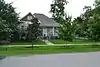 House at 2402 Rutland Street |
June 22, 1983 (#83004454) |
2402 Rutland St. 29°48′29″N 95°24′05″W / 29.808161°N 95.401298°W |
Houston | |
| 73 | Houston Public Library | 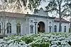 Houston Public Library |
May 14, 1984 (#84001795) |
1302 Heights Blvd. 29°47′39″N 95°23′51″W / 29.794167°N 95.3975°W |
Houston | |
| 74 | Houston Heights Fire Station | .jpg.webp) Houston Heights Fire Station |
June 22, 1983 (#83004461) |
Yale and 12th Sts. 29°47′33″N 95°23′56″W / 29.7925°N 95.398889°W |
Houston | |
| 75 | Houston Heights Waterworks Reservoir | .jpg.webp) Houston Heights Waterworks Reservoir |
June 22, 1983 (#83004462) |
W. 20 and Nicolson Sts. 29°48′15″N 95°24′23″W / 29.804167°N 95.406389°W |
Houston | |
| 76 | Houston Heights Woman's Club | 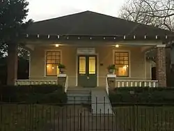 Houston Heights Woman's Club |
June 22, 1983 (#83004463) |
1846 Harvard St 29°48′13″N 95°23′47″W / 29.803677°N 95.396438°W |
Houston | |
| 77 | Immanuel Lutheran Church | 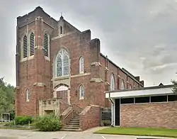 Immanuel Lutheran Church |
June 22, 1983 (#83004464) |
1448 Cortlandt St. 29°47′52″N 95°23′42″W / 29.797778°N 95.395°W |
Houston | |
| 78 | Isbell House | .jpg.webp) Isbell House |
June 22, 1983 (#83004465) |
639 Heights Blvd. 29°46′56″N 95°23′52″W / 29.782222°N 95.397778°W |
Houston | |
| 79 | James L. Jensen House | July 17, 1990 (#90001039) |
721 Arlington 29°47′03″N 95°23′39″W / 29.784085°N 95.394260°W |
Houston | ||
| 80 | Jones House | June 22, 1983 (#83004466) |
1115–1117 Allston St. 29°47′29″N 95°24′02″W / 29.791433°N 95.400447°W |
Houston | ||
| 81 | Keller House |  Keller House |
May 14, 1984 (#84001797) |
1448 Heights Blvd. 29°47′51″N 95°23′51″W / 29.7975°N 95.3975°W |
Houston | |
| 82 | Marshall W. Kennedy House | .jpg.webp) Marshall W. Kennedy House |
January 15, 1988 (#87002252) |
1122 Harvard 29°47′28″N 95°23′45″W / 29.791111°N 95.395833°W |
Houston | |
| 83 | Kleinhaus House | June 22, 1983 (#83004467) |
803 Yale St. 29°47′07″N 95°23′57″W / 29.785355°N 95.399132°W |
Houston | ||
| 84 | Knittel House | .jpg.webp) Knittel House |
June 22, 1983 (#83004468) |
1601 Ashland St. 29°47′59″N 95°24′10″W / 29.799722°N 95.402778°W |
Houston | |
| 85 | Kronenberger House | .jpg.webp) Kronenberger House |
June 22, 1983 (#83004469) |
612 W. 26th St. 29°48′34″N 95°24′18″W / 29.809444°N 95.405°W |
Houston | |
| 86 | Emil Lindenburg House | .jpg.webp) Emil Lindenburg House |
January 15, 1988 (#87002253) |
1445 Harvard 29°47′52″N 95°23′48″W / 29.797778°N 95.396667°W |
Houston | |
| 87 | Fayette C. Lowry House |  Fayette C. Lowry House |
July 19, 1990 (#90001045) |
2009 Harvard 29°48′16″N 95°23′49″W / 29.804580°N 95.396945°W |
Houston | |
| 88 | Lund House |  Lund House |
June 22, 1983 (#83004470) |
301 E. 5th St. 29°46′46″N 95°23′42″W / 29.779444°N 95.395°W |
Houston | |
| 89 | Mansfield House | .jpg.webp) Mansfield House |
June 22, 1983 (#83004472) |
1802 Harvard St. 29°48′06″N 95°23′47″W / 29.801667°N 95.396389°W |
Houston | |
| 90 | Henry Hicks McCain House | January 15, 1988 (#87002254) |
1026 Allston 29°47′23″N 95°23′59″W / 29.789852°N 95.399845°W |
Houston | ||
| 91 | D. C. McCollum House | .jpg.webp) D. C. McCollum House |
July 17, 1990 (#90001049) |
433 W. 24th St. 29°48′29″N 95°24′16″W / 29.808056°N 95.404444°W |
Houston | |
| 92 | McDonald House | June 22, 1983 (#83004473) |
1801 Ashland St. 29°48′06″N 95°24′10″W / 29.801667°N 95.402778°W |
Houston | Demolished[5] | |
| 93 | Meitzen House | May 14, 1984 (#84001813) |
725 Harvard St. 29°47′04″N 95°23′48″W / 29.784331°N 95.396536°W |
Houston | ||
| 94 | Miller House | .jpg.webp) Miller House |
May 14, 1984 (#84001814) |
1245 Yale St. 29°47′37″N 95°23′57″W / 29.793611°N 95.399167°W |
Houston | |
| 95 | John Milroy House |  John Milroy House |
November 12, 1980 (#80004131) |
1102 Heights Blvd. 29°47′28″N 95°23′50″W / 29.790997°N 95.397269°W |
Houston | Second duplicate listing approved in 1983 (#83004474). |
| 96 | Milroy-Muller House |  Milroy-Muller House |
May 14, 1984 (#84001816) |
1602 Harvard St. 29°47′59″N 95°23′46″W / 29.799722°N 95.396111°W |
Houston | |
| 97 | Glenn W. Morris House |  Glenn W. Morris House |
July 17, 1990 (#90001044) |
1611 Harvard St. 29°48′01″N 95°23′49″W / 29.800414°N 95.396824°W |
Houston | |
| 98 | Morton Brothers Grocery | .jpg.webp) Morton Brothers Grocery |
January 15, 1988 (#87002255) |
401 W. Ninth 29°47′13″N 95°24′04″W / 29.786944°N 95.401111°W |
Houston | |
| 99 | Mulcahy House |  Mulcahy House |
May 14, 1984 (#84001819) |
1046 Harvard St. 29°47′26″N 95°23′46″W / 29.790514°N 95.396188°W |
Houston | |
| 100 | Forrest A. Nairn House |  Forrest A. Nairn House |
November 12, 1991 (#87002256) |
1148 Heights Blvd. 29°47′33″N 95°23′51″W / 29.792404°N 95.397388°W |
Houston | |
| 101 | Joseph Ogle House | June 22, 1983 (#83004475) |
530 Harvard St. 29°46′50″N 95°23′46″W / 29.780639°N 95.395985°W |
Houston | ||
| 102 | Oriental Textile Mill | .jpg.webp) Oriental Textile Mill |
June 22, 1983 (#83004476) |
2201 Lawrence St. 29°48′22″N 95°24′30″W / 29.806083°N 95.408472°W |
Houston | |
| 103 | Otto House | .jpg.webp) Otto House |
May 14, 1984 (#84001820) |
835 Rutland St. 29°47′09″N 95°24′03″W / 29.785833°N 95.400833°W |
Houston | |
| 104 | Perry-Swilley House | 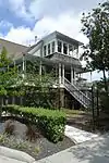 Perry-Swilley House |
June 22, 1983 (#83004477) |
1101 Heights Blvd. 29°47′28″N 95°23′53″W / 29.791075°N 95.398054°W |
Houston | |
| 105 | Thomas B. Reed House | .jpg.webp) Thomas B. Reed House |
July 17, 1990 (#90001038) |
933 Allston St. 29°47′17″N 95°24′01″W / 29.788056°N 95.400278°W |
Houston | |
| 106 | Charles Roessler House | January 15, 1988 (#87002257) |
736 Cortland 29°47′05″N 95°23′42″W / 29.784641°N 95.394922°W |
Houston | ||
| 107 | Ghent W. Rogers House | 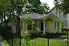 Ghent W. Rogers House |
July 17, 1990 (#90001042) |
1150 Cortlandt 29°47′33″N 95°23′42″W / 29.792419°N 95.395129°W |
Houston | |
| 108 | St. Mark's Methodist Church | July 7, 2022 (#100007914) |
600 Pecore St. 29°47′26″N 95°22′40″W / 29.7905°N 95.3778°W |
Houston | ||
| 109 | Schlesser-Burrows House | 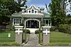 Schlesser-Burrows House |
May 14, 1984 (#84001823) |
1123 Harvard St. 29°47′30″N 95°23′48″W / 29.791547°N 95.396682°W |
Houston | |
| 110 | John H. Shoaf House | 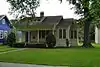 John H. Shoaf House |
January 15, 1988 (#87002258) |
2030 Arlington 29°48′19″N 95°23′39″W / 29.805169°N 95.394210°W |
Houston | |
| 111 | Dr. Penn B. Thornton House | .jpg.webp) Dr. Penn B. Thornton House |
June 22, 1983 (#83004480) |
1541 Tulane St. 29°47′57″N 95°24′08″W / 29.799167°N 95.402222°W |
Houston | |
| 112 | Upchurch House | .jpg.webp) Upchurch House |
June 22, 1983 (#83004482) |
301 E. 14th St. 29°47′45″N 95°23′43″W / 29.795833°N 95.395278°W |
Houston | |
| 113 | Ward House |  Ward House |
June 22, 1983 (#83004483) |
323 W. 17th St. 29°48′01″N 95°24′04″W / 29.800278°N 95.401111°W |
Houston | |
| 114 | Webber House | .JPG.webp) Webber House |
May 14, 1984 (#84001829) |
1011 Heights Blvd. 29°47′26″N 95°23′53″W / 29.790556°N 95.398056°W |
Houston | |
| 115 | Samuel H. Webber House | June 22, 1983 (#83004484) |
407 Heights Blvd. 29°46′42″N 95°23′52″W / 29.778249°N 95.397839°W |
Houston | ||
| 116 | Wilkins House | .jpg.webp) Wilkins House |
May 14, 1984 (#84001831) |
1541 Ashland St. 29°47′57″N 95°24′12″W / 29.799167°N 95.403333°W |
Houston | |
| 117 | Williams-Brueder House |  Williams-Brueder House |
June 22, 1983 (#83004485) |
245 W. 18th St. 29°48′08″N 95°24′04″W / 29.802129°N 95.401147°W |
Houston | |
| 118 | Wilson House |  Wilson House |
May 14, 1984 (#84001841) |
1206 Cortlandt St. 29°47′34″N 95°23′42″W / 29.792785°N 95.395118°W |
Houston | |
| 119 | Wimberly House |  Wimberly House |
May 14, 1984 (#84001843) |
703 Harvard St. 29°46′28″N 95°23′46″W / 29.774444°N 95.396111°W |
Houston | |
| 120 | Wisnoski House |  Wisnoski House |
May 14, 1984 (#84001844) |
1651 Columbia St. 29°47′59″N 95°23′36″W / 29.799722°N 95.393333°W |
Houston | |
| 121 | Woodard House | .jpg.webp) Woodard House |
May 14, 1984 (#84001847) |
740 Rutland St. 29°47′04″N 95°24′02″W / 29.784444°N 95.400556°W |
Houston | |
| 122 | Woodward House |  Woodward House |
June 22, 1983 (#83004486) |
1605 Heights Blvd. 29°48′01″N 95°23′54″W / 29.800401°N 95.398304°W |
Houston | |
| 123 | Yale Street Bridge over White Oak Bayou |  Yale Street Bridge over White Oak Bayou |
December 30, 2011 (#11000981) |
Yale St. at White Oak Bayou 29°46′32″N 95°23′55″W / 29.77553°N 95.3987°W |
Houston |
Former listings
| [3] | Name on the Register | Image | Date listed | Date removed | Location | City or town | Description |
|---|---|---|---|---|---|---|---|
| 1 | Building at 430 Harvard Street | June 22, 1983 (#83004429) | October 22, 1992 | 430 Harvard St. 29°46′44″N 95°23′45″W / 29.778960°N 95.395944°W |
Houston | Also known as the Heights Telephone Company Building. Demolished in 1992. | |
| 2 | Schauer Filling Station | June 22, 1983 (#83004478) | June 14, 2017 | 1400 Oxford St. 29°47′46″N 95°23′32″W / 29.796111°N 95.392222°W |
Houston | Demolished in June, 2013.[6][7] |
References
- ↑ The latitude and longitude information provided in this table was derived originally from the National Register Information System, which has been found to be fairly accurate for about 99% of listings. Some locations in this table may have been corrected to current GPS standards.
- ↑ National Park Service, United States Department of the Interior, "National Register of Historic Places: Weekly List Actions", retrieved January 12, 2024.
- 1 2 Numbers represent an alphabetical ordering by significant words. Various colorings, defined here, differentiate National Historic Landmarks and historic districts from other NRHP buildings, structures, sites or objects.
- ↑ The eight-digit number below each date is the number assigned to each location in the National Register Information System database, which can be viewed by clicking the number.
- ↑ Allison Wollam (26 February 2006). "Ashland House demolition tees off preservationists". Houston Business Journal. Retrieved 25 April 2023. (subscription required)
- ↑ "Another historic building dozed: Heights landmark disappears over the weekend". Culture Map Houston. 2 July 2013.
- ↑ "The End for the Historic Heights Schauer Filling Station?". Swamplot. 28 June 2013.
External links
| Topics | |
|---|---|
| Lists by state |
|
| Lists by insular areas | |
| Lists by associated state | |
| Other areas | |
| Related | |
This article is issued from Wikipedia. The text is licensed under Creative Commons - Attribution - Sharealike. Additional terms may apply for the media files.