
Location of DeSoto County in Florida
This is a detailed table of the district on the National Register of Historic Places in DeSoto County, Florida, United States. The location of the National Register district for which the latitude and longitude coordinates are included below, may be seen in a map.[1]
There are 5 listings on the National Register in the county.
This National Park Service list is complete through NPS recent listings posted January 12, 2024.[2]
| Alachua - Baker - Bay - Bradford - Brevard - Broward - Calhoun - Charlotte - Citrus - Clay - Collier - Columbia - DeSoto - Dixie - Duval - Escambia - Flagler - Franklin - Gadsden - Gilchrist - Glades - Gulf - Hamilton - Hardee - Hendry - Hernando - Highlands - Hillsborough (Tampa) - Holmes - Indian River - Jackson - Jefferson - Lafayette - Lake - Lee - Leon - Levy - Liberty - Madison - Manatee - Marion - Martin - Miami-Dade (Miami) - Monroe - Nassau - Okaloosa - Okeechobee - Orange - Osceola - Palm Beach - Pasco - Pinellas - Polk - Putnam - St. Johns - St. Lucie - Santa Rosa - Sarasota - Seminole - Sumter - Suwannee - Taylor - Union - Volusia - Wakulla - Walton - Washington |
Current listing
| [3] | Name on the Register[4] | Image | Date listed[5] | Location | City or town | Description |
|---|---|---|---|---|---|---|
| 1 | Arcadia Historic District | 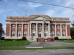 Arcadia Historic District |
May 10, 1984 (#84000842) |
Roughly bounded by Lee and Miles Avenues and Imogene, Cypress, Pine, and Magnolia Streets 27°12′57″N 81°51′37″W / 27.215833°N 81.860278°W |
Arcadia | |
| 2 | Johnson-Smith House | 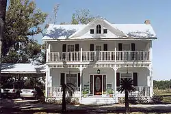 Johnson-Smith House |
April 16, 2013 (#13000163) |
1519 N. Arcadia Ave. 27°14′10″N 81°51′29″W / 27.236199°N 81.857989°W |
Arcadia | |
| 3 | Pine Level Archeological District | 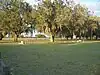 Pine Level Archeological District |
September 17, 2014 (#14000618) |
Address Restricted 27°16′00″N 82°00′00″W / 27.266667°N 82°W |
Arcadia | |
| 4 | William Oswell Ralls House | 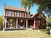 William Oswell Ralls House |
February 14, 2011 (#11000001) |
640 West Whidden Street 27°13′13″N 81°52′01″W / 27.220278°N 81.866944°W |
Arcadia | |
| 5 | Micajah T. Singleton House | 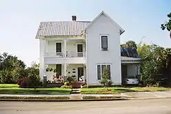 Micajah T. Singleton House |
August 6, 2013 (#13000578) |
711 West Hickory Street 27°13′11″N 81°52′08″W / 27.2195853°N 81.8689501°W |
Arcadia |
See also
Wikimedia Commons has media related to National Register of Historic Places in DeSoto County, Florida.
References
- ↑ The latitude and longitude information provided in this table was derived originally from the National Register Information System, which has been found to be fairly accurate for about 99% of listings. Some locations in this table may have been corrected to current GPS standards.
- ↑ National Park Service, United States Department of the Interior, "National Register of Historic Places: Weekly List Actions", retrieved January 12, 2024.
- ↑ Numbers represent an alphabetical ordering by significant words. Various colorings, defined here, differentiate National Historic Landmarks and historic districts from other NRHP buildings, structures, sites or objects.
- ↑ "National Register Information System". National Register of Historic Places. National Park Service. March 13, 2009.
- ↑ The eight-digit number below each date is the number assigned to each location in the National Register Information System database, which can be viewed by clicking the number.

Municipalities and communities of DeSoto County, Florida, United States | ||
|---|---|---|
| City | | |
| CDP | ||
| Unincorporated communities | ||
| Ghost towns | ||
This article is issued from Wikipedia. The text is licensed under Creative Commons - Attribution - Sharealike. Additional terms may apply for the media files.