Nain County
Persian: شهرستان نائین | |
|---|---|
County | |
 Location of Nain County in Isfahan province (right, green) | |
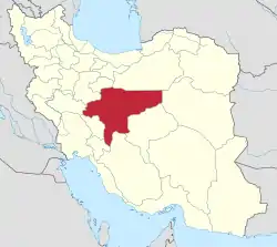 Location of Isfahan province in Iran | |
| Coordinates: 33°22′N 53°29′E / 33.367°N 53.483°E[1] | |
| Country | |
| Province | Isfahan |
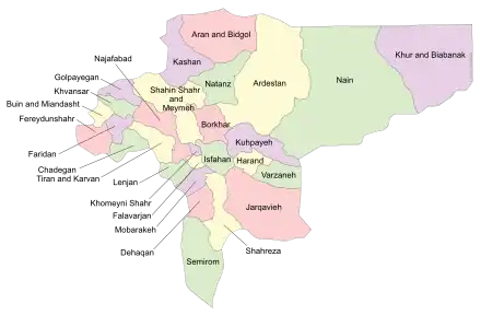
| Capital | Nain |
| Districts | Central, Anarak |
| Population (2016)[2] | |
| • Total | 39,261 |
| Time zone | UTC+3:30 (IRST) |
Nain County (Persian: شهرستان نائین) is in Isfahan province, Iran. Its capital is the city of Nain.
At the 2006 census, the county's population was 54,298 in 15,919 households.[3] The following census in 2011 counted 38,077 people in 12,123 households,[4] by which time Khur and Biabanak District had been separated from the county in he establishment of Khur and Biabanak County.[5] At the 2016 census, the county's population was 39,261 in 13,378 households.[2]
Administrative divisions
The population history and structural changes of Nain County's administrative divisions over three consecutive censuses are shown in the following table. The latest census shows two districts, five rural districts, and three cities.[2]
| Administrative Divisions | 2006[3] | 2011[4] | 2016[2] |
|---|---|---|---|
| Central District | 33,906 | 34,177 | 35,440 |
| Bafran RD | 3,603 | 1,782 | 1,483 |
| Baharestan RD | 1,603 | 1,444 | 1,302 |
| Kuhestan RD | 1,735 | 992 | 996 |
| Lay Siyah RD | 2,541 | 2,553 | 2,302 |
| Bafran (city) | 2,027 | 1,978 | |
| Nain (city) | 24,424 | 25,379 | 27,379 |
| Anarak District | 2,904 | 3,900 | 3,820 |
| Chupanan RD | 1,619 | 2,423 | 1,917 |
| Anarak (city) | 1,285 | 1,477 | 1,903 |
| Khur and Biabanak District1 | 17,488 | ||
| Biabanak RD | 4,710 | ||
| Jandaq RD | 208 | ||
| Nakhlestan RD | 2,396 | ||
| Jandaq (city) | 3,958 | ||
| Khur (city) | 6,216 | ||
| Total | 54,298 | 38,077 | 39,261 |
| RD: Rural District 1Became a part of Khur and Biabanak County[5] | |||
Wikimedia Commons has media related to Nain County.
References
- ↑ OpenStreetMap contributors (20 June 2023). "Nain County" (Map). OpenStreetMap. Retrieved 20 June 2023.
- 1 2 3 4 "Census of the Islamic Republic of Iran, 1395 (2016)". AMAR (in Persian). The Statistical Center of Iran. p. 10. Archived from the original (Excel) on 19 October 2020. Retrieved 19 December 2022.
- 1 2 "Census of the Islamic Republic of Iran, 1385 (2006)". AMAR (in Persian). The Statistical Center of Iran. p. 10. Archived from the original (Excel) on 20 September 2011. Retrieved 25 September 2022.
- 1 2 "Census of the Islamic Republic of Iran, 1390 (2011)" (Excel). Iran Data Portal (in Persian). The Statistical Center of Iran. p. 10. Retrieved 19 December 2022.
- 1 2 Ahmadinejad, Mahmoud (1 August 2009). "Khur and Biabanak County was added to the map of country divisions". Minister of Interior (in Persian). Ministry of Interior, Council of Ministers. Archived from the original on 4 March 2016. Retrieved 21 November 2023.

| Capital | |||||||||||||||||||||||
|---|---|---|---|---|---|---|---|---|---|---|---|---|---|---|---|---|---|---|---|---|---|---|---|
| Districts |
| ||||||||||||||||||||||
This article is issued from Wikipedia. The text is licensed under Creative Commons - Attribution - Sharealike. Additional terms may apply for the media files.