Mykines
Μυκήνες | |
|---|---|
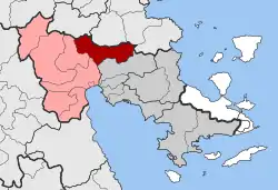
 Mykines Location within the regional unit  | |
| Coordinates: 37°43′N 22°45′E / 37.717°N 22.750°E | |
| Country | Greece |
| Administrative region | Peloponnese |
| Regional unit | Argolis |
| Municipality | Argos-Mykines |
| • Municipal unit | 159.0 km2 (61.4 sq mi) |
| Elevation | 75 m (246 ft) |
| Population (2011)[1] | |
| • Municipal unit | 3,388 |
| • Municipal unit density | 21/km2 (55/sq mi) |
| Community | |
| • Population | 354 (2011) |
| Time zone | UTC+2 (EET) |
| • Summer (DST) | UTC+3 (EEST) |
| Postal code | 212 00 |
| Area code(s) | 27510 |
| Vehicle registration | AP |
Mykines (Greek: Μυκήνες), known before 1916 as Charvati (Χαρβάτι),[2] is a village and a former municipality in Argolis, Peloponnese, Greece. Since the 2011 local government reform it is part of the municipality Argos-Mykines, of which it is a municipal unit.[3] The municipal unit has an area of 159.033 km2.[4] It is located 1 km west of the ancient site of Mycenae and 2 km east of the highway linking Argos and Corinth. It is 9 km north of Argos.
Name
The name Mykines is the modern Greek version of Mycenae. The village is near the archaeological site of Mycenae.
Historical population
Mykines was historically an Arvanite town.[5]
| Year | Community | Municipal unit |
|---|---|---|
| 1981 | 440 | - |
| 1991 | 436 | 4,412 |
| 2001 | 422 | 4,349 |
| 2011 | 354 | 3,388 |
References
- 1 2 "Απογραφή Πληθυσμού - Κατοικιών 2011. ΜΟΝΙΜΟΣ Πληθυσμός" (in Greek). Hellenic Statistical Authority.
- ↑ Name changes of settlements in Greece
- ↑ "ΦΕΚ B 1292/2010, Kallikratis reform municipalities" (in Greek). Government Gazette.
- ↑ "Population & housing census 2001 (incl. area and average elevation)" (PDF) (in Greek). National Statistical Service of Greece.
- ↑ Zervas, Theodore. "Learning Arvanitic in Late 19th and Early 20th Century Greece: Linguistic Maintenance and Cultural Idiosyncrasies in Greece’s Arvanitic Speaking Communities." Zeitschrift für Balkanologie 50.2 (2014). page
This article is issued from Wikipedia. The text is licensed under Creative Commons - Attribution - Sharealike. Additional terms may apply for the media files.