Musaili
मुसैली | |
|---|---|
Village | |
 Musaili Location in Nepal | |
| Coordinates: 26°51′27″N 85°32′16″E / 26.85750°N 85.53778°E | |
| Country | |
| Zone | Janakpur Zone |
| District | Sarlahi District |
| Rural Municipality | Kaudena Rural Municipality |
| Population (2011) | |
| • Total | 5,190 |
| Time zone | UTC+5:45 (Nepal Time) |
Musauli or Musaili (Nepali: मुसैली, Maithili: मुसैली) is a village and former village development committee (VDC) in Sarlahi District in the Janakpur Zone of south-eastern Nepal. It is about 2 kilometres (1.2 mi) west of the district town of Malangwa and about 2 kilometres (1.2 mi) north of the border with India.[1] At the time of the 1991 Nepal census the former VDC had a population of 4,195 individuals, [2] and in 2011, 5190 people were reported.[3]
Landmarks
The village contains the Musauli Masjid and Baudhi Mai mosques and Shree Baudhi Devi secondary school.[1]
Economy
There is a meat factory and distillery to the west of the village, along the road to Kaudena.[1] The provincial government has allocated 80 million rupees to maintain the pond, given that it is a tourist attraction.[4]
References
- 1 2 3 Google (29 April 2023). "Musauli" (Map). Google Maps. Google. Retrieved 29 April 2023.
- ↑ "Nepal Census 2001". Nepal's Village Development Committees. Digital Himalaya. Retrieved 2 November 2008.
- ↑ "Sarlahi VDC Level Report" (PDF). censusnepal.cbs.gov.np. Retrieved 2 May 2023.
- ↑ "प्रदेश सांसद् यादवद्वारा मुसैली पोखरी सौन्दर्यकरण कार्यक्रमको अुनगमन" (in Nepali). Ujyaaloabhiyan.com. Retrieved 29 April 2023.
Headquarter: Malangwa | ||
| Municipalities: 11 | 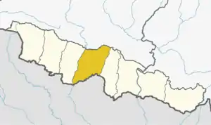 | |
| Rural Municipalities: 9 | ||