Muran District
Persian: بخش موران | |
|---|---|
 Muran District | |
| Coordinates: 39°04′32″N 48°15′21″E / 39.07556°N 48.25583°E[1] | |
| Country | |
| Province | Ardabil |
| County | Germi |
| Capital | Zahra |
| Population (2016)[2] | |
| • Total | 10,019 |
| Time zone | UTC+3:30 (IRST) |
Muran District (Persian: بخش موران) is in Germi County, Ardabil province, Iran. Its capital is the village of Zahra.[3]
At the 2006 census, its population was 12,964 in 2,556 households.[4] The following census in 2011 counted 11,124 people in 2,723 households.[5] At the latest census in 2016, the district had 10,019 inhabitants living in 2,931 households.[2]
| Administrative Divisions | 2006[4] | 2011[5] | 2016[2] |
|---|---|---|---|
| Azadlu RD | 4,720 | 4,197 | 3,855 |
| Ojarud-e Sharqi RD | 8,244 | 6,927 | 6,164 |
| Total | 12,964 | 11,124 | 10,019 |
| RD: Rural District | |||
References
- ↑ OpenStreetMap contributors (27 March 2023). "Muran District (Germi County)" (Map). OpenStreetMap. Retrieved 27 March 2023.
- 1 2 3 "Census of the Islamic Republic of Iran, 1395 (2016)". AMAR (in Persian). The Statistical Center of Iran. p. 24. Archived from the original (Excel) on 22 March 2019. Retrieved 19 December 2022.
- ↑ Aref, Mohammad Reza. "Approval letter regarding division reforms in Ardabil province". Islamic Parliament Research Center (in Persian). Ministry of Interior, Board of Ministers. Archived from the original on 10 February 2011. Retrieved 27 November 2023.
- 1 2 "Census of the Islamic Republic of Iran, 1385 (2006)". AMAR (in Persian). The Statistical Center of Iran. p. 24. Archived from the original (Excel) on 20 September 2011. Retrieved 25 September 2022.
- 1 2 "Census of the Islamic Republic of Iran, 1390 (2011)". Syracuse University (in Persian). The Statistical Center of Iran. p. 24. Archived from the original (Excel) on 15 January 2023. Retrieved 19 December 2022.
| Capital | 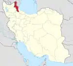 | ||||||||||||||||||||||
|---|---|---|---|---|---|---|---|---|---|---|---|---|---|---|---|---|---|---|---|---|---|---|---|
| Counties and cities |
| ||||||||||||||||||||||
| Landmarks |
| ||||||||||||||||||||||
| Places | |||||||||||||||||||||||
This article is issued from Wikipedia. The text is licensed under Creative Commons - Attribution - Sharealike. Additional terms may apply for the media files.