Municipality of Gornja Radgona
Občina Gornja Radgona | |
|---|---|
 | |
 Coat of arms | |
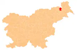
 Location of the Municipality of Gornja Radgona in Slovenia | |
| Coordinates: 46°40′N 15°59′E / 46.67°N 15.98°E | |
| Country | |
| Government | |
| • Mayor | Urška Mauko Tuš |
| Area | |
| • Total | 75 km2 (29 sq mi) |
| Population (2012)[1] | |
| • Total | 8,617 |
| • Density | 110/km2 (300/sq mi) |
| Time zone | UTC+01 (CET) |
| • Summer (DST) | UTC+02 (CEST) |
| Website | www |
The Municipality of Gornja Radgona (pronounced [ˈɡoːɾnja ˈɾaːdɡɔna] ⓘ; Slovene: Občina Gornja Radgona) a municipality in Slovenia. The seat of the municipality is the town of Gornja Radgona.[2]
Settlements
In addition to the municipal seat of Gornja Radgona, the municipality also includes the following settlements:
- Aženski Vrh
- Črešnjevci
- Gornji Ivanjci
- Hercegovščak
- Ivanjski Vrh
- Ivanjševci ob Ščavnici
- Ivanjševski Vrh
- Kunova
- Lastomerci
- Lokavci
- Lomanoše
- Mele
- Negova
- Norički Vrh
- Očeslavci
- Orehovci
- Orehovski Vrh
- Plitvički Vrh
- Podgrad
- Police
- Ptujska Cesta
- Radvenci
- Rodmošci
- Spodnja Ščavnica
- Spodnji Ivanjci
- Stavešinci
- Stavešinski Vrh
- Zagajski Vrh
- Zbigovci
References
External links
 Media related to Municipality of Gornja Radgona at Wikimedia Commons
- Municipality of Gornja Radgona on Geopedia
- Gornja Radgona municipal site
This article is issued from Wikipedia. The text is licensed under Creative Commons - Attribution - Sharealike. Additional terms may apply for the media files.
