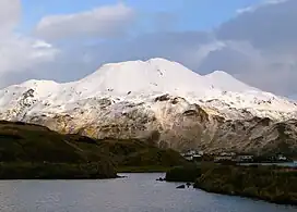
| Mount Newhall | |
|---|---|
 West aspect | |
| Highest point | |
| Elevation | 1,916 ft (584 m)[1] |
| Prominence | 1,166 ft (355 m)[1] |
| Parent peak | Peak 2353[1] |
| Isolation | 2.67 mi (4.30 km)[1] |
| Coordinates | 53°52′23″N 166°29′01″W / 53.8730556°N 166.4836111°W[2] |
| Naming | |
| Etymology | Dr. A. W. Newhall |
| Geography | |
 Mount Newhall Location in Alaska | |
| Location | Aleutians West Census Area[2] |
| Country | United States |
| State | Alaska |
| Protected area | Alaska Maritime National Wildlife Refuge |
| Parent range | Aleutian Range[3] |
| Topo map | USGS Unalaska C-2 |
| Geology | |
| Type of rock | Andesitic |
Mount Newhall is a 1,916-foot-elevation (584-meter) summit in Alaska, United States.
Description
Mount Newhall is a landmark of the Dutch Harbor area set 2.25 miles (3.62 km) east of Unalaska on Unalaska Island of the Aleutian Islands. Mount Newhall is part of the Aleutian Range.[3] Precipitation runoff from the mountain drains into Iliuliuk Bay. Topographic relief is significant as the summit rises over 1,900 feet (579 meters) above tidewater in approximately 1.3 miles (2.1 km). The mountain's toponym was a local name published in 1951 on an U.S. Geological Survey map and has been officially adopted by the United States Board on Geographic Names.[2][4] Dr. Albert Warren Newhall (1872–1929) and his wife Agnes were early residents of Unalaska who managed the Jesse Lee Home in Unalaska in the late 1800s and early 1900s.[5] He was the local physician, dentist, and minister.
Climate
According to the Köppen climate classification system, Mount Newhall is located in a subpolar oceanic climate zone with cold, snowy winters, and cool summers.[6] Winter temperatures can drop to 0 °F with wind chill factors below −10 °F.
See also
Gallery
References
- 1 2 3 4 "Newhall, Mount - 1,916' AK". listsofjohn.com. Retrieved 2023-12-06.
- 1 2 3 "Mount Newhall". Geographic Names Information System. United States Geological Survey, United States Department of the Interior. Retrieved 2023-12-06.
- 1 2 "Mount Newhall, Alaska". Peakbagger.com. Retrieved 2023-12-06.
- ↑ Donald J. Orth, Dictionary of Alaska Place Names, U.S. Government Printing Office, 1967, page 684.
- ↑ The National Magazine: An Illustrated Monthly, Volume 12, Bostonian Publishing Company, 1900, p. 477.
- ↑ Peel, M. C.; Finlayson, B. L.; McMahon, T. A. (2007). "Updated world map of the Köppen−Geiger climate classification". Hydrol. Earth Syst. Sci. 11. ISSN 1027-5606.
External links
- Mount Newhall: weather forecast
- Dr. A. W. Newhall (photo and biography, page 4): books.google.com
.jpg.webp)
.jpg.webp)
