| Mount Guntur | |
|---|---|
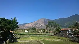
 Mount Guntur, seen from Tarogong Kaler | |
| Highest point | |
| Elevation | 2,249 m (7,379 ft)[1] |
| Listing | Ribu |
| Coordinates | 7°08′35″S 107°50′24″E / 7.143°S 107.840°E[1] |
| Geography | |
| Geology | |
| Mountain type | Stratovolcano |
| Volcanic arc/belt | Ring of Fire |
| Last eruption | October 1847[1] |
Mount Guntur (Indonesian: Gunung Guntur) is an active stratovolcano in western Java. However, since the 19th century, it has not erupted. The name Guntur means "thunder" in the Sundanese language.
The Kamojang crater, a geothermal power field and a tourist site, is located on the slopes of Mount Guntur.
See also
References
- 1 2 3 "Guntur". Global Volcanism Program. Smithsonian Institution. Retrieved 2019-11-10.
This article is issued from Wikipedia. The text is licensed under Creative Commons - Attribution - Sharealike. Additional terms may apply for the media files.

