| Mistra Bay | |
|---|---|
| Il-Bajja tal-Mistra | |
 Mistra Bay | |
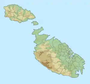
 Mistra Bay Location of Mistra Bay in Malta | |
| Location | St. Paul's Bay, Mellieħa, Malta |
| Coordinates | 35°57′29″N 14°23′30″E / 35.95806°N 14.39167°E |
| Type | Bay |
| Max. length | 385 metres (1,263 ft) |
| Max. width | 456 metres (1,496 ft) |
| Surface area | 8.51 hectares (21.0 acres) |
| Max. depth | 6.9 metres (23 ft) |
| Shore length1 | 1.2 kilometres (0.75 mi) |
| 1 Shore length is not a well-defined measure. | |
Mistra Bay (Maltese: Il-Bajja tal-Mistra) is a bay in northwestern Malta, near Mellieħa. The bay is surrounded by cliffs and is considered an inlet of St. Paul's Bay. To the north, lies Selmun Palace. The Mistra Battery is found on the east side of the bay.[1] Two restaurants are also in the north side of the bay, connected via a rugged road.[2] Several fish farms are located around 595 metres (1,952 ft) offshore.[2][3] Recent clean ups have also reduced the amount of waste found on the beach.[4] The beach present is made out of pebbles[5][6] and has been cited by Roman and Phoenician authors living in Melite.[3]
References
- ↑ "Mistra Bay, Xemxija, Malta". whichbeach.com.mt. Retrieved 2021-11-01.
- 1 2 "Mistra Bay". My Guide Malta. Retrieved 2021-11-01.
- 1 2 "Mistra Bay, Malta Tourist Information". www.touristlink.com. Retrieved 2021-11-01.
- ↑ "mistra bay Archives". 89.7 Bay. Retrieved 2021-11-01.
- ↑ TRIPinVIEW. "beach Mistra Bay". beach Mistra Bay. Retrieved 2021-11-01.
- ↑ Sammut, Sephora; Gauci, Ritienne; Inkpen, Robert; Lewis, Jessica Jade; Gibson, Andy (2019), "Selmun: A Coastal Limestone Landscape Enriched by Scenic Landforms, Conservation Status and Religious Significance", World Geomorphological Landscapes, Cham: Springer International Publishing, pp. 325–341, retrieved 2021-11-01
This article is issued from Wikipedia. The text is licensed under Creative Commons - Attribution - Sharealike. Additional terms may apply for the media files.