Minnesota Junction, Wisconsin | |
|---|---|
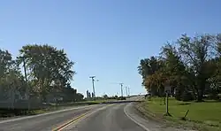 Looking south in Minnesota Junction on WIS 26 | |
 Minnesota Junction  Minnesota Junction | |
| Coordinates: 43°27′09″N 88°41′49″W / 43.45250°N 88.69694°W | |
| Country | |
| State | |
| County | Dodge |
| Town | Oak Grove |
| Elevation | 282 m (925 ft) |
| Time zone | UTC-6 (Central (CST)) |
| • Summer (DST) | UTC-5 (CDT) |
| Area code | 920 |
| GNIS feature ID | 1569566[1] |

Minnesota Junction is an unincorporated community located, in the town of Oak Grove, in Dodge County, Wisconsin, United States.[2] Minnesota Junction is located on Wisconsin Highway 26.[3] It is located at latitude 43.452 and longitude -88.697 at 925 feet above mean sea level.[2]
History
Minnesota Junction was founded when the railroad was built to that point.[4] The community was so named from the expectation the new railroad line would eventually extend from Minnesota Junction to the Minnesota Territory.[4] A post office was established in Minnesota Junction in 1861, and remained in operation until it was discontinued in 1940.[5] The junction was situation where a north–south branch of the Chicago and North Western Railway met an east–west branch of the Milwaukee Road. The north–south line was abandoned in 1984, and is now a rail trail, while the east–west line is still operated by the Wisconsin and Southern Railroad.[6][7]
References
- ↑ U.S. Geological Survey Geographic Names Information System: Minnesota Junction, Wisconsin
- 1 2 "Minnesota Junction Maps, Facts & Features". Wisconsin Hometown Locator. Retrieved November 17, 2010.
- ↑ "Location for Minnesota Junction, Wisconsin". Google Maps. Retrieved November 17, 2010.
- 1 2 Chicago and North Western Railway Company (1908). A History of the Origin of the Place Names Connected with the Chicago & North Western and Chicago, St. Paul, Minneapolis & Omaha Railways. p. 103.
- ↑ "Dodge County". Jim Forte Postal History. Retrieved March 22, 2015.
- ↑ Andrew S. Nelson (December 1993). "C&NW's Clyman Sub" (PDF). Pacific RailNews. No. 361. pp. 36–39. Retrieved March 27, 2020.
- ↑ Wisconsin Department of Transportation (January 2020). Wisconsin Railroads & Harbors 2020 (PDF) (Map).
| Preceding station | Chicago and North Western Railway | Following station | ||
|---|---|---|---|---|
| Juneau toward Janesville |
Janesville – Fond du Lac | Burnett toward Fond du Lac | ||
| Preceding station | Milwaukee Road | Following station | ||
| Rolling Prairie towards Portage |
Portage – Horicon | Horicon Terminus | ||
Municipalities and communities of Dodge County, Wisconsin, United States | ||
|---|---|---|
| Cities |  | |
| Villages | ||
| Towns | ||
| CDPs | ||
| Other communities |
| |
| Ghost towns | ||
| Footnotes | ‡This populated place also has portions in an adjacent county or counties | |
43°27′09″N 88°41′49″W / 43.45250°N 88.69694°W